This Parish Summary is an overview of the large amount of information held for the parish, and only selected examples of sites and finds in each period are given. It has been beyond the scope of the project to carry out detailed research into the historical background, documents, maps or other sources, but we hope that the Parish Summaries will encourage users to refer to the detailed records, and to consult the bibliographical sources referred to below. Feedback and any corrections are welcomed by email to heritage@norfolk.gov.uk
Great Cressingham is a small parish in Breckland, and settlement in the parish is focused on the small village. Cressingham comes from the Old English meaning 'homestead of the family or followers of a man named Cressa', or 'homestead with cress beds'.
There is some evidence for prehistoric occupation in the parish. Several flint implements (NHER 4670, 24629, 24630 and 24670) have been found including Neolithic axeheads (NHER 4671, 4672), a scraper (NHER 24631), and pot boilers (NHER 21438 and 24669). A fragment of late prehistoric pottery (NHER 31848) has also been found. A possible ring ditch (NHER 35570) is visible as a cropmark on aerial photographs in the south of the parish.
Fragments of Iron Age pottery (NHER 21438, 24629, 24630, 24632 and 31850) were recovered from the south of the parish during a fieldwalking survey. Roman pottery (NHER 4688, 21438, 31629, 24632, 24669, 24671, 31839, 31848, 31850 and 32084) has been found, as well as Roman tiles (NHER 24138 and 24669) and Roman coins (NHER 29079 and 31297). Although no Iron Age or Roman settlement sites have been identified, a field walking survey revealed the presence of an Iron Age site, and a Roman site immediately to the south of the parish boundary, in Little Cressingham. In 2002 the Norfolk Archaeological Unit carried out an evaluation in the village, which revealed a series of pits and post holes containing Iron Age pottery, Roman tile, and medieval and post medieval finds (NHER 37409).
There is no evidence of Early Saxon activity. A single fragment of Middle Saxon pottery (NHER 24670), Late Saxon pottery (NHER 32084 and 19654), and a Late Saxon iron spearhead (NHER 4688) have been found. In the Domesday Book Great Cressingham is recorded as a fairly substantial and wealthy settlement, with mills, fisheries and a church. Aerial photographs show the site of St George's Chapel (NHER 4713); the apsidal chancel and the rectangular nave are clearly visible as cropmarks, surrounded by a rectangular enclosure. The plan of the church suggests a date of about 1100, and it is mentioned in documents until the 16th century. St Michael's Church (NHER 4720) dates from the 13th century, with substantial alterations from the 15th century.

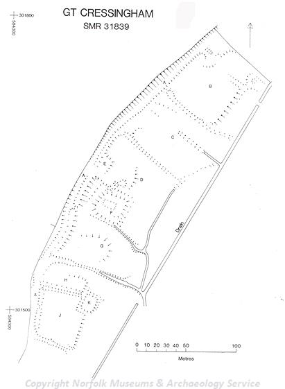
A possible medieval moated site at Great Cressingham. (© NCC.)
In 1086 Great Cressingham was almost entirely in the hands of the Bishop of Thetford, before passing to Norwich Cathedral Priory, who held land in the parish until the Dissolution. Manor Farm (NHER
4687), once known as Priory Farm, was once thought to be the site of a monastic manor. In fact, there was never a religious foundation on the site, and although the manor has been linked to the Priory of Norwich, the double moated site is thought to be that of Risley's Manor, recorded from the 15th century. In the mid 16th century the house was acquired by the Jenny family, who built an elaborate and substantial courtyard house, only a small portion of which survives. This part of the house has polygonal towers and is richly decorated with complex terracotta friezes and tracery, which hints at the splendour of the lost parts of the house. Manor Farm is surrounded by earthworks relating to the medieval village of Great Cressingham. Medieval fishponds, tofts, house platforms and hollow ways are all visible as earthworks (NHER
4688,
31848 and
31852). Two possible medieval moated sites have also survived as earthworks (NHER
31839 and
31851). Various medieval and post medieval earthwork banks and ditches have been recorded on the site of a medieval and post medieval fair (NHER
37585).
A small settlement (NHER 24670) also existed in the southeast of the parish, near Home Lane, in the medieval period. Medieval documentary references to people with the name 'de Glosbrigg' in the area around Home Lane suggest that there was a medieval manorial site in this area. From the pottery evidence activity seems to have ceased by the late medieval period.
The Vines (NHER 19654) is a late medieval timber framed hall house, that was partially rebuilt in brick in the 17th century, when upper floors were inserted into the building. Vine Cottage (NHER 41199) is a small early 19th century building made of clay lump. The cottage originally had only two rooms, and is a good example of this type of small clay lump building. During the 17th century a flint knapping site, used for making gun flints, was situated in the southeast of the parish.
Sarah Spooner (NLA), 13 January 2006
Further Reading
Brown, P. (ed.), 1984. Domesday Book: Norfolk (Chichester, Phillimore)
Davison, A., 1994. 'The Field Archaeology of Bodney and the Stanta Extension' Norfolk Archaeology vol.XLII
Mills, A.D., 1998. Dictionary of English Place-Names (Oxford, Oxford University Press)
Pevsner, N. and Wilson, B., 1999. The Buildings of England. Norfolk 2. Norwich and North-East (London, Penguin Books)
Rye, J., 1991. A Popular Guide to Norfolk Place-names (Dereham, Larks Press)