This Parish Summary is an overview of the large amount of information held for the parish, and only selected examples of sites and finds in each period are given. It has been beyond the scope of the project to carry out detailed research into the historical background, documents, maps or other sources, but we hope that the Parish Summaries will encourage users to refer to the detailed records, and to consult the bibliographical sources referred to below. Feedback and any corrections are welcomed by email to heritage@norfolk.gov.uk
Horsford is a large parish in the Broadland district of Norfolk just north of Norwich. It is located east of Felthorpe and west of Horsham St Faith and Newton St Faith. The Forestry Commission manages the north part of the parish as a pine plantation. The village name derives from the small River Hor that flows through the village and can be translated from Old English to mean ‘ford over the River Hor’ or ‘ford for horses’. Land in Horsford is recorded in the Domesday Book as being held by Edric for Robert Malet. It is very unusual that the Malet family retained the manor in Horsford until the mid 19th century. This family built Horsford Castle (NHER 8001) either as a country retreat, a base for hunting trips or for their tenant Waller of Caen.
The earliest archaeological finds recorded are several Mesolithic worked flints (NHER 13329 and 7853). Nine Neolithic flint axeheads (NHER 7771, 7998, 7999, 12306, 13053, 15183, 15185, 22459 and 35283) have also been found. A Bronze Age copper alloy axehead (NHER 8000) has been recovered. The earliest monuments are Bronze Age barrows. Two of these barrows can still be seen as earthworks (NHER 7772 and 7773) whilst other possible barrows have been identified from aerial photographs (NHER 36413, 18491 and 17476). One of these cropmarks may be the site of a medieval or post medieval windmill mound (NHER 17476) rather than a barrow. Cropmarks of four rectangular enclosures (NHER 18126, 36405, 18131 and 18907) have also been identified on aerial photographs. These enclosures may date to the Late Iron Age or Roman period.
There is very little other evidence for Roman activity. Two coins (NHER 12305 and 28271) have been recorded and one piece of Roman pottery (NHER 8001) was recovered from near the castle. There is no evidence for Saxon activity.

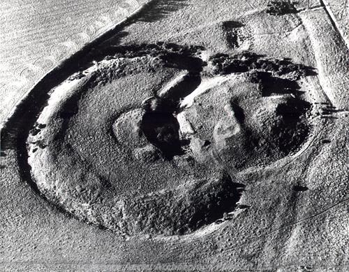
Horsford Castle from the air showing the bailey and the motte around the keep. There may have been a fortified barbican between the bailey and motte. (© NCC.)
Horsford Castle (NHER 8001) is a Norman motte and bailey castle with a defensive barbican. The stone keep that once stood on the motte can be seen on aerial photographs. Only earthworks can now be seen at the site. There is evidence to suggest that there was a deer park (NHER 40139) attached to the castle. Later this became incorporated into a post medieval landscape park. The survival of a medieval pollarded oak tree (NHER 44145) suggests the landscape was heavily managed. Areas were set aside for agriculture and field systems developed. Earthworks of one of these medieval field systems and associated tofts (NHER 29480) can be seen just west of Poplars Farm. The site of St Faith’s priory (NHER 8005) was originally located within Horsford (NHER 13934) when it was founded in 1105. It moved to nearby Horsham soon afterwards and the exact location of the earlier site is unclear. All Saints’ Church (NHER 7795) mostly dates to the 14th century although the heavy restoration of the building in 1869 has disguised many of the original features. Several interesting medieval finds have been recorded. A 14th century seal matrix (NHER 23019) depicting a hare holding a horn astride a hound was found by a metal detectorist. A 15th century ring (NHER 15897) perhaps with a dove and olive branch motif has also been recorded. A horse harness decoration with three lions picked out in red enamel has also been recovered.
St Helen’s windmill (NHER 7792), a tower mill built in 1858, replaced an earlier smock mill on the same site. The Dog (NHER 11528) is a 17th century building that was possibly originally a house. Horsford Hall (NHER 17520) was also built in the 17th century although most of this building was covered up by a Georgian brick façade in the 19th century. Many post medieval banks and ditches, probably originally field and park boundaries, have been recorded. Most of these survive as earthworks (NHER 40139, 40140, 40141, 40144 and 40145). The site of a former Keeper’s Cottage (NHER 40143) is marked on old maps and a scatter of 19th and 20th century brick and tile has been recorded at the site. A lead head from an 18th or 19th century tobacco jar (NHER 25941) has been recorded. Originally this was thought to be Iron Age or Roman – archaeologists don’t always get it right first time!
The most recent sites are a World War One trench (NHER 7781) dug on Manor Farm when troops were stationed nearby and a possible World War Two bombing decoy (NHER 18131).
Megan Dennis (NLA), 23 March 2006.
Further Reading
Brown, P. (ed.), 1984. Domesday Book, 33 Norfolk, Part I and Part II (Chichester, Philimore)
Neville, J., 2005. ‘Norfolk Mills – Horsford tower windmill’. Available:
http://www.norfolkmills.co.uk/Windmills/horsford-towermill.html. Accessed: 23 March 2006.
Neville, J., 2005. ‘ Norfolk Mills – Horsford smock windmill’. Available:
http://www.norfolkmills.co.uk/Windmills/horsford-smockmill.html. Accessed: 23 March 2006.
Norfolk Federation of Women’s Institutes, 1990. The Norfolk Village Book (Newbury, Countryside Books and Norwich, Norfolk Federation of Women’s Institutes)
Mills, A. D., 1998. Dictionary of English Place Names (Oxford, Oxford University Press)
Rye, J., 2000. A Popular Guide to Norfolk Place-names (Dereham, The Larks Press)