This Parish Summary is an overview of the large amount of information held for the parish, and only selected examples of sites and finds in each period are given. It has been beyond the scope of the project to carry out detailed research into the historical background, documents, maps or other sources, but we hope that the Parish Summaries will encourage users to refer to the detailed records, and to consult the bibliographical sources referred to below. Feedback and any corrections are welcomed by email to heritage@norfolk.gov.uk
The modern parish of Kempstone is northwest of Dereham and roughly 7.5 kilometres northeast of Swaffham. It is L-shaped, with a dispersed hamlet located in the centre east. The northern boundary partly follows the River Nar and partly the line of a Roman road. A section of the eastern boundary follows a tributary of the River Nar.
Little is known about the archaeology of Kempstone, mainly because only a small amount of archaeological work has been carried out. There have been a few site visits and a number of sites have been identified from features on aerial photographs. Only a limited amount of metal detecting and fieldwalking have taken place and a few stray finds have been reported. Sites are not evenly spread throughout, with concentrations in the northwest and around the hamlet. None are recorded in the south.
Prehistoric flint artefacts have been discovered and they include a Neolithic flint blade, a Beaker barbed and tanged arrowhead (NHER 20349), flakes and pot boilers. The pot boilers (NHER 28958) were found close to the tributary of the River Nar and suggest the location of a burnt mound. Eight possible ring ditches have been identified as cropmarks on aerial photographs. They may all be remnants of Bronze Age round barrows and are located in the north on land that slopes up from the River Nar.
The Roman road (NHER 2796) from Brampton to Denver passes from east to west through the north. This meets the north to south Toftrees to Threxton road in the west. At the junction of the two roads stray finds, fieldwalking and metal detecting have revealed a Roman small town or large village. The large number of artefacts collected includes pottery fragments, coins, metalwork and metal working debris. The metal working debris suggests that there was considerable industrial activity. To the southeast of the town or village two or three undated rectangular enclosures (NHER 13042) have been identified on aerial photographs. The discovery of pottery, coins, tiles and metalwork suggests that the enclosures could be Roman and associated with activity in the settlement.
Fragments of several Early Saxon brooches have been found at the Roman town/village site. These could suggest that activity, possibly in the form of settlement or burial, continued into the Saxon period. How long this may have continued is uncertain, although a 9th century strap end has been found close to the town/village. However, the Middle Saxon pottery (NHER 4083) discovered close to St Paul’s Church probably suggests a shift of settlement southeastwards. Late Saxon pottery has also been found near the church, which itself contains a Late Saxon window and 11th century nave walls.
Kempstone appears in the Domesday Book of 1086 as ‘Kemestuna’. This Old English name means ‘Cymi’s enclosure’. At that time land in the parish was held by William of Warenne and villagers, a slave, ploughs, meadow, woodland and pigs were recorded. Although elements of St Paul’s Church may have been standing, it was not mentioned.
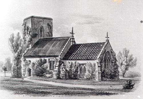
St Paul's Church, Kempstone, a Late Saxon, medieval and later parish church, drawn in the 19th century.
The ruins of St Paul’s Church (NHER
4092) are located in the hamlet. The chancel was added to the 11th century nave during the 14th century, the tower was built in the 15th century and various alterations and additions were made during the 18th and 19th centuries. By the end of the 19th century the church was disused and partly ruined. A new nave roof was added in 1904, but it had collapsed by the 1950s. The chancel arch and most of the chancel roof collapsed between 1978 and 1983.

The ruins of St Paul's Church, Kempstone, a Late Saxon, medieval and later parish church. (© NCC.)
During the medieval and post medieval period the hamlet was larger than it is today. There was settlement around the church, as evidenced by surviving earthworks, cropmarks visible on aerial photographs and the discovery of medieval and post medieval pottery (NHER
4083). It is also probable that there was settlement along the eastern edge of Kempstone Green where Kempstone Manor Farm is today. Flax retting pits have been recorded in the parish and it is possible that they were located in the north where undated linear features (NHER
11688) have been identified on aerial photographs.
Medieval and post medieval artefacts have been found and include pieces of pottery, coins, buckles, spurs and strap fittings. Kempstone Lodge (NHER 40082), a late 18th century farmhouse with an early 19th century addition, is situated to the northeast of the church.
David Robertson (NLA), 3 April 2006.
Further Reading
Ashwin, T. & Davison, A., 2005. An Historical Atlas of Norfolk (Chichester, Phillimore)
Barringer, C., 1989. Faden’s Map of Norfolk (Dereham, Larks Press)
Brown, P. (ed.), 1984. Domesday Book: Norfolk (Chichester, Phillimore)
Knott, S., 2005. 'St Paul, Kempstone'. Available:
http://www.norfolkchurches.co.uk/kempstone/kempstone.htm. Accessed: 3 April 2006.
Rye, J., 1991. A Popular Guide to Norfolk Place-names (Dereham, Larks Press)
Wade-Martins, P., 1980. 'Village Sites in the Launditch Hundred', East Anglian Archaeology 10