This Parish Summary is an overview of the large amount of information held for the parish, and only selected examples of sites and finds in each period are given. It has been beyond the scope of the project to carry out detailed research into the historical background, documents, maps or other sources, but we hope that the Parish Summaries will encourage users to refer to the detailed records, and to consult the bibliographical sources referred to below. Feedback and any corrections are welcomed by email to heritage@norfolk.gov.uk
Hempton is a tiny parish in the northwest of the county, close to the market town of Fakenham. The small village is clustered around the edge of Hempton Green. The Green is the same shape and size today as when it was depicted on Faden’s map of 1797.
The earliest archaeological find from the parish is a Neolithic flint implement (NHER 7108) that was found before 1907. A Middle Bronze Age palstave (NHER 31704) has been found on Hempton Green by metal detecting. Fragments of Roman pottery (NHER 7120) have been found, and more detailed fieldwork may uncover more evidence from the Iron Age and Roman periods.
Hempton comes from the Old English meaning ‘farmstead or village of a man named Hemma’. In the Domesday Book Hempton, which was held by William of Warenne, is recorded as a small holding, with four freemen and four smallholders and a church. Fragments of Middle and Late Saxon pottery (NHER 7109 and 7120) are the only Saxon finds so far recorded in the parish.

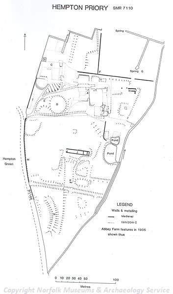
Plan of the earthworks of St Stephen's Priory, Hempton. (© NCC.)
The medieval parish church (NHER
7120) was dedicated to St Andrew, but had fallen into ruins by the early 17th century. Some fragments of flint masonry mark the site of the church off Shereford Road, which is surrounded by a series of medieval earthworks including a moated site and medieval tofts. In about 1135 an Augustinian hospital (NHER
7110) was founded in the parish. The hospital became a priory in about 1200, dedicated to St Stephen. Some lengths of the medieval precinct walls are still standing, as well as a building with fragments of medieval masonry. The earthworks of medieval fishponds and other depressions and enclosures are visible on the site. This was also the site of a bridewell, marked on Faden’s map of 1797.
In the early 16th century an inn called The Cock (NHER 14372) stood on Shereford Road, and by 1800 a brickworks stood on the site, which has now been developed for houses. The Old Post Office on Dereham Road (NHER 30614) is an early 17th century house with an original ovolo moulded window. Wensum House (NHER 43068) is an early 18th century flint and brick house, The Bell Inn (NHER 43066) is an 18th century public house and The Green (NHER 43067) is an early 19th century former public house. Holy Trinity Church (NHER 7125) is a mid 19th century Gothic Revival church, incorporating some medieval building material taken from St Andrew's Church.
Gogg’s Mill (NHER 14371) was an early 18th century watermill that was demolished in the 1950s. Two early 19th century windmills (NHER 12489 and 14370) once stood on the edge of Hempton Green.
Sarah Spooner (NLA), 2 March 2006.
Further Reading
Brown, P. (ed.), 1984. Domesday Book: Norfolk (Chichester, Phillimore)
Mills, A.D., 1998. Dictionary of English Place-Names (Oxford, Oxford University Press)
Rye, J., 1991. A Popular Guide to Norfolk Place-names (Dereham, Larks Press)