This parish summary provides an overview of the large amount of information which we hold about the parish, and only a representative sample of sites and artefacts from each period are mentioned. If you have any feedback on this article please contact us using the link on the left-hand menu or by emailing heritage@norfolk.gov.uk
Aylmerton is located in North Norfolk, about 1 kilometre southwest of Cromer. Its eastern boundary passes through Felbrigg Park. Some sections of its northern, western and southern boundaries follow roads whilst other parts cut across the landscape features.
The A148 Cromer to Holt Road passes east to west through the northern part of the parish. Modern settlement is clustered in three locations. One is alongside and to the north of the A148, centred on the A148’s junction with the Aylmerton to Runton road. Another is to the west around Aylmerton Hall with the third to the south of the A148, to the south of the church and around the road to Gresham.
The earliest recorded artefact found in Aylmerton is a Palaeolithic flint handaxe that was discovered in 1882. Other prehistoric flint artefacts include retouched flakes, a Mesolithic scraper and two Neolithic polished axeheads. A Neolithic or Bronze Age perforated stone macehead, a prehistoric stone quern, a Bronze Age copper alloy dagger, fragments of two Late Bronze Age swords and a Late Bronze Age spearhead have also been found (see NHER 31934 for the swords and spearhead).
A Roman coin dating to 90BC (NHER 14535) has been found in the very north, close to Beacon Hill. Four coins dating to the 4th century AD have been collected from the same site. Roman coins have also been found in the centre of the parish, just south of the A148 (NHER 31934 and 34279). Other Roman artefacts, a pottery sherd, a possible tile, a possible belt mount and a possible gaming piece, have been discovered at these two sites.

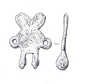
Suspension plate from a medieval horse harness pendant (©NCC)
Early Saxon brooches, tweezers, a pin and a buckle have been found at a site (NHER 31934) located in the centre of the parish. Their concentration in one location suggests that the site could include an Early Saxon inhumation cemetery. A Middle Saxon pin, a Late Saxon object and part of a medieval horse harness pendant have also been collected from the site.
Aylmerton is an Old English name meaning ‘Aethelmaer’s enclosure or farmstead’. In 1086 the Domesday Book called the parish ‘Almartune’ and described how William of Warenne and Roger Bigot held the land.
The church of St John the Baptist (NHER 12210) is a medieval building that was restored in 1865 and 1876. Its round tower may date to the 12th, 14th or 15th century. The building is located centrally within the parish in a slightly isolated position, half way between two clusters of modern settlement. To the southwest of the church is a group of ponds (NHER 6632). These may be the remains of a moat, although they could be man-made or natural ponds. Aylmerton cross (NHER 6582) stands on the southern parish boundary at the junction of four roads and is a medieval wayside cross on a pilgrimage route to Walsingham.
A group of medieval iron working pits (NHER 28916) have been identified in the north of the parish, close to Beacon Hill. The foundations of a building have been found during ploughing in the south of the parish. Medieval pottery from the site suggests that the building could be medieval in date. Metal detectorists have collected medieval and post medieval metal finds from sites in the west and centre of the parish.

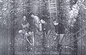
Volunteers at work in the bottom of the ice house in the grounds of Felbrigg Hall (©Eastern Daily Press)
Part of Felbrigg Park (NHER 29822) occupies a strip of land along the eastern parish boundary. It began as a medieval deer park and was developed into a landscape park from the 17th century onwards. To the north of the park, on the parish boundary with Runton, are two linear banks. They are probably post medieval wood banks. Surviving post medieval buildings in the parish include Church Farm House, Park Wall farmhouse, Park Farmhouse and a 17th or 18th century icehouse (NHER 13671). The Roman Camp public house is situated at the junction of the A148 and Church Road. It is named after a medieval or post medieval earthwork to the north that has been interpreted as a Roman camp in the past (NHER 6387 in Runton parish).
A First World War circular pillbox survives and is located close to the junction of the A148 and the Aylmerton to Runton road. Undated archaeological features in the parish include a pit located in the northeast of the parish that was excavated in 1949.
David Robertson (NLA), 13th September 2005.
Further Reading
Brown, P. (ed.), 1984. Domesday Book: Norfolk (Chichester, Phillimore)
Mills, A.D., 1998. Dictionary of English Place-Names (Oxford, Oxford University Press)
Rye, J., 1991. A Popular Guide to Norfolk Place Names (Dereham, Larks Press, Dereham)