This Parish Summary is an overview of the large amount of information held for the parish, and only selected examples of sites and finds in each period are given. It has been beyond the scope of the project to carry out detailed research into the historical background, documents, maps or other sources, but we hope that the Parish Summaries will encourage users to refer to the detailed records, and to consult the bibliographical sources referred to below. Feedback and any corrections are welcomed by email to heritage@norfolk.gov.uk
Morton on the Hill is located in central Norfolk, about 10 kilometres northwest of Norwich city centre. It is an irregularly shaped parish and its eastern boundary follows closely the sinuous course of the River Wensum. The river is fringed by marshes, with land rising up to the west from these. The hamlet of Morton on the Hill is located in the northeast alongside the A1067 Norwich to Fakenham road and close to the marshes. Morton Hall is situated in the centre amongst several large areas of woodland.
Morton on the Hill is not recorded in the Domesday Book of 1086. This may mean that there was no settlement called Morton at the time. On the other hand, a settlement called Helmingham is mentioned and it is possible that Morton was covered in its entry. This suggestion is supported by the fact that the Domesday Book mentions two churches in Helmingham and that from the 13th century onwards the settlement was referred to a ‘Helmingham alias Morton’. Over time the name Helmingham appears to have fallen out of use with the title Morton on the Hill taking pre-eminence. It has been suggested that the settlement called Helmingham (NHER 7737) was located near Morton Hall, with medieval Morton sited where the modern hamlet is.
The archaeology of Morton on the Hill is not well known. Although sites are recorded throughout the parish, they number less than forty. There have been some stray finds, a limited amount of metal detecting and fieldwalking have taken place and sites have been identified on aerial photographs. A number of site visits have been undertaken and a few historic buildings survive.
A few prehistoric flint artefacts have been discovered. These include two Palaeolithic handaxes (NHER 7724), a Mesolithic flaked axehead, a Neolithic polished axehead and a Neolithic flaked axehead or roughout. Only two prehistoric metal objects are recorded, an Early Bronze Age dagger or dirk (NHER 29344) and an Iron Age terret.
During the 1830s nine, ten or eleven Bronze Age round barrows were noted on Morton Common. Unfortunately their exact sites are not known, although they may have included a round barrow (NHER 7731) that survives close to the hamlet. Four undated ring ditches identified near the hamlet could also be the remains of round barrows, as could an undated mound (NHER 7729) and a circular bank and ditch (NHER 7730) in the northwest and an undated ring ditch near Morton Hall. If some or all of them were once barrows it is possible that they may have been amongst those seen in the 1830s. The certain barrow and many of the possible barrows are located close to the River Wensum. As such, they number amongst many that have been recorded throughout the Wensum valley.
In the west a square enclosure with a ring ditch inside (NHER 32234) is visible as cropmarks on aerial photographs. It has been suggested that the ring ditch was a Bronze Age barrow and that the enclosure is the remains of a Roman barrow. However, it is perhaps more likely that they together represent an undated infilled pit. A square ditch identified on aerial photographs close to the hamlet has been interpreted as a possible Iron Age barrow. If it is, it is one of only a handful in Norfolk.
Roman artefacts have been found in a number of places around the hamlet. They include fragments of pottery, two brooches and a knife or razor handle. Two of these sites have also yielded Early Saxon items. One has produced a large quantity and wide range of objects, including numerous fragments of brooches, wrist clasps and a heavy cast ring. The range and number demonstrate that the site was used as an inhumation cemetery (NHER 29344). A Middle or Late Saxon brooch and Late Saxon strap ends (NHER 25247) have also been recovered from the other of the two sites with Roman and Early Saxon objects. Two Late Saxon brooches and Late Saxon pottery have been found elsewhere.

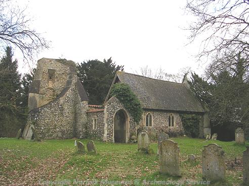
St Margaret's Church, Morton on the Hill. (© NCC)
St Margaret’s Church (NHER
7725) is located in the centre of the parish, away from the hamlet. Although it is adjacent to Morton Hall, it has been suggested that it was the originally the parish church of Helmingham and that it was located amongst the settlement of that name (NHER
7737). St Margaret’s is probably one of the two churches mentioned in the Domesday Book and much of the nave is Late Saxon, as are the ruins of the round tower. The chancel was added in the late 13th century, with a porch and chapel constructed in the 15th century. The tower survived to its full height until 1959 when it collapsed, damaging the nave and the porch. The church remained unused and unrepaired until the 1980s when the nave, chancel, porch and chapel were restored.

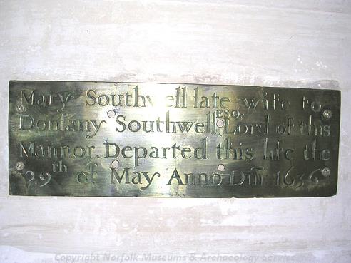
A brass inside St Margaret's Church, Morton on the Hill. (© NCC)
The placename Morton is Old English and means ‘enclosure on a moor or marshy ground’. Helmingham was called ‘Helmingeham’ in the Domesday Book. This is also an Old English name and means ‘homestead of Helm’s people’. In 1086 the Bishop of Thetford and Walter Giffard held land in the parish. Freemen, villagers, smallholders, slaves, ploughs, meadow, mills, pigs and sheep were recorded.
The second church recorded in the Domesday Book was probably St Mary’s (NHER 7741). Records from 1284 suggest that it was disused by the late 13th century and, as a result, its location is uncertain. It may have stood amongst the marshes where low earthworks and features have been identified. In the east, between the Morton and Attle bridges, was a medieval hermitage (NHER 7727). During the 1960s a medieval stone carving, possibly featuring the founder of the hermitage and his wife, was discovered at its site.
A medieval moat (NHER 14404) is visible as cropmarks and/or earthworks on aerial photographs to the east of Morton Hall. A possible second moat has been identified south of the hamlet. Only few medieval objects have been discovered and these include pottery, a harness pendant, a coin weight and a 15th century Venetian coin.

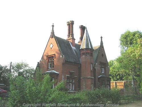
A late 19th century Gothick style lodge to Morton Hall. (© NCC)
Surviving post medieval buildings include those at Street Farm, the abattoir at the Old Butcher’s Shop, 8 and 10 The Street and the North Lodges. These lodges belong to Weston Park (NHER
33733), a small section of which occupies a part of the north of the parish. Another lodge is situated to the southeast of the hamlet, alongside a trackway leading to Morton Hall. The original Morton Hall (NHER
7726) was built in 1590, with a substantial block added in 1834 and a small extension constructed during the late 19th century. The 16th century section was demolished in 1950s following army occupation during World War Two. There is now a swimming pool on its site, although its late 16th century garden walls survive, as do both the 19th century sections. To the west of the hall are a folly (NHER
45359) and two post medieval cisterns, one or both of which may have fed the folly with water. One of the cisterns is located within a 19th century walled garden (NHER
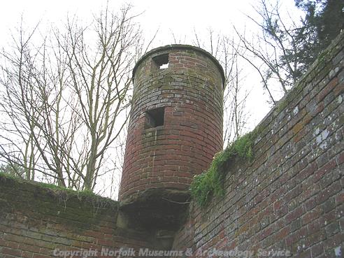
35946). A 2m tall circular brick structure with two square openings is situated at the southwest corner of the wall. It is believed to be an owl house and, if so, it is only one known in Norfolk and one of only a few recorded in the whole country.

An owl house in Morton on the Hill. (© NCC)
The route of the 19th century railway (NHER
13584) from Norwich City Station to Cromer passes through the north. It closed to trains in 1964 and now part of the Marriot's Way, a footpath and cycle track. The Attle Bridge was constructed in 1913, probably using some of the stonework from a bridge of 1668.
David Robertson (NLA), 6 July 2006.
Further Reading
Ashwin, T. & Davison, A., 2005. An Historical Atlas of Norfolk (Chichester, Phillimore)
Batcock, N., 1991. 'The Ruined and Disused Churches of Norfolk', East Anglian Archaeology 51
Barringer, C., 1989. Faden’s Map of Norfolk (Dereham, Larks Press)
Barringer, C., 1998. Bryant’s Map of Norfolk in 1826 (Dereham, Larks Press)
Brown, P. (ed.), 1984. Domesday Book: Norfolk (Chichester, Phillimore)
Dinosaur Adventure Park, 2006. 'Welcome to the Dinosaur Adventure Park'. Available:
http://www.dinosaurpark.co.uk/. Accessed: 6 July 2006
Knott, S., 2006. St Margaret, Morton-on-the-Hill. Available:
http://www.norfolkchurches.co.uk/morton/morton.htm. Accessed: 6 July 2006
Mills, A. D., 1998. Dictionary of English Place-Names (Oxford, Oxford University Press)
Rye, J., 1991. A Popular Guide to Norfolk Place-names (Dereham, Larks Press)