This Parish Summary is an overview of the large amount of information held for the parish, and only selected examples of sites and finds in each period are given. It has been beyond the scope of the project to carry out detailed research into the historical background, documents, maps or other sources, but we hope that the Parish Summaries will encourage users to refer to the detailed records, and to consult the bibliographical sources referred to below. Feedback and any corrections are welcomed by email to heritage@norfolk.gov.uk
Beeston St Andrew is a tiny parish to the north east of the city of Norwich, sandwiched between the parishes of Sprowston to the south and Crostwick to the north. Its name comes from Old English for a farmstead where bent grass grows. The St Andrew part of its name comes from the old church, which is mentioned in the Domesday Book of 1086.
The parish is one of a ring of medieval settlements around Norwich that were abandoned by the end of the 16th century as the rural population increasingly moved to the city.

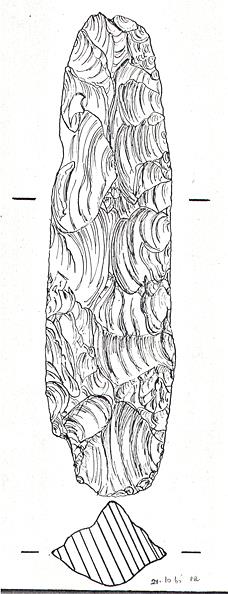
Mesolithic flint axehead from Beeston St Andrew. (©NCC)
The earliest evidence of human activity in the parish comes in the form of flint tools, the earliest one identified as a Mesolithic axe (NHER
8140). Also, a prehistoric blade has been discovered. The Neolithic period is represented by several flint axes (for example NHER
19714 and
28620). Aerial photography has revealed a ring ditch (a possibly Bronze Age burial mound, now ploughed flat) (NHER
21124), and a Bronze Age flint scraper and flake have been recovered (NHER
37316).
The Iron Age and the Roman occupation periods do not really make an impact on the archaeological record, with the exception of two cropmarks, (also from aerial photography) which may be enclosures of the time (NHER 17223 and 36451). Likewise, the Saxon period is represented by a single 10th century brooch recovered by metal detecting (NHER 34635).
Metal detecting and fieldwalking have also recovered medieval pottery and metal objects, including coins, a buckle and a harness fitting (NHER 34635). The buildings of the period have disappeared, as has St Andrew’s church (NHER 8142). The village and church were abandoned in the first half of the 16th century. The approximate site of the church is known, and there have been reports of building rubble, glazed tiles, and human bones being ploughed up. There have also been reports of building rubble turning up in other parts of the parish, which may be house remains (e.g. NHER 18125).
Post medieval objects have been recovered by metal detecting, including a lead cloth seal, lead toy, and buckles (NHER 34834 and 37219). There are three post medieval buildings on the record. Red Hall (NHER 12258), a 19th century brick mansion, stands on the site of Beeston Old Hall which dated to the early 17th century. Dairy Farm (NHER 12640) dated to the 17th century, but was demolished in the 1970s. Beeston St Andrew Hall (NHER 8174) is an 1897 rebuild, but some of its garden walls are 17th century. Lastly, there is a hydraulic pumping station (NHER 8176) that is said to have provided water for Rackheath Hall in an adjoining parish. Although now disused, this was still in good condition in 1980.
Piet Aldridge (NLA), 17 August 2005.
Further Reading
Batcock, N., 1991. ‘The Ruined and Disused Churches of Norfolk’, East Anglian Archaeology 51
Mills, A., 1987. A Dictionary of English Place Names (Oxford University Press)