This Parish Summary is an overview of the large amount of information held for the parish, and only selected examples of sites and finds in each period are given. It has been beyond the scope of the project to carry out detailed research into the historical background, documents, maps or other sources, but we hope that the Parish Summaries will encourage users to refer to the detailed records, and to consult the bibliographical sources referred to below. Feedback and any corrections are welcomed by email to heritage@norfolk.gov.uk
Bedingham is a tiny parish eleven miles south of the city of Norwich, bordered by (clockwise from the north) Woodton, Hedenham, Earsham, Denton and Topcroft. The name comes from the Saxon ‘a place of the people of Baeda’. Bedingham is mentioned in the Domesday Book, where in 1086 most of the land was owned by the King. Prior to the Norman Conquest, the land was owned by a nephew of King Harold, who was probably dispossessed.
Evidence of human activity until the medieval period is quite scarce. for reasons that are not yet clear. Prehistoric finds are limited to two Neolithic axeheads (NHER 10192 and 40549) and a segment of a ring ditch (a possible Bronze Age burial mound, now ploughed flat) seen from an aerial photograph (NHER 21077).
There is no current evidence of Iron Age habitation, and the only finds from the Roman occupation are pottery fragments (e.g. NHER 24986), a fragment of a key (NHER 24986) and a possible enclosure, again observed from an aerial photograph. There are no finds at all from the Saxon period.
The period following the Norman Conquest saw a relative explosion in activity, judging from what has been discovered in the archaeological record. The earliest building of the medieval period to survive is St Andrew’s church (NHER 10212), a rather fine building with a 12th century round tower, the remainder being largely 13th century. One reason for the relative splendour of the church is that in 1226 it was granted to Walsingham Priory, one of the richest such establishments in Europe.
The medieval period also saw something of a fashion for houses with surrounding moats. These were, it seems, rather trendy in Norfolk at this time, particularly in the central clay soil strip of the county (better for retaining water). The sites of these in Bedingham are quite common, sometimes remaining just as moats and a central island, for example at Nutyard (NHER 10204) and Willow farm (NHER 21660). At the site of Bedingham Hall (NHER 10203), there stood a medieval moated hall, that was demolished in the 19th century. As with the previous examples, what remains is the moat and the house platform.
Other earthworks are less easy to identify, and may be complex combinations of moats and ponds, as at Laurel’s Farm (NHER 10202).

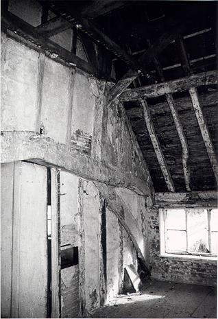
Moat Farm, a 14th or 15th century timber framed hall house in Bedingham. This photo shows the queenpost roof. (©NCC)
Some medieval buildings survive with later modification. Moat Farm (NHER
21661) and Osborne’s Farm (NHER
21817) are both medieval in origin, and both may have had moats.
On other moated sites, later buildings have replaced the original ones. An example of this is Rookery Farm (NHER 10201), a moated site with a 17th century house on the site of an earlier manor. Not only did Walsingham Priory have the parish church, it was also granted Priory Farm (NHER 12256) in 1318. The current farm building is 16th or 17th century.
Foster’s Farm (NHER 21816) is a late 16th century building, extended in about 1700, and much altered in 1960. Another post medieval feature in the parish was a windmill (NHER 18026). This was marked on old maps but was disused by the late 19th century, and was eventually demolished in 1927.
Bedingham has always been dominated by farming, and it has been noted by several writers that the landscape has changed little since 1066. The main impact of the 20th century has been the decline in its local facilities such as the blacksmith, post office, public house and shop.
The patchiness of the early archaeological record does not necessarily mean that there was no occupation at those times, and may merely reflect a lack of detailed investigation. For example, metal detecting and fieldwalking finds are relatively scarce in comparison with some other parishes.
P. Aldridge (NLA), 16 August 2005.
Further Reading
Norfolk Federation of Women’s Institutes, 1990. The Norfolk Village Book (Newbury, Countryside Books)
Pevsner, N., 1962. The Buildings of England (London, Penguin Books)