This Parish Summary is an overview of the large amount of information held for the parish, and only selected examples of sites and finds in each period are given. It has been beyond the scope of the project to carry out detailed research into the historical background, documents, maps or other sources, but we hope that the Parish Summaries will encourage users to refer to the detailed records, and to consult the bibliographical sources referred to below. Feedback and any corrections are welcomed by email to heritage@norfolk.gov.uk
Banham, from the Old English meaning ‘the homestead where beans are grown’, is a large parish on the edge of Breckland, and is now a thriving village which attracts large numbers of tourists to Banham Zoo. Banham is along an important route between Norwich and Bury St Edmunds and has been farmed and settled since at least the Iron Age.
There is important evidence for Mesolithic occupation in the parish. In the southeast corner of the parish large amounts of Mesolithic flint tools have been found on a flint working site (NHER 2259). The majority of the finds are clustered on light soils rather than heavy soils, which suggests that the Mesolithic people of Banham were living in cleared areas surrounded by dense vegetation, but only their flint tools have survived. Evidence for early occupation, such as Neolithic axeheads (NHER 10837) and other flint tools (NHER 10854 and NHER 10857), is concentrated in the south of the parish and along the parish boundary, away from the modern areas of settlement. A Bronze Age barrow (NHER 10840) at the very edge of the parish was reused in the Early Saxon period as a cemetery.
A small concentration of Iron Age finds including coins (NHER 25622), pottery (NHER 25620) and strap fittings (NHER 30933) have been found to the south of the present village. The site of a Roman villa with hypocaust, decorated wall plaster and tesserae (NHER 24627) and finds of Roman brooches (NHER 29117) and coins (NHER 31366) within the parish show that settlement in Banham continued to develop apace throughout the Roman period, and at least some of the inhabitants seem to have lived fairly luxurious lives!
The people who lived in Banham in the Early Saxon period were buried in a cemetery (NHER 10840 and 33176) to the north of the parish, close to the parish boundary. Saxon settlement continued to develop on the site of the present village and Middle Saxon coins (NHER 31313), pottery (NHER 25620) and decorative strap fittings (NHER 25734) have been found close to the village. Banham was a populous settlement in the Late Saxon period, and the Domesday Book records the presence of a church. However, St Mary’s Church (NHER 10861) does not contain any early fabric and dates mainly from the 14th century. The church contains a rare example of a medieval knight’s tomb made of wood. Banham was divided into three manors during the medieval period. Three medieval moated sites (NHER 10851, 10862, and NHER 29475) are visible in aerial photographs, although it is unclear whether any of these moated sites are the remains of manor houses.

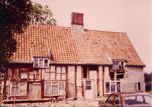
King's Head Cottage, an important 14th century timber framed cottage in Banham. (©NCC)
Many medieval timber framed buildings have survived in the village, including a rare survival of a hall house from the 14th century (NHER
19471), as well as a number of timber framed 16th and 17th century houses (NHER
22782,
19784 and
18858). Banham Hall (NHER
10843) is a large moated house dating from the 16th century. 16th century wall paintings of a dog, probably part of a larger hunting scene have been found at Chequers Farm (NHER
20141) and there is also a 16th century Guildhall, decorated with chequered brickwork (NHER
19785). Such buildings are the remains of post medieval prosperity and Banham continued to thrive into the 19th century, when brick production became an important industry in the parish (NHER
15305). One 19th century brickworks was turned into a pleasure garden to attract tourists, complete with an airship from World War One (NHER
15985).
Sarah Spooner (NLA), 5th August 2005.
Further Reading
Brown, P. (ed.), 1984. Domesday Book: Norfolk (Chichester, Phillimore)
Mills, A.D., 1998. Dictionary of English Place-Names (Oxford, Oxford University Press)
Pevsner, N. and Wilson, B., 1999. Norfolk 1. Norwich and Northeast (London, Penguin Books)
Rye, J., 1991. A Popular Guide to Norfolk Place-names (Dereham, Larks Press)