This parish summary provides an overview of the large amount of information which we hold about the parish, and only a representative sample of sites and artefacts from each period are mentioned. If you have any feedback on this article please contact us using the link on the left-hand menu or by emailing heritage@norfolk.gov.uk
Alby with Thwaite is located on the main Norwich to Cromer Road, about 4km to the north of Aylsham. Originally two parishes, Alby and Thwaite were united in 1884. Modern settlement is scattered throughout the parish, with hamlets focused around Alby Hill in the northwest, Town Green in the centre and along Thwaite Common in the south. The western parish boundary is defined by Scarrow Beck, with the southern boundary marked in part by a stream that passes through Thwaite Common. The eastern boundary passes through Gunton Park, whilst the northern boundary crosses farmland.
The earliest evidence for occupation in the parish comes in the form of two Neolithic artefacts, a flint pick (NHER 6699) and a polished stone axe (NHER 6700). Unfortunately, the exact location and nature of their discovery is uncertain. Bronze Age activity is evidenced by two axe hammers found close to Scarrow Beck (NHER 6701), a socketed axe (NHER 35445) and a barbed and tanged arrowhead (NHER 36085) found in an area sloping up from Scarrow Beck and Thwaite Common. It is possible that two flint flakes (NHER 37285) discovered close to the arrowhead may be Neolithic or Bronze Age in date, but this is not certain. The same is true of a scraper and a group of pot boilers (NHER 28803) found in the east of the parish.
A harness fitting (NHER 37285) is the only definite Iron Age artefact to have been found in the parish. This was recovered on a slope close to the confluence of Scarrow Beck and the Thwaite Common stream. A harness mount (NHER 32334) found nearby might be Iron Age in date.
Roman artefacts, including pottery, coins and brooches, have been found at locations throughout the parish although in no location is there a concentration that suggests the site of a settlement. It has been suggested that a square enclosure in the northeast of the parish could be a Roman defensive site (NHER 17208). An Early Saxon brooch (NHER 34824) and sleeve clasp (NHER 35445) have been found in the centre of the parish. Pottery, a bridle cheekpiece and coin (NHER 34824), a stirrup strap fitting and a brooch of Late Saxon date have also been recovered.
Prior to the Norman Conquest the manor of Alby was held by Asford, under King Harold. At the time of Domesday the manor had passed to Asford’s four sons, under Roger Bigot. Alby was recorded as ‘Alabei’, a Norse placename meaning ‘Ali’s settlement’. Both before and after the Conquest Thwaite was held by the Abbot of Holme. It was recorded in Domesday as ‘Tuit’, the Norse name for ‘a clearing in a wood’.

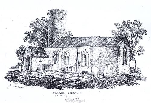
Thwaite Church, Alby with Thwaite
All Saints' Church, Thwaite (NHER 6716) stands in an isolated position on rising ground above Scarrow Beck. It is a medieval building with 19th century elements, has a round tower and a school house that was added in 1835. St Ethelbert’s Church, Alby (NHER 6820), also medieval and 19th century in date, is located to the east, within the hamlet of Town Green.
A moat, fish ponds and other earthworks close to Scarrow Beck mark the site of the medieval Somerton Hall (NHER 6712). This was the seat of Bartholemew de Somerton during the 14th century and the Hobarts in the 16th century. Medieval and post medieval metal finds, coins and pottery have been found at a number of locations throughout the parish. One of the most interesting artefacts collected is a medieval gold crucifix reliquary (NHER 13274) found in 1836.
A number of post medieval buildings survive in the parish. They include the 16th century and later Abbey Farm and Thwaite Hall (NHER 6719) which has 16th and 17th century elements. Nutmeg Cottage (NHER 17726) is mostly 18th and 19th century in date, but has 17th century beams. Walpole Barns is a collection of 18th and 19th century farm buildings (NHER 40315) and the Old Rectory dates to the 18th and 19th centuries (NHER 44134). A hydraulic ram and mill pond (NHER 24197) survive on the western side of Scarrow Beck. A World War Two spigot mortar emplacement has been recorded in St Ethelbert’s churchyard (NHER 31754). This is an unusual location for such a structure.
Undated cropmarks have been identified on aerial photographs at three locations in the parish. They include a settlement (NHER 17207) and two groups of trackways and enclosures (NHER 17209 and 33319).
David Robertson (NLA), 28 July 2005 (revised 22 March 2006).
Further Reading
Brown, P., 1984. Domesday Book: Norfolk (Chichester, Phillimore & Co.)
Norfolk Federation of Women’s Institutes, 1990. The Norfolk Village Book (Newbury, Countryside Books)
Rye, J., 1991. A Popular Guide to Norfolk Place-names (Fakenham, Larks Press)