This Parish Summary is an overview of the large amount of information held for the parish, and only selected examples of sites and finds in each period are given. It has been beyond the scope of the project to carry out detailed research into the historical background, documents, maps or other sources, but we hope that the Parish Summaries will encourage users to refer to the detailed records, and to consult the bibliographical sources referred to below. Feedback and any corrections are welcomed by email to heritage@norfolk.gov.uk
Hickling is a large parish in the North Norfolk district between the lowland heath of northeast Norfolk and the marshland further east. Here a number of small settlements are clustered around Hickling Broad (NHER 8387), a medieval peat cutting now filled with water and famous for its flora and fauna. Hickling village is located at the northwest corner of the Broad. The village is recorded in the Domesday Book as is its church and several beehives. The parish name can be translated as ‘place of Hicela’s people’ and comes from Old English.
The earliest recorded find is a Mesolithic tranchet type flint axehead (NHER 8353). Two Neolithic flint axeheads (NHER 8382 and 12881) have also been recovered. The exact location of the discovery of a Neolithic stone axe hammer (NHER 33449 or 33450) is unclear. The earliest sites recorded in the database are two possible Bronze Age barrows (NHER 29749 and 8384). These monuments have been identified on aerial photographs and cannot be seen on the ground. A copper alloy Bronze Age palstave (NHER 8387) has also been found. It was dredged out of Hickling Broad.
There is very little evidence for activity in the Roman period. Pieces of Roman pottery (NHER 12456 and 12457) have been discovered on two sites. Neither is there much archaeological evidence to suggest Saxon activity. The derivation of the village name and the recording of the settlement in the Domesday Book suggest the village may have had a Saxon origin. One piece of Middle Saxon pottery (NHER 8393) was discovered in the churchyard when a trench was dug. This led to a metal detecting survey being carried out north of the church to find evidence for Saxon settlement. Unfortunately no Saxon finds were recovered (NHER 40162).
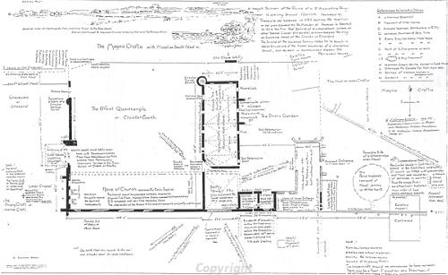
A plan of Hickling Priory drawn in 1922. The priory was founded in 1185 and dissolved in 1536.
The Augustinian priory (NHER
8384) was founded in 1185 and was dissolved in 1536. Only a small part of the church and the cloisters can be seen above ground but other features can be identified on aerial photographs. The canons are thought to have paid for the building of St Mary’s Church (NHER
8393) in the late 14th century. The building reuses materials that may have come from an earlier church on the same site. A large part of the medieval economy of the parish revolved around the extraction of peat. These peat cuttings have now been flooded or filled in. Hickling Broad (NHER
8387) is now a wildlife reserve managed by the Norfolk Wildlife Trust. The sites of Gage’s Broad (NHER
32157), Hare Broad (NHER
32158) and Wiggs Broad (NHER
35363) can be identified on aerial photographs where they show up as darker areas. They have also been seen on historical maps where their names are recorded. Another area of medieval peat cutting (NHER
27284) is not marked on maps, but the site looks very similar to cropmarks of other historical documented broads. Pieces of medieval pottery (NHER
8385,
12456,
12457,
12458 and
17983) have been found across the parish. These were probably spread around by the medieval practice of manuring. The only find from a metal detecting survey north of the church recovered a hammered silver medieval or post medieval coin and a medieval or post medieval jetton (NHER
40162). Metal detecting has also recovered medieval harness and belt fittings including a gilded example (NHER
35770).
The low-lying nature of much of the parish led to the necessity for drainage of the land. The sites of several post medieval drainage mills can be seen on old maps. These include Eastfield Mill (NHER 8390) and several other mills with unknown names (NHER 8395 and 35364). Stubb Mill (NHER 8391), another post medieval drainage mill is still standing. So is the tower windmill (NHER 8394) that was restored in 1980. The field systems (NHER 38750) identified from aerial photographs may be post medieval. Hickling Hall (NHER 43070) dates to around 1700 whilst High Hill Hall (NHER 43071) has a date plaque which reads ‘J.T. 1770’. Poplar Farmhouse (NHER 43072) was built in the 18th century.
Archaeological sites from the two World Wars are also recorded in the database. Hickling Broad (NHER 8387) was used as a seaplane base during World War One. In World War Two a searchlight emplacement was built at Eastfield Farm (NHER 34549). Access to this remote site was too difficult however and in 1939 the searchlight was moved to a more permanent site at Ouse Road (NHER 34550). It may have been the presence of the searchlight that led to the bombing of Hickling during the 1940s. A group of World War Two bomb craters (NHER 27254) has been identified on aerial photographs. It is possible that these were dropped during home bomber training missions on the marshes rather than enemy fire.
Megan Dennis (NLA), 23 February 2006.
Further Reading
BBC, 2006. ‘BBC - Norfolk Fun Stuff – 360 views: Hickling Broad’. Available at:
http://www.bbc.co.uk/norfolk/funstuff/360/hickling_broad_360.shtml. Accessed: 23 February 2006.
Brown, P. (ed.), 1984. Domesday Book, 33 Norfolk, Part I and Part II (Chichester, Philimore)
Mills, A.D., 1998. Dictionary of English Place Names (Oxford, Oxford University Press)
Neville, J., 2005. ‘Norfolk Mills – Hickling tower windmill’. Available:
http://www.norfolkmills.co.uk/Windmills/hickling-towermill.html. Accessed: 23 February 2006.
Norfolk Federation of Women’s Institutes, 1990. The Norfolk Village Book (Newbury, Countryside Books and Norwich, Norfolk Federation of Women’s Institutes)
Norfolk Wildlife Trust, 2006. ‘NWT Hickling Broad’. Available:
http://www.wildlifetrust.org.uk/norfolk/big%205/hickling.htm. Accessed: 23 February 2006.
Rye, J., 2000. A Popular Guide to Norfolk Place-names (Dereham, The Larks Press)
Unknown, unknown. ‘The Home Page of Hickling Village Norfolk’. Available:
http://www.hickling-village-norfolk.co.uk/. Accessed: 23 February 2006.