This parish summary provides an overview of the large amount of information which we hold about the parish, and only a representative sample of sites and artefacts from each period are mentioned. If you have any feedback on this article please contact us using the link on the left-hand menu or by emailing heritage@norfolk.gov.uk
The parish of Ashby with Oby lies immediately to the east of the River Bure and west of Fleggburgh parish, north west of Great Yarmouth. Ashby and Oby were originally two separate parishes. Both are mentioned in the Domesday Book and had their own individual settlements. However, today the settlements are a classic example of deserted medieval villages (NHER 11735), with little trace of the settlements or their churches remaining.
The earliest evidence of any occupation in the area comes from relatively recent aerial photography. The photographs reveal cropmarks of ring ditches; these are generally interpreted as ploughed out burial mounds of the Bronze Age period. In the 1970s, a group of eight of these ring ditches were discovered in the north of the parish (NHER 15805). There is little evidence of Iron Age settlement, save for some pottery fragments of the period.
Work on aerial photographs by the Norfolk National Mapping Programme (Broads Zone) in 2006/7 has identified an area of cropmarks on the western edge of the isle of Flegg that probably represent a Roman farmstead, enclosures and boundaries (NHER 45060 and 45102). Metal detecting has recovered a number of Roman coins.
Little is recorded for the Early Saxon period, with only a few fragments of pottery being found.
The name ending ‘by’ in Oby suggests a Viking influence, and there has been some discussion that this whole area was one of Viking incursion. However, there is no evidence of activity in the parish during this period except for a Late Saxon stirrup strap mount.
The two settlements were clearly in existence at the time of the Norman invasion. They were recorded in the Domesday Book twenty years later as being established entities.
It is in the post Conquest (medieval) era that the first evidence of structures appears. Both Ashby and Oby had a church. Of Oby church, nothing now remains, although a 17th century barn at Manor Farmhouse (NHER 8607) is said to contain fragments of it. St Mary’s Church in Ashby was demolished in the 18th century but recent aerial photographs have revealed cropmarks at the site where it stood. These show not only the outline of the church as it was before demolition, but also an earlier and possibly 11th century construction with a round tower and apsidal chancel.
Both Ashby and Oby were deserted by the 18th century and there is nothing to be seen of them today, although occasional fragments of medieval building material turn up on the site of Ashby to the north west of where the church stood. The barns at Manor Farmhouse stand on the site of Oby.
It therefore follows that the buildings that remain are either industrial or for land owning farmers. Manor Farmhouse (and the barn mentioned above) are probably the oldest, dating from the early 17th century. Ashby Hall (NHER 8555) is of early 19th century date, but its rear wing could be early 18th century.

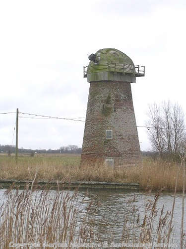
Clippesby Mill, a brick tower mill built in about 1830 (©NCC)
The remaining industrial buildings are both windmills and both were used to pump water off grazing land. Wiseman’s Mill (NHER 8604) dates from 1753, and Clippesby Mill (NHER 8605) from 1830. Both fell out of use in the 20th century but have now been restored.
Pieter Aldridge (NLA), 6 June 2006.
Further reading
Batcock, N., 1991. 'The ruined and disused churches of Norfolk', East Anglian Archaeology 51