There are a series of maps of Great Yarmouth, dating from the 16th century to the present day.
Purporting to be the earliest, the Hutch Map shows a 16th century view of the Yare estuary in 1000 AD:
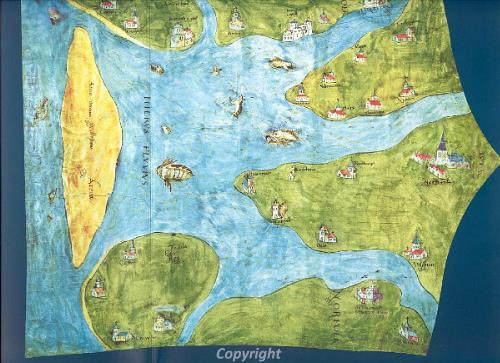
The map is painted onto the hide of a sheep (hence the shape), and has South to the top of the map, with Norwich (Norwyche) on the right hand side. The map tells us very little about Great Yarmouth, except what the Elizabethans thought the estuary looked like!
There were several Elizabethan maps of Great Yarmouth, including the map of Great Yarmouth in the British Library (Shelf Mark Cott.Aug.I.i.74), which shows the town in 1585. The purpose of this map is not known, but it may have something to do with defence: the walls and towers are very clearly shown, while the inside of the town is fairly vague. However, certain larger features are visible on the map, such as the recently dissolved friaries, the church and the Haven entrances.
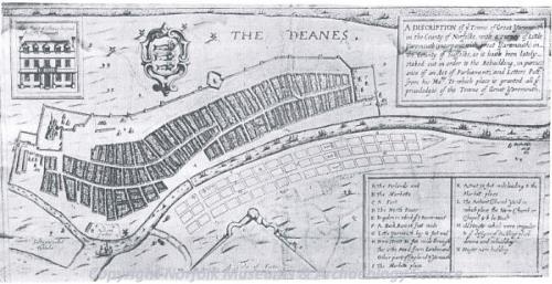
This map was drawn for Sir Robert Paston, in 1668. Sir Robert Paston had just succeeded in incorporating Little Yarmouth with Great Yarmouth (thereby giving Little Yarmouth residents the same rights to the Haven), and wished to sell land in Little Yarmouth as a viable alternative to Great Yarmouth. Little Yarmouth had a wide, spacious quay, a grid pattern of streets (claimed as the surest path to commercial growth) (Gauci, 1996, 118). Paston's map, therefore, was designed to show Little Yarmouth in its best light, while portraying Great Yarmouth as a dark maze of little alleys, limited in size by the town walls.
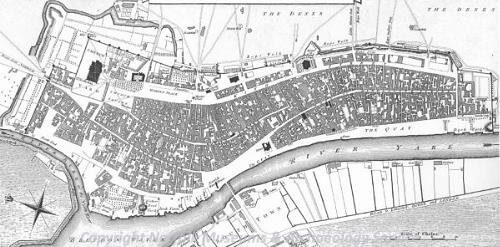
Henry Swinden conducted the first really accurate survey of the town, in 1753. He published his map in his History and Antiquities of the Ancient Borough of Great Yarmouth (Swinden, 1772, frontispiece). The map was updated and republished several times, well into the 19th century (e.g. Preston, 1819). The most widespread version of Swinden's map was published by William Faden, as part of his 1797 Map of Norfolk (Faden, 1989), illustrated above. As both Swinden and Faden intended to show an objective view of the town, the map is reasonably accurate, with no particular aspect emphasised over any other. In fact, this map remained the most accurate map of Great Yarmouth until the publication of the first edition of the 25" Ordnance Survey, in 1880.
Since 1880, the Ordnance Survey has produced regular plans of the town. You can compare the 1st edition Ordnance Survey with aerial photography from 1946 and 1988, along with other maps of Great Yarmouth and Norfolk on the e-map explorer website, while modern maps are available from the Ordnance Survey.
Click here for the Great Yarmouth bibliography.