This Parish Summary is an overview of the large amount of information held for the parish, and only selected examples of sites and finds in each period are given. It has been beyond the scope of the project to carry out detailed research into the historical background, documents, maps or other sources, but we hope that the Parish Summaries will encourage users to refer to the detailed records, and to consult the bibliographical sources referred to below. Feedback and any corrections are welcomed by email to heritage@norfolk.gov.uk
The parish of Thetford is situated in the south of Norfolk on the border with Suffolk. It lies west of Brettenham and Kilverstone southwest of Croxton and southeast of Lynford. The name Thetford may derive from the Old English meaning ‘The people’s ford, important ford’. The parish has a long history and was well established by the time of the Norman Conquest. Its population, land ownership and productive resources were detailed in the Domesday Book of 1086. This document revealed that the lands of Thetford were owned by the king, but that Roger Bigot, the Abbot of St Edmunds and the Abbot of Ely all had holdings here. Four churches are mentioned: St Martin’s, St Margaret’s, St Peter’s and St Edmund’s, and a monastery is also recorded. In terms of agricultural resources, Thetford had several mills in operation at this time and also possessed a large quantity of sheep.

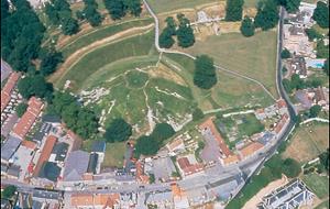
Aerial photograph of Thetford Castle. (© NCC)
For ease of reading this large parish summary has been split into chronological time periods. As such readers should choose the appropriate links below:
Prehistoric to Roman Thetford
Saxon to medieval Thetford
Post medieval to modern Thetford
Thomas Sunley (NLA) 9 August 2007.
Further Reading
Brown, P. (ed.), 1984. The Domesday Book (Chichester, Phillimore & Co.)
Dallas, C., 1993. Excavations in Thetford by B. K. Davison between 1964 and 1970. EAA Report no.62 (Gressenhall: East Anglian Archaeology)
Mortlock, D. P. and Roberts, C. V., 1985. The Popular Guide to Norfolk Churches: No.3 West and South-West Norfolk (Cambridge: Acorn Editions)
Neville, J. 2004. ‘Thetford Watermill’. Available:
http://www.norfolkmills.co.uk/Watermills/thetford.html. Accessed: 12th July 2007
Pevsner, N. and Wilson, B. 1999. The Buildings of England, Norfolk 2: North-West and South (London, Penguin)
Rogerson, A. and Dallas, C. 1984. Excavations in Thetford: 1948-59 and 1973-80. EAA Report no.22 (Gressenhall: East Anglian Archaeology)
Rye, J., 1991. A Popular Guide to Norfolk Place Names (Dereham: The Larks Press)
Wade-Martins, P. (ed.), 1997. Norfolk from the air: volume I (Hunstanton: Witley Press)
Wallis, H., 2004. Excavations at Mill Lane, Thetford 1995. EAA Report no.108 (Gressenhall: East Anglian Archaeology)
Wikipedia, 5 July 2007. ‘Thetford’. Available:
http://en.wikipedia.org/wiki/Thetford. Accessed: 12th July 2007