Viking raiders took winter quarters in Thetford in 869, the same year that King Edmund of the East Angles was killed after a battle with the Danes near the town. It is not known exactly when Danish Vikings actually settled in Thetford but it is likely to have been in the late 880s. The town developed rapidly in the 10th century on both banks of the River Little Ouse to become a major Anglo-Scandinavian settlement. It was badly damaged by a raid of King Swein Forkbeard of Denmark in 1004.
The town recovered from this attack but, by about 1100, was in serious decline. Most of the area of the south bank was abandoned and remained open land well into the 20th century. Major development only took place after World War Two and thus, while new building was accompanied by archaeological excavation which has increased substantially our knowledge of Anglo-Scandinavian Thetford, modern streets south of the river do not in general follow the line of Viking-Age streets.
Nevertheless placenames, church dedications, archaeological finds and, north of the river in particular, the surviving street pattern all give clues to where the Danes lived and worked. A thousand years ago, Thetford was a truely Anglo-Scandinavian town.
This trail will help you to find Viking Thetford for yourself. It is a circular walk starting and ending at the Town Bridge and lasting between one and a half and two hours.
1. Town Bridge - NHER 30546
The crossing here remained the main focus of traffic throughout the Middle Ages and is likely to have formed the principal river crossing for the Anglo-Scandinavian borough. It is likely that wharves lined both banks of the river at this point.
2. Thetford Grammar School - NHER 5750
The school occupies the site of St Mary the Great (NHER 5750), probably the largest church in the Anglo-Scandinavian town. The seat of the bishopric was moved here by Bishop Herfast in 1071. Thetford remained the centre of the diocese until 1094 when the see was again transferred, this time to Norwich where it remains.

Thetford Grammar School, incorporating parts of Thetford Priory.
On the left, modern housing obscures the fall of the hillslope to the river and a further river crossing at Ditchingford or Inselford. Note also the remains of the medieval priory of the Canons of the Holy Sepulchre (NHER 5749). The priory church is open to the public. Details of access and facilities can be found here.

Remains of the Priory Church of the Canons of the Holy Sepulchre, Thetford.
3. Red Castle - NHER 5746
The mound is known as Red Castle (NHER 5746). It is a 12th century Norman motte or mound but it was built at the end of a defensive Danish earthwork which runs south and eastward from this point. The earthwork, consisting of a ditch nearly 14m wide with an inner bank surmounted by a wooden palisade, defended a large area of Thetford on the south bank with the river to the north.

Excavations of articulated skeletons at Red Castle, Thetford. (© NCC)
4. Anglo-Scandinavian settlement - NHER
24822You are walking through an area (NHER 24822) which was excavated archaeologically in both the 1960s and the late 1980s. Anglo-Scandinavian gravel-surfaced roads were discovered by the archaeologists together with the remains of houses and workshops. The discoveries included pottery kilns for the manufacture of 'Thetford-type' ware, the earthenware pottery which is found across eastern England.
5. Anglo-Scandinavian defensive bank - NHER 5886
You are walking through the remains of a Danish or Anglo-Scandinavian defensive bank (NHER 5886). Originally constructed about AD900, it would have been higher with a ditch to the south (in front of you) and a timber fence on top.
Go up the steps on the left towards the school gate. You can see the bank running ahead through the trees. This defensive feature is the only upstanding Viking earthwork in Norfolk.
As you walk down London Road to the traffic lights, you will feel a slight undulation under your feet. This is the line of the bank and ditch of the Danish earthwork (you can see it again on your left in the playing field).
6. Town sign depicting King Swein or Svein Forkbeard
7. St Mary's Church - NHER 5909

Interior of St Mary the Less Church, Thetford. (© NCC)
St Mary the Less is probably a church of Anglo-Scandinavian origin although the surviving fabric is generally late medieval and post medieval in date. It stands in an area which remained occupied after much of the town on this side of the river became open land.
8. Mill buildings - NHER 33902
At the end, on the left, are mill buildings (NHER 33902) which stand astride the river and which occupy a site known for its mills since the Domesday Book survey of 1086. The Bishops Mill stood here, one of seven in the Thetford area mentioned in the great survey.
9. Anglo-Scandinavian buildings - NHER 1022
On the right, in Watermill Green, new houses occupy the site of Anglo-Scandinavian buildings excavated in the 1990s (NHER 1022). These wooden houses included cellared structures with retaining walls of timber and steps cut into the earth also being faced with wood. The new estate backs on to Bury Road where a church dedicated to St Edmund (NHER 5868), the East Anglian king martyred by the Danes, once stood.

Stone coffin found on the site of St Edmund's Church, Thetford.
The defensive earthwork met the river at Nun's Bridges but all traces of it here are now lost above ground. Nun's Bridges stand on the site of the third Anglo-Scandinavian river crossing.
10. Thetford Castle - NHER 5747
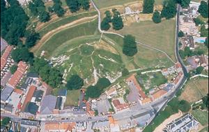
Thetford Castle from the air. (© NCC)
The great mound of the motte and bailey castle (NHER
5747) is a Norman structure, building of which started soon after the conquest of 1066. It lies astride a probable further Anglo-Scandinavian defensive ditch forming an extension of a defended enclosure on the north bank of the river. The castle is open to the public. Details of access and facilities can be found here.

Excavations at Thetford Castle, 1962. (© NCC)
11. ReymundsgateRaymond Street was formerly Reymundsgate from the Old Norse word gata meaning street. At the Library, a lane drops down to the river where there is another mill.
12. Excavations at the library - NHER 32339
Archaeological excavation behind the Library (NHER 32339) discovered a defensive ditch here, another part of the Anglo-Scandinavian defences.
Cross the road from the Library and walk up Well Street to St Cuthbert's Church (NHER 5914) and the Market Place (13).

St Cuthbert's Church, Thetford.
13. Market PlaceSt Cuthbert was a Northumbrian saint and church dedications to him are rare in southern England. However, there was also a church of St Cuthbert in Norwich and, like the Thetford example, it was situated next to the Anglo-Scandinavian market place.
14. St Peter's Church - NHER 5907
The church is mentioned by name in the Domesday Book of 1086 and was established before the Conquest. The fabric is now largely late medieval in date but the original building stood close to the heart of the northern part of the town.
Walk down Bridge Street to return to Town Bridge.
B. Ayers (NLA), 2001.
Further Reading
Crosby, A., 1986. A History of Thetford (Phillimore, Chichester).
Margeson, S., 1996. 'Viking Settlement in Norfolk: a Study of New Evidence' in S. Margeson, B. Ayers and S. Heywood (eds), 1996. A Festival of Norfolk Archaeology (Norfolk and Norwich Archaeological Society, Norwich).
Margeson, S., 1997. The Vikings in Norfolk (Norfolk Museums Service, Norwich).