This Parish Summary is an overview of the large amount of information held for the parish, and only selected examples of sites and finds in each period are given. It has been beyond the scope of the project to carry out detailed research into the historical background, documents, maps or other sources, but we hope that the Parish Summaries will encourage users to refer to the detailed records, and to consult the bibliographical sources referred to below. Feedback and any corrections are welcomed by email to heritage@norfolk.gov.uk
Neatishead parish is in the North Norfolk district. It lies southwest of Barton Turf and northwest of Hoveton. The village name comes from Old English and probably means ‘household of a retainer’ or ‘Sneat’s household’.
The oldest objects recorded in the database are a group of Neolithic worked flints (NHER 8291). A piece of Neolithic pot (NHER 28251) has also been found. A Late Bronze Age socketed axehead (NHER 34510) was also recovered.
There are very few Roman finds. Pieces of Roman quern and pot (NHER 8292) were discovered in one area. The lack of finds does not necessarily indicate an absence of activity during at this period. The general low level of recorded finds from the area is the result of a low level of archaeological work here rather than an absence of archaeological evidence.
The only Saxon finds are some pieces of Late Saxon pot (NHER 8293). As in the Roman period, however, this does not mean that there was no activity here. The Domesday Book records land in the parish that belonged to the abbey of St Benet at Holme. The book was a census of the population and productive resources of the country. The inclusion of the parish demonstrates that it was settled before the Norman Conquest. It also records that land in the parish supported four head of cattle and five pigs.
By the medieval period there is more evidence for settlement. The earliest parts of St Peter’s Church (NHER 8432) are the two eastern bays that formed the chancel of a medieval church. The nave, two aisles and tower of this church are said to have been destroyed in 1790 when the western bay was built. In the medieval period large areas of peat were cut to provide fuel. These peat cuttings subsequently flooded and became broads (NHER 13512 and 44119). Although no medieval buildings survive (apart from the church) parts of reused medieval stones from earlier structures can be seen in two of the houses in the village (NHER 13133 and 14921). A medieval coin (NHER 22422) and a harness pendant (NHER 37233) have also been recorded.
In the post medieval period parts of the parish were integrated into large grand landscape parks. Hoveton Hall (NHER 8297) was built in white brick in the late 18th or early 19th century. It has been ascribed to Humphrey Repton and Sons. There is a red brick service wing and stables. The extensive landscape park (NHER 30514) is recorded from the 18th century with a serpentine lake and blocks of woodland. Repton advised on the layout of the site. There is also an 18th century kitchen garden, a 20th century water garden and ornamental greenhouses (one of which has been demolished).
The parish also includes parts of Beeston Park (NHER 30432). The present park was designed in 1770 by Mr Richmond but an earlier park existed in 1756. Later advice was possibly given by Repton and a stream was dammed to create a lake. Aerial photographs show the layout of possible earlier formal gardens. The stables for the hall (NHER 13133) have been mostly demolished but one wall has been rebuilt into Gothic Cottage.
Other more mundane post medieval buildings also survive. Hoveton tower mill (NHER 8428) is a tarred brick four storey tower with an aluminium roof. It still contained much of the machinery in 1986 when it was being used as a diesel powered mill. The mill was built in 1812 on the site of an earlier post mill that is marked on Faden’s map of Norfolk published in 1797. The sites of other buildings – a drainage pump (NHER 15937) and a brick kiln (NHER 16676) are also recorded in documentary sources.

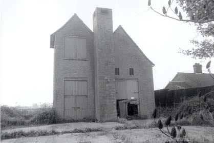
Cold War battle headquarters at Neatishead. The headquarters are disguised as a house. (© NCC)
The parish is well known for a very modern archaeological site - RAF Neatishead (NHER
31218). The site opened in 1941 and has been used as a radar station over the last sixty years. It is the longest occupied radar station in Britain and probably the world. The site was of paramount importance during the Cold War and includes the last Cold War radar assembly in Britain. This was designed to burn through Soviet radar screens and was so powerful it would microwave seagulls that landed on it. The site is now partly used as museum.
The site of a Cold War battle headquarters (NHER 35784) is located a short distance from RAF Neatishead. The headquarters were disguised as a house. It was built around 1960 and would have been used if the RAF Neatishead radar station (NHER 31218) was put out of action. The building is now used as a farm store.
Megan Dennis (NLA), 17 July 2006.
Further Reading
Neville, J., 2004. ‘Neatishead tower windmill’. Available:
http://www.norfolkmills.co.uk/Windmills/neatishead-towermill.html. Accessed: 17 July 2006.
Knott, S., 2004. ‘St Peter, Neatishead’. Available:
http://www.norfolkchurches.co.uk/neatishead/neatishead.htm. Accessed: 17 July 2006.
Mills, A. D., 1998. Dictionary of English Place Names (Oxford, Oxford University Press)
Brown, P. (ed.), 1984. Domesday Book, 33 Norfolk, Part I and Part II (Chichester, Philimore)
Rye, J., 2000. A Popular Guide to Norfolk Place-names (Dereham, The Larks Press)