This Parish Summary is an overview of the large amount of information held for the parish, and only selected examples of sites and finds in each period are given. It has been beyond the scope of the project to carry out detailed research into the historical background, documents, maps or other sources, but we hope that the Parish Summaries will encourage users to refer to the detailed records, and to consult the bibliographical sources referred to below. Feedback and any corrections are welcomed by email to heritage@norfolk.gov.uk
Marshland St James is a large West Norfolk Fenland parish about seven miles southwest of King's Lynn. The meaning of the first part of its name is self explanatory, the second part coming from a medieval chapel that stood in the parish.
For all its size, evidence of early human activity in the parish is sparse, for the simple reason that it was too wet to use as anything other than grazing land. There are no Stone Age finds, and later settlement has tended to concentrate along The Smeeth Road, a slightly raised infilled ancient river course running along the northwest edge of the parish. The earliest dateable finds are a Bronze Age copper alloy palstave (NHER 4472) and two spearheads (NHER 4471), all found in the 19th century. There are no Iron Age finds at present, but large quantities of Roman pottery and brick fragments (NHER 19034) discovered south of Trafford House on the northwest edge of the parish indicate a settlement there. Roman pottery fragments have also been found further south on the parish edge (NHER 19033). There is currently no evidence of Saxon activity.
The oldest surviving medieval structure is Old Podyke Bank (NHER 13279). Forming part of the southern boundary of the parish, this is an earthwork bank, originally dating to about 1223, but much repaired and altered over the years. Today, much of it has been levelled and cultivated, though some parts can still be seen. The medieval chapel of St James (NHER 17028) stood somewhere along The Smeeth Road, but was washed away by floods. It seems that the marshy fen in the south of the parish was exploited more intensively in medieval times, both for peat extraction and grazing. Aerial photography has shown the cropmarks of various possible livestock drove roads and ditches running broadly north to south in the marshland (NHER 19286 to 19294).
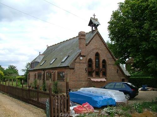
St Jame's Church, Marshland St James. The church was built in 1896 to 1897 and was converted into a house in 2002. Photograph from www.norfolkchurches.co.uk (© S. Knott.)
Continued drainage in post medieval times made use of drainage windpumps. Two of these were sited on the northeast boundary of the parish, but have now gone (NHER
16345 and
19386). The only post medieval building of note is St James’ Church (NHER
2391). This is a modest red and yellow brick mission church of 1896 to 7, which replaced a corrugated iron church of 1883. The building is in the form of a plain rectangle with an apsed chancel. Inside, the furnishings are mainly of the 1890s, except a 17th century continental painted statue of St James. There are various paintings in the apse by Lilian Dagless of Walsingham.
The most historically recent entries on the record relate to World War Two. In the south of the parish stands a type 22 hexagonal concrete pillbox (NHER 18538), part of the anti invasion defences of 1940. To the northeast of Bodges Farm, a Spitfire fighter aircraft that crashed during the war was excavated in 1986 (NHER 22699)
Piet Aldridge (NLA), 5 June 2006.
Further Reading
Silvester, R. J., 1988. The Fenland Project Number 3: Marshland and the Nar Valley (Norfolk, East Anglian Archaeology Report 45)