This Parish Summary is an overview of the large amount of information held for the parish, and only selected examples of sites and finds in each period are given. It has been beyond the scope of the project to carry out detailed research into the historical background, documents, maps or other sources, but we hope that the Parish Summaries will encourage users to refer to the detailed records, and to consult the bibliographical sources referred to below. Feedback and any corrections are welcomed by email to heritage@norfolk.gov.uk
Helhoughton is a small parish in northwest Norfolk. The small village of Helhoughton is in the east, close to the large landscape park surrounding Raynham Hall. Helhoughton Common is shown on Faden’s map of 1797, and although it is now less extensive the common still dominates the landscape to the north of the parish. The small hamlet of Painston depicted on Faden’s map has now virtually disappeared; Painswhin Farm (NHER 43060), which dates to the 18th century, now stands on the site.
There is some evidence for prehistoric occupation in the parish. A prehistoric flint flake (NHER 15517) and scrapers (NHER 16941) have been found, as well as a Neolithic quern (NHER 2356), a Neolithic knife (NHER 16941) and other Neolithic flints (NHER 29872 and 29873). A Neolithic axehead (NHER 14444) was found during the construction of the railway in 1879. A ring ditch (NHER 35561), probably dating to the Bronze Age, is visible as a cropmark and a soilmark on aerial photographs.
The site of a possible Roman building (NHER 2358) has been discovered near Valley Farm. Roman pottery and roof tiles were found on the site. Parts of a Roman quern (NHER 2357), fragments of Roman pottery (NHER 2357 and 15517) and a Roman hair pin (NHER 40294) have been found, although no specific Roman settlement site has yet been identified.
Helhoughton comes from a mixture of Old English and Old Scandinavian meaning ‘farmstead of a man named Helgi’. Helhoughton is recorded in the Domesday Book as being held by several different landholders, including the King and William of Warenne. Helhoughton is included as an outlier of Raynham, with a salt house, a fishery, a mill, meadow and woodland. Fragments of Middle Saxon pottery (NHER 15517) are the only Saxon finds to have been recovered from the parish, although more extensive fieldwork could shed more light on the landscape and settlement of the Saxon period.

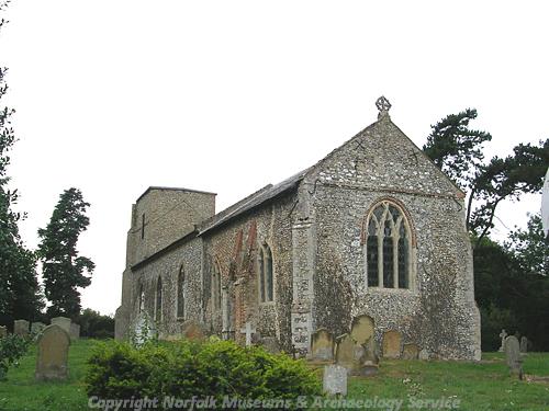
All Saints' Church in Helhoughton. (© NCC.)
All Saints’ Church (NHER
2377) dates mainly from the 14th and 15th centuries with later alterations and restoration. The church has a medieval octagonal font and a 15th century memorial brass. The earthworks of a possible medieval moat (NHER
31155) are close to the parish church. An earthwork enclosure (NHER
35050) on the edge of Helhoughton Common has also been interpreted as a possible medieval moat. Medieval pottery (NHER
2359 and
15517) and other medieval and post medieval metal finds (NHER
15517 and
32900) have been found.
Wood Farm (NHER 34734) is a 17th century house with later alterations. The house may originally have been timber framed. Valley Farm (NHER 43061) and 61 Buck Yard (NHER 43062) also date to the 17th century. The Buck (NHER 43059), a former public house, is a late 18th century flint and brick building. The site of Raynham Estate brickworks (NHER 28648), on the edge of the parish, is shown on 19th century Ordnance Survey maps.
West Raynham airfield (NHER 3685) extends into the parish. The airfield was opened in 1939 and was operational until 1994. The Cold War buildings on the airfield are of national importance, and include a Bloodhound missile site and an unusual control tower. The site of a World War Two aerial mast (NHER 36146) is visible as a cropmark on aerial photographs. The mast was probably connected with West Rudham airfield (NHER 13630).
Sarah Spooner (NLA), 1 March 2006.
Further Reading
Brown, P. (ed.), 1984. Domesday Book: Norfolk (Chichester, Phillimore)
Mills, A.D., 1998. Dictionary of English Place-Names (Oxford, Oxford University Press)
Rye, J., 1991. A Popular Guide to Norfolk Place-names (Dereham, Larks Press)