This Parish Summary is an overview of the large amount of information held for the parish, and only selected examples of sites and finds in each period are given. It has been beyond the scope of the project to carry out detailed research into the historical background, documents, maps or other sources, but we hope that the Parish Summaries will encourage users to refer to the detailed records, and to consult the bibliographical sources referred to below. Feedback and any corrections are welcomed by email to heritage@norfolk.gov.uk
East Carleton, from Old English and Old Scandinavian meaning a ‘farmstead or estate of the freemen or peasants’, is a small parish to the southwest of Norwich.
Some prehistoric flint implements (NHER 9475) have been found in the parish, including prehistoric scrapers (NHER 30575) and a Neolithic axehead (NHER 22759). Two Bronze Age axeheads (NHER 11127, 11128), made of copper alloy, and a Bronze Age palstave (NHER 11126) have been found in the parish, and several Bronze Age urned cremations (NHER 22811) were excavated by the Norfolk Archaeological Unit in 1986. Roman pottery was found inside a Bronze Age round barrow (NHER 5009) in the early 19th century. Prehistoric and Roman pottery (NHER 22652) were found in a series of pits excavated by the Norfolk Archaeological Unit in 1986. Fragments of Iron Age pottery (NHER 28308), Roman pottery (NHER 9476) and a Roman coin (NHER 33083) have been found in the parish, but no settlement sites can be identified with any certainty.
Early Saxon and Middle Saxon pottery (NHER 22652), an Early Saxon strap fitting (NHER 33083) and a Middle Saxon strap fitting (NHER 34417) have been found by metal detecting in the parish. The deserted settlement of Walsingham (NHER 14406) is mentioned in documents from the 1040s, and in Domesday Book, which recorded a church in the settlement. Walsingham comes from the Old English meaning ‘homestead of the family, of followers, of a man named Wæl’. The exact location of the settlement within the parish is unknown, as are the details of its desertion.
East Carleton itself is recorded in the Domesday Book as a fairly substantial settlement, with several different landholders, and is recorded as having two churches. During the medieval period two churches were in use in the village, St Mary’s (NHER 9517) and St Peter’s (NHER 9502), both in the same churchyard, although neither church has any surviving architectural evidence of a Late Saxon building. The two churches were united in 1441, and St Peters (NHER 9502) was in ruins by the mid 16th century. St Mary’s (NHER 9517) dates mainly from the 13th and 14th centuries, and the tower was rebuilt in the late 19th century.
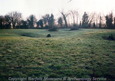
Earthworks of possible medieval fishponds at Curzon Hall, East Carleton. (© NCC)
North Farmhouse (NHER
34062) and Walnut Tree Cottage (NHER
34063) are both 16th and 17th century timber framed houses, which originally had open halls. Majority Cottage (NHER
40069) is a 16th century timber framed house, which was remodelled in the mid 19th century. Curzon Hall (NHER
9521) is a late 16th century timber framed house, which may incorporate elements of an earlier building. To the northwest of the Hall are the earthworks of possible medieval fishponds (NHER
9521). The Shooting Lodge (NHER
34060), or Manor Farm, is a 17th century brick farmhouse with decorative gables, and Carlton Lodge is a 19th century Gothick cottage (NHER
9526).
Sarah Spooner (NLA), 7 November 2005.
Further Reading
Brown, P. (ed.), 1984. Domesday Book: Norfolk (Chichester, Phillimore)
Mills, A.D., 1998. Dictionary of English Place-Names (Oxford, Oxford University Press)
Rye, J., 1991. A Popular Guide to Norfolk Place-names (Dereham, Larks Press)