This Parish Summary is an overview of the large amount of information held for the parish, and only selected examples of sites and finds in each period are given. It has been beyond the scope of the project to carry out detailed research into the historical background, documents, maps or other sources, but we hope that the Parish Summaries will encourage users to refer to the detailed records, and to consult the bibliographical sources referred to below. Feedback and any corrections are welcomed by email to heritage@norfolk.gov.uk
Thurlton is a small parish and situated 9km from the coast in the southeast of Norfolk. The parish contains the villages of Thurlton and Lower Thurlton, as well as the Thurlton Marshes and has an area of 520 hectares, containing approximately 800 people.
The earliest recorded monument is the remains of a possible Bronze Age causeway (NHER 10705) across the marsh, recorded during the construction of an electricity pylon. The earliest objects are two Neolithic axeheads (NHER 10697 and 10698), as well as a Neolithic flint sickle (NHER 25470). From the Iron Age a terret (NHER 34820) has been recovered, as well as an interesting Nauheim derivative brooch (NHER 25572).

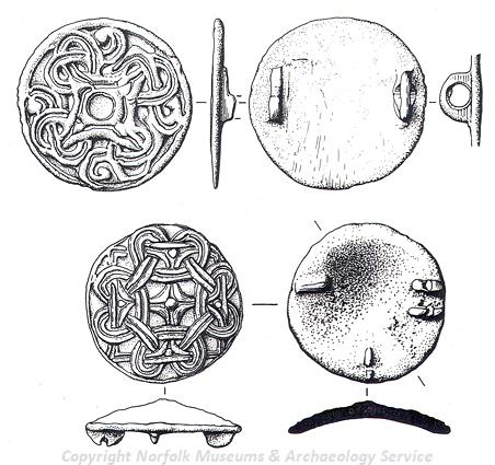
Two Late Saxon disc brooches from Thurlton. (© NCC)
Although no Roman or Saxon period monuments have been recorded, two Roman coins have been discovered (NHER
36225), as well as two Late Saxon disc brooches (NHER
19353) and a Late Saxon strap fitting (NHER
36226).
The earliest surviving structure is therefore All Saints’ Church (NHER 5287), which is thought to date to the early medieval period and still retains a fine Norman south doorway in the nave. The chancel dates to the 13th or 14th century, though the majority of the building is the product of a major rebuilding in the 1440s.
Also of possible medieval date is a medieval well (NHER 15096), discovered under the floor of a post medieval house. A number of earthworks including a house platform, ditches and an enclosure (NHER 33296), just north of Lower Thurlton, may also be medieval or post medieval in date. A small number of medieval objects have also been recovered, comprising a spinde whorl and weight (NHER 36226), a Late Saxon or early medieval bell (NHER 36225), two coins and a seal matrix (NHER 39383) and an inscribed lead plaque (NHER 36224). There are also a small number of post medieval buildings of architectural interest, including Hall Farmhouse (NHER 17155), a late 18th or early 19th century building of brick containing a 19th century cock-fighting pit with viewing balcony, as well as Whitehouse farmhouse, a 17th or 18th century two storey house of brick.
From more recent history three storeys of the Great Goliath Mill (NHER 5286) survive, a brick tower mill known to have operated until 1908. The parish is also bordered to the north by the New Cut (NHER 13535), a canal built in 1833 to allow ships to travel from Lowestoft Harbour directly to Norwich. World War Two also left a mark on the parish, with one spigot mortar emplacement surviving (NHER 36800).
Ruth Fillery-Travis (NLA), 8 June 2007
Further Reading
Knott, S., February 2005. ‘All Saints, Thurlton. Available:
http://www.norfolkchurches.co.uk/thurlton/thurlton.htm. Accessed: 8 June 2007
Morris, J. (General Editor), 1984. Domesday Book, 33 Norfolk, Part I and Part II (Chichester, Phillimore & Co)
Pevsner, N., 1997. The buildings of England: Norfolk 2: North-West and South (London, Penguin Books)
Rye, J., 1991. A Popular Guide to Norfolk Place Names (Dereham, The Larks Press)
Unknown, Unknown. ‘Thurlton Village’. Available:
http://www.eastspace.net/thurlton/DisplayArticle.asp?ID=2238. Accessed: 8 June 2007