This Parish Summary is an overview of the large amount of information held for the parish, and only selected examples of sites and finds in each period are given. It has been beyond the scope of the project to carry out detailed research into the historical background, documents, maps or other sources, but we hope that the Parish Summaries will encourage users to refer to the detailed records, and to consult the bibliographical sources referred to below. Feedback and any corrections are welcomed by email to heritage@norfolk.gov.uk
Blo Norton is a small parish in the south of Norfolk close to the Suffolk border. Located to the north of the Little Ouse River near its source the parish is north of Thelnetham and southeast of Garboldisham. The origins of the village are thought to be in the Saxon period and the name derives from ‘blae’, meaning blue (perhaps referring to the growth of woad plants for the blue dye that can be derived from them) or exposed, bleak and cold, and ‘Norton’ meaning north of, perhaps in this case referring to the river or Thelnetham. The parish is particularly rich in medieval archaeology containing four manorial complexes (as described in the Domesday Survey), although they have not all been positively identified.
Evidence for prehistoric activity is sparse, although two Neolithic axeheads (NHER 10915 and 24931) have been recovered from the parish. There are also several Roman finds although no clear evidence for settlement or occupation has yet been uncovered. Finds include a complete Roman pot (NHER 10917), a glass bead (NHER 24930), part of a quern stone used for grinding corn (NHER 25822) and a 4th century AD coin (NHER 34382).

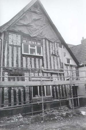
The gable end of Church Farmhouse in Blo Norton. The farmhouse is a grand example of an early 16th century timber framed house. (©NCC)
Although the village is thought to have origins in the Saxon period again there are few finds to back this up. Metal detecting has led to the recovery of a Middle Saxon brooch (NHER
21118) and fieldwalking has recovered a small number of Middle and Late Saxon pottery fragments (NHER
20038). In contrast to the lack of evidence for pre medieval activity there is a wealth of information for the medieval period. The Domesday Survey recorded four manors in the parish – three of these can be identified. Blo Norton Hall (NHER
10916) is a 16th century building but is surrounded by a 13th century moat, and is the site of an early manor. The site of Seymer’s Hall (NHER
10918) is marked on early Ordnance Survey maps, but the building burnt down before 1585. Church Farmhouse (NHER
20144) is a large important 16th century building that may have replaced another of the manors identified in the survey. It has been suggested as the site of Seymer’s Hall, but this contradicts the evidence from Ordnance Survey maps. The medieval settlement at Blo Norton must have been large. Part of it can be seen as the earthworks of a deserted medieval village (NHER
12983) near Blo Norton Hall. This large village supported two churches in a single churchyard until the Black Death. After the dramatic fall in population caused by the plague both churches couldn’t be supported and the Bishop gave permission for St Margaret’s (NHER
10920) to be demolished in May 1394. The site of the church is close to St Andrew’s (NHER
10921), but there are no remains left. The remaining parish church is broadly 13th century in date.
The settlement continued to develop in the post medieval period and there are several good examples of 17th century architecture amongst the village buildings including Elm Cottage (NHER 31158), Manor Farmhouse (NHER 37079) and the Old Smithy (NHER 17631). The village also had its own windmill (NHER 16413), although its exact location is still debated. More unusually the village also contains some listed clay lump council houses (NHER 41208) that were built in the 1920s as an experiment in cheap housing and a railway carriage (NHER 31721) that is used as a shed.
Megan Dennis (NLA), 3rd August 2005.
Further Reading
Blo Norton Parish Council, 2004. ‘Blo Norton Parish Council’. Available:
http://www.blo-norton-pc.gov.uk/home.htm. Accessed 26 January 2006.
Brown, P. (ed.), 1984. Domesday Book, 33 Norfolk, Part I and Part II (Chichester, Philimore)
Mills, A.D., 1998. Dictionary of English Place Names (Oxford, Oxford University Press)
Rye, J., 2000. A Popular Guide to Norfolk Place-names (Dereham, The Larks Press)