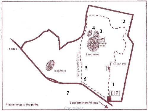
A map of the East Wretham Heath Nature Reserve Heritage Trail.
Take a walk around this beautiful Breckland heath and wetland nature trail and discover a Mesolithic flint working site, an earthwork excavated in the 1930s and a World War Two airfield. The walk is just under two miles long.
The nature reserve was acquired by Norfolk Wildlife Trust in 1938 and was the first nature reserve to be established in Breckland. Park at the nature reserve and follow the green trail. Please keep to the paths.
1. Bronze Age chisel - NHER 5979
In the area to the right of the path a Bronze Age copper alloy chisel was found in the 1930s.
2. World War Two airfield - NHER 35602
This grass airfield was one of many constructed and rushed into service during the early months of 1940, and was initially a satellite station for Honington in Suffolk. Living conditions were at first primitive, and the ground was on occasions so muddy it was likened to 'the Somme without the trenches'. The station was first home to a Czech squadron flying Wellington bombers on raids over Europe. In 1942 it became a satellite of Mildenhall, still with Wellingtons, though these were replaced by Lancaster bombers in 1943. From October 1943 until the end of the war, the station was the base of the 359th USAAF Fighter Group, who flew P-47D Thunderbolts, and later P-51 Mustangs on escort, dive bombing and strafing missions, eventually providing air support for the D-Day landings and the Battle of the Bulge. After the war the station became a Polish resettlement camp. Much of the land was sold off in the 1950s and returned to agriculture, but some of the original huts, the most complete set of World War Two prefabricated buildings in the country, are still used by troops on exercise in the nearby Stanford Battle Area. The station's defences include the very rare survival of an all-round defensive position with four pillboxes surrounding a small area.
3. Roman pot - NHER 5981
Several large pieces of Roman pot were found on the edge of the mere in 1932. These include a piece of high status decorated Samian pot.
4. Prehistoric burnt mound - NHER 5989
A ridge of prehistoric burnt flints was identified running away south from the mere. These flints may be part of a burnt mound - a mound of fire-cracked stones, normally accompanied by a trough or pit which may have been lined with wood, stone or clay. The heated stones may have been used to boil water in the trough.
5. East Harling Drove - NHER 5435
Part of a possible prehistoric trackway running from east to west, sections of which were in use up to the post medieval period. The remains of the trackway are fragmentary, and the subject of continuing discussion. Some of the route is under modern metalled roads.

Mesolithic flints found at East Wretham.
6. Mesolithic flint working site - NHER
5971A large number of worked Mesolithic flints were found north and south of the Harling Drove Road between 1912 and 1913. These included scrapers, flakes and cores that are left after these tools were produced.

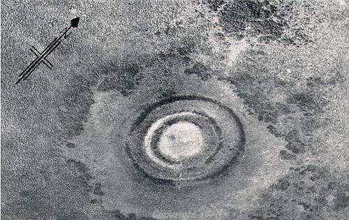
Aerial photograph of an undated earthwork in East Wretham.
7. Undated earthwork - NHER
5977Earthwork of two banks with external ditches. The banks are around 30m diameter and stand around 1m high. Although this earthwork was excavated in the 1930s the excavations revealed no archaeological material to reveal its purpose or date.
M. Dennis (NLA), 7 March 2007.