This Parish Summary is an overview of the large amount of information held for the parish, and only selected examples of sites and finds in each period are given. It has been beyond the scope of the project to carry out detailed research into the historical background, documents, maps or other sources, but we hope that the Parish Summaries will encourage users to refer to the detailed records, and to consult the bibliographical sources referred to below. Feedback and any corrections are welcomed by email to heritage@norfolk.gov.uk
Rollesby is a small parish in the east of the county, close to the town of Great Yarmouth. The small village of Rollesby is in the centre of the parish, and the eastern parish boundary runs through the middle of Rollesby and Ormesby Broads. The name Rollesby comes from the Old Scandinavian meaning ‘farmstead or village of a man named Hroflr’, one of a number of place-names in the area derived from Scandinavian sources.
The earliest archaeological finds from the parish are Neolithic flint implements (NHER 8530) and a Neolithic polished axehead (NHER 11399). Fragments of Beaker pottery (NHER 8531) and a Bronze Age stone axe-hammer (NHER 8532) have also been found. The cropmarks of several ring ditches (NHER 18394, 40655, 38636) have been recorded from aerial photographs. A trackway of post medieval date (NHER 44897) is visible as a cropmark on aerial photographs. Although the trackway is of relatively recent date it may have its origins in the prehistoric period, as it is aligned with other prehistoric trackways in the area.
So far, no evidence from the Iron Age has been found, but a Roman brooch (NHER 28981), fragments of pottery (NHER 28981, 34986), and a coin (NHER 37560) have been found in the parish.
An Early Saxon wrist clasp (NHER 41927) and a Late Saxon stirrup mount (NHER 37560) are the only archaeological evidence from the Saxon period. The Domesday Book records several holdings for Rollesby, including salthouses, woodland, meadows and several plough teams.

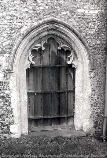
The 14th century south door at St George's Church, Rollesby. (© NCC)
St George’s Church (NHER
8556) dates mainly to the 14th century but has the base of a 12th century round tower. The church has a good example of a cusped south doorway, and includes a number of 19th century alterations. Inside there is a chest tomb to Rose Claxton, who died in 1601, with a reclining effigy in Elizabethan dress, and an early 17th century wall memorial to the Mapes family of Rollesby Hall. Rollesby Broad (NHER
13509) is the remains of a series of medieval peat cuttings that flooded in the late medieval to early post medieval period to form broads. A number of possible medieval boundary ditches (NHER
39194) are visible as cropmarks on aerial photographs. Medieval finds from the parish include fragments of pottery (NHER
8569,
28981), a gold ring (NHER
8533), a harness mount (NHER
18120), a gold coin (NHER
19661) and an ampulla from the shrine at Walsingham (NHER
36235).
Rollesby Hall (NHER 8551) was built in the mid 16th century. The house was extended in the early 17th century by Leonard Mapes, who is buried in St George’s Church, and again in the early 19th century when the whole house was refronted in white brick. The hall was demolished in the 1950s and only a small length of 18th or 19th century garden wall and some outbuildings survive from the original hall. A new house has now been built next to the site.
Old World Cottage on Fleggburgh Road (NHER 14965) is a late 16th century brick house with a thatched roof and a datestone bearing the date 1583. Church Farm (NHER 14966) is a late 16th century brick and thatched farmhouse. The house has a door with a 16th century moulded timber surround and original ovolo moulded windows. Close to the house is a late 18th century brick barn, and there was also a 16th century timber framed aisled barn with brick infill added in the 18th century, which collapsed in 1996 or 1997. White House Farm (NHER 12101) is a 17th century farmhouse with an 18th century façade and a thatched roof. The east front of the house has three ovolo-moulded mullion windows. The Old Court House (NHER 14967) is a former workhouse that was built in the late 18th century, and enlarged in the early 19th century before being partially burnt down in 1836. During the late 19th and early 20th century the building was used as a court house, and it is now a hotel. Over the door is a plaque bearing the inscription 'For the INSTRUCTION OF YOUTH, the ENCOURAGEMENT of INDUSTRY, the RELIEF of WANT, the SUPPORT of OLD AGE, and the COMFORT of INFIRMITY and PAIN'. The barn at Sewells Farm (NHER 42897) is an 18th century brick barn and stables with a thatched roof. Hall Farmhouse (NHER 42898) is a mid 18th century brick farmhouse with a thatched roof. The house has sash and dormer windows and the façade is decorated with pilasters.
Sarah Spooner (NLA), 1 August 2006.
Further Reading
Brown, P. (ed.), 1984. Domesday Book: Norfolk (Chichester, Phillimore)
Mills, A. D., 1998. Dictionary of English Place-Names (Oxford, Oxford University Press)
Rye, J., 1991. A Popular Guide to Norfolk Place-names (Dereham, Larks Press)
Norfolk Federation of Women’s Institutes, 1990. The Norfolk Village Book (Newbury, Countryside Books)