This Parish Summary is an overview of the large amount of information held for the parish, and only selected examples of sites and finds in each period are given. It has been beyond the scope of the project to carry out detailed research into the historical background, documents, maps or other sources, but we hope that the Parish Summaries will encourage users to refer to the detailed records, and to consult the bibliographical sources referred to below. Feedback and any corrections are welcomed by email to heritage@norfolk.gov.uk
East Tuddenham, from the Old English meaning ‘homestead or village of a man called Tuda’, is to the west of Norwich, and the parish is cut through by the A47.
Some prehistoric flint implements (NHER 7301) have been found in the parish, including Neolithic axeheads (NHER 7302, NHER 16098), and Neolithic and Bronze Age flakes, cores and blades (NHER 29435). Bronze Age axeheads (NHER 11536 and 31686) and the tip of a Late Bronze Age sword (NHER 35238) have also been found, as well as prehistoric (NHER 17837) and Beaker pottery (NHER 7300), and prehistoric pot boilers (NHER 30199). However, no prehistoric settlement sites have yet been identified.
An Iron Age and Roman settlement (NHER 29435) has been identified in the southwest, and large amounts of Iron Age and Roman pottery and coins have been found on the site by metal detecting. Metal detecting has recovered a gold Iron Age coin, Roman coins and Roman pottery (NHER 25718) from a site close to that of the settlement (NHER 29435). An Iron Age toggle (NHER 31498) has been found close to the remains of a Roman building (NHER 7304), which had a hypocaust. Roman coins (NHER 25767 and 31042) a brooch (NHER 25767), and pottery (NHER 31042) have been found scattered throughout the parish.
Two Early Saxon brooches (NHER 34884 and 25965) have been found, as well as a Late Saxon disc brooch (NHER 31042). Middle Saxon and Late Saxon pottery (NHER 14686) and a 9th century strap end (NHER 25674), decorated with niello and silver wire, have been found close to All Saints’ Church (NHER 7314). This could suggest that the original focus of settlement in the Saxon period was in the area around the church, and it slowly gravitated towards the edge of the common during the medieval period. In Domesday Book, East Tuddenham is recorded as a relatively small settlement with a church, divided between several manors.

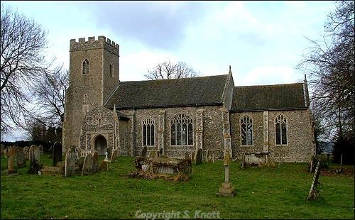
All Saints' Church, East Tuddenham. Photograph from www.norfolkchurches.co.uk © S. Knott
All Saints’ Church (NHER
7314) has no surviving evidence of such an early building, and dates from the 13th century. The church contains an early 13th century font and a 13th century tomb effigy. The possible site of another medieval church (NHER
19183) has been discovered at the edge of the parish. In the 1980s medieval masonry was discovered on a site marked as North Tuddenham church on a mid 18th century map. The site of a possible medieval moat (NHER
7315) is at the edge of the common, and a watching brief carried out by the Norfolk Archaeological Unit in 2000 revealed medieval and post medieval ditches and pottery, which may have been associated with the moated site. An area of medieval ridge and furrow (NHER
30408) is visible near the parish boundary on infrared aerial photographs; perhaps the edges of the medieval open fields in the parish. East Tuddenham continued to be an agricultural parish throughout the medieval and post medieval periods.
The Old Hall (NHER 13158) is a 16th and 17th century hall, with a gabled porch and moulded brick windows. The nearby timber framed barn (NHER 13158) also dates from the 17th century. The site of a medieval or post medieval dovecote (NHER 16566) is associated with the Old Hall (NHER 13158), and was recorded as being near the ‘Hall Gate’ in the 18th century. Mockbeggar Hall (NHER 20557) is an early 17th century building, with late 17th century outbuildings, a garden wall and a dovecote. The dovecote is now used as a water tower, but the interior retains its original nesting boxes. The unusual name is thought to date from the 18th or 19th centuries, when the Hall was in a state of disrepair and was lived in by poor labourers. Harrison’s Farm (NHER 31198) is a 16th century farmhouse, which was extended in the 17th century. Walnut Tree Farm (NHER 13151) is an early 18th century farmhouse, with a hexagonal porch tower and chequered brickwork.

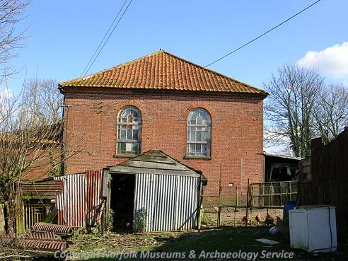
Old Moor Chapel, East Tuddenham. (© NCC.)
During World War One a military airfield (NHER
13620) in Mattishall and East Tuddenham was used as a night landing ground. Attlebridge airfield covers part of the north of the parish, and a survey of the airfield in 2004 recorded World War Two barracks (NHER
40733 and
40734), an officers’ quarters (NHER
40738), a fuel store (NHER
40736), a generator house (NHER
40737), and air raid shelters (NHER
40735 and
41909).
Sarah Spooner (NLA), 8 November 2005.
Further Reading
Brown, P. (ed.), 1984. Domesday Book: Norfolk (Chichester, Phillimore)
Mills, A.D., 1998. Dictionary of English Place-Names (Oxford, Oxford University Press)
Rye, J., 1991. A Popular Guide to Norfolk Place-names (Dereham, Larks Press)