This Parish Summary is an overview of the large amount of information held for the parish, and only selected examples of sites and finds in each period are given. It has been beyond the scope of the project to carry out detailed research into the historical background, documents, maps or other sources, but we hope that the Parish Summaries will encourage users to refer to the detailed records, and to consult the bibliographical sources referred to below. Feedback and any corrections are welcomed by email to heritage@norfolk.gov.uk
Bintree is a small parish in the centre of Norfolk to the north of Billingford and just southwest of Foulsham. Located in the Breckland area it includes the small villages of Bintree and Twyford. The origins of the villages are unknown. The first mention of Bintree is in the Domesday Book. The village name may be translated as “the tree of the man known as Bynna”. The parish is particularly rich in surface finds of prehistoric flint tools and weapons and there is evidence for Roman settlement, an Early Saxon cemetery and some interesting medieval and post medieval archaeology.
The prehistoric period is characterised by some exciting surface finds. The earliest is a Palaeolithic handaxe (NHER 7193) but there is also evidence for human activity in the later prehistoric periods. A Mesolithic macehead (NHER 24923), Neolithic chisel (NHER 7194), Neolithic arrowhead (NHER 21131) and a Neolithic scraper (NHER 41314) were all found in the parish. There are also prehistoric monuments – there are at least two Bronze Age barrows in the parish. These are of two different forms. An oval barrow (NHER 2912) was found near the County School site, and was later used as a semaphore station. A more usual Bronze Age ring ditch (NHER 35937) has been identified from aerial photographs. A recent plantation of trees now disguises half of this monument.
In the Iron Age we continue to see evidence for occupation and activity. Iron Age pottery (NHER 34150) is evidence that people lived in the area and the possible Iron Age rectangular enclosure (NHER 12147) may have been used for defence or as a ritual site. This rectangular site used to be interpreted as a Roman signal station, but this is now thought to be unlikely. There is other evidence in the parish for the Roman period, however, including Roman coins (NHER 14683) and pottery. On one site high quality, exotic samian pottery (NHER 7195) has been recovered. The proximity of the Roman road and settlement site at Billingford (NHER 7206) suggest that there may have been Roman activity in the area and at one site large numbers of Roman coins and metal objects have been interpreted as a possible Roman settlement (NHER 31119). An aerial photograph has shown rectangular house platforms (NHER 33536) on Bintree Common that may date to the Roman period.
There is also evidence for a possible Early Saxon cemetery (NHER 31119) at a site where several Early Saxon brooches, a girdle hanger and a strap fitting have been found. Other finds from the Saxon period are a Middle Saxon pin (NHER 35911) and a Late Saxon box mount (NHER 28471).

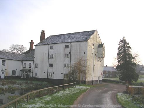
Bintree Mill, an 18th century watermill set over a stream. (©NCC)
St Swithin’s church (NHER
7219) dates broadly to the 14th century although there are Norman elements within the architecture. Bintry Mill (NHER
2932), although built in the 18th century, is on the site of an earlier mill recorded dated to 1454. The house platforms (NHER 33536) on the common may be medieval in date. There are many examples of post medieval architecture from the parish. The earliest domestic structure dates to the 16th century but only the east gable survives and has been integrated into the later 18th century Draw Water Cottage (NHER
30268). Manor House Farm (NHER
21225) is not a manor house but a 17th century farmhouse built by Holkham estate around an earlier 16th century building. The post medieval whipping post (NHER
21224) still survives on the green.

The 19th century buildings of the Norfolk County School which later became Watts Naval Training School.
More modern sites include the old County School site (NHER
2934). These 19th century buildings were used as the Norfolk County School and were then converted into Watts Naval Training School. They have now mostly been demolished. Dating to the same period, when the training school was used, a semaphore station (NHER
2912) was constructed on top of the earlier Bronze Age barrow. Undated clay and marl pits (NHER
41075) seen from aerial photographs were probably quarried out during the 19th century.
Megan Dennis (NLA), 2nd August 2005.
Further Reading
Brown, P. (ed.), 1984. Domesday Book, 33 Norfolk, Part I and Part II (Chichester, Philimore)
Mills, A.D., 1998. Dictionary of English Place Names (Oxford, Oxford University Press)
Neville, J., 2003. ‘Norfolk Mills – Bintree watermill’. Available:
http://www.norfolkmills.co.uk/Watermills/bintry.html. Accessed: 26 January 2006.