This Parish Summary is an overview of the large amount of information held for the parish, and only selected examples of sites and finds in each period are given. It has been beyond the scope of the project to carry out detailed research into the historical background, documents, maps or other sources, but we hope that the Parish Summaries will encourage users to refer to the detailed records, and to consult the bibliographical sources referred to below. Feedback and any corrections are welcomed by email to heritage@norfolk.gov.uk
Melton Constable is a small parish in the north of the county. The landscape of the south of the parish is dominated by the landscape park that surrounds Melton Constable Hall, and to the north is the 19th century railway town of Melton Constable and the lost village of Burgh Parva. Burgh comes from the Old English meaning ‘a fortification or stronghold’. Melton is usually taken to mean ‘middle farmstead’, but in this case it may mean ‘farmstead with a crucifix’. The manorial affix is derived from the possession of the manor by the constable of the Bishop of Norwich in the 12th century.

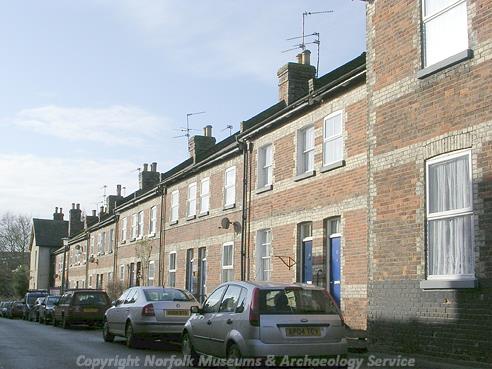
A street in the planned railway town of Melton Constable. (© NCC)
The earliest archaeological finds from the parish are Neolithic flint implements (NHER
3220) including two Neolithic flints axeheads (NHER
17456,
34498). A ring ditch (NHER
36777), probably the remains of a Bronze Age barrow, is visible as a cropmark on aerial photographs to the east of the park. A Bronze Age awl (NHER
3221) and a palstave (NHER
19732) have been found in the parish. Metal detectorists have also found Iron Age and Roman pottery (NHER
3228) and brooches (NHER
3232,
37559).
In 1086 Melton was held by the bishop of Thetford, and the Domesday Book records 4 freemen, 2 villagers and 32 smallholders, as well as woodland for 60 pigs, 8 head of cattle and a church with 6 acres. The Late Saxon and medieval village of Melton may have been relatively big, and a Late Saxon strap-end (NHER 24010) and a hooked tag (NHER 37559) have been found during metal detecting. Burgh Parva (NHER 3232) was gradually deserted over the medieval period, and the only remains of the settlement are the ruins of St Mary’s Church. The west tower and fragments of the nave and chancel walls are still upstanding. The presence of large conglomerate blocks in the surviving parts of the church suggests an 11th or 12th century date, and there is also a blocked splayed window in the south wall of the nave. The church was consolidated with St Peter’s in Melton in the 16th century, and the church fell into ruins.
A series of very slight earthworks (NHER 30287) are visible in the area to the south of Melton Constable Hall. The earthworks include the remains of a possible medieval hollow way and other settlement earthworks, as well as field boundaries. The cropmarks of an area of deserted medieval settlement (NHER 3228) are visible on aerial photographs to the south of St Peter’s Church. Metal detecting has recovered a Late Saxon coin from the reign of King Harold, and fragments of Late Saxon and medieval pottery have been found on the site. Other possible medieval settlement or field system earthworks (NHER 3230) have been recorded to the south of Dairy Farm.
St Peter’s Church (NHER 3247) is a wonderful Late Saxon or Norman church with a central tower. The church may date from before the Conquest, and inside the chancel arch is surmounted by a huge double arch, which is separated by a massive circular pier. The church also has a medieval wooden shutter in one of the windows on the south wall. Next to the shuttered window is an original alcove seat and book rest. The south transept of the church is used as the mausoleum of the Astley family, and contains many of their memorials.
The Astley family have been Lords of the Manor of Melton since the 13th century, and the moated site of their medieval manor house (NHER 3229) has survived within the landscape park that surrounds the later Hall. The empty moat is shown on an estate map of 1674, as the manor house was demolished before work began on the new Hall. A medieval deer park may have been in existence since the 13th century, and the 1674 map shows a series of ponds to the north of the park, suggesting that the manor house was surrounded by a designed landscape long before the elaborate gardens of the new Hall were laid out.
Work on Melton Constable Hall (NHER 3241) was completed in about 1687, and the house is a nationally important example of a late 17th century country house in the Domestic-Classical style that was heavily influenced by the architecture of the Netherlands. The house contains original late 17th century plasterwork as well as a detailed Greek Revival ceiling dating to about 1820. The Hall fell into neglect in the mid 20th century and is now undergoing a gradual programme of restoration to bring it back to its former glory.
The Hall is the only Norfolk house included in Kip and Knyff’s ‘Britannia Illustrata’ that was published in 1707. The aerial view of the Hall shows the large and elaborate formal gardens around the house, which included elements of an earlier formal landscape shown on the estate map of 1674. The late 17th century gardens (NHER 30472) were designed around a series of enclosures filled with formal planting, elaborate parterres, an ornamental canal, fountains, a series of four large fishponds, and garden buildings. The gardens were set within a park that had a number of avenues radiating out from the house. The western avenue was focused on a standing, or hunting tower, now known as the Bath House (NHER 3243). The gardens are also depicted in a series of early 18th century illustrations by Edmund Prideaux. These formal gardens survived until the early 18th century, but they had disappeared by 1741. In 1764 Lancelot 'Capability' Brown was employed to carry out improvements to the park (NHER 30472). Brown levelled much of the area around the hall, including two of the late 17th century fishponds to the north of the Hall. Brown also created the lake, planted perimeter belts, Gothicised the Bath House and provided designs for several other garden buildings. In the 1840s or 1850s a terraced Italianate garden was laid out around the Hall, with balustrades, steps and fountains. The Teahouse (NHER 44532) is an early 18th century weather-boarded building with a slate roof. Swanton Lodge (NHER 17712) and Church Lodge (NHER 44531) are two early 19th century gate lodges, with cast iron gates and brick gate piers. Both lodges have wooden porticos with pairs of columns.
Burgh Hall (NHER 3240) is a complex building that dates back to the late 16th century. Several different phases of building work can be traced in the fabric of the building, which was heightened and extended in the 17th century. The east wing was added in about 1700, and the barn and other farm buildings were also built in the early 18th century. In the early 19th century the north wing was added. The severe facade of this wing has large windows and brick pilasters, and originally had a flat roof with a parapet. Nursery Cottages (NHER 3246) are a terrace of 18th century red brick cottages with a central brick pediment. The cottages were originally built as a workhouse, and are marked as such on Faden’s map of 1797. Dairy Farm (NHER 19780) is a group of 18th and 19th century farm buildings, including a mid 19th century Tudor-style dairy and an octagonal game larder. Stud Farm Cottages (NHER 44530) are a pair of early 19th century cottages, with a central three-storey tower flanked by single bay wings. The cottages are similar in style to Samuel’s Wyatt’s designs for the Holkham Estate.

Melton Constable station. © Eastern Daily Press.
In the 1880s Burgh Parva and Melton Constable became ‘the railway capital’ of Norfolk almost overnight! The Midland and Great Northern Railway opened in 1885, and a huge depot was located in the parish. With the sudden influx of people into the parish a new church was required, as the medieval ruins of St Mary’s Church were not suitable for services. A temporary corrugated iron church (NHER
3232) was erected and was consecrated in 1903. A competition was held to design a new permanent church, but a winning design could not be found, and the ‘temporary’ church is still being used for services.

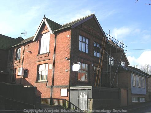
Melton Constable Railway Institute. (© NCC)
Melton Constable itself is a planned railway town (NHER
13583), and is an unspoilt example of Victorian planning. The town was provided with a school, shops, pubs, a Working Men’s Club and a station. The original town was laid out around two red brick terraced streets, and later developments sprang up in the late 19th century.
Sarah Spooner (NLA), 12 May 2006.
Further Reading
Brown, P. (ed.), 1984. Domesday Book: Norfolk (Chichester, Phillimore)
Mills, A. D., 1998. Dictionary of English Place-Names (Oxford, Oxford University Press)
Pevsner, N. and Wilson, B., 1997. The Buildings of England: Norfolk 1: Norwich and North East (London: Penguin)
Rye, J., 1991. A Popular Guide to Norfolk Place-names (Dereham, Larks Press)
Williamson, T., 1998. The Archaeology of the Landscape Park: Garden Design in Norfolk c1680-1840 (BAR British Series No 268)