This Parish Summary is an overview of the large amount of information held for the parish, and only selected examples of sites and finds in each period are given. It has been beyond the scope of the project to carry out detailed research into the historical background, documents, maps or other sources, but we hope that the Parish Summaries will encourage users to refer to the detailed records, and to consult the bibliographical sources referred to below. Feedback and any corrections are welcomed by email to heritage@norfolk.gov.uk
Kilverstone is a small parish in Breckland on the edge of the town of Thetford. The River Thet forms the southern boundary of the parish, and to the north the parish is bisected by the A11 and the railway. Kilverstone comes from the Old English meaning ‘Kilvert’s enclosure or settlement’.
An excavation carried out on the site of an Asda store on Norwich Road by the CAU in 2000 revealed a nationally important Early Neolithic site made up of over two hundred pits, some of which were grouped into distinct clusters (NHER 34489 and 37349). The pits are probably the remains of an Early Neolithic settlement. A small group of Beaker pits and a Late Neolithic to Early Bronze Age 'buried soil' deposit, both containing pottery and flints were also discovered (NHER 25763). Other prehistoric finds from the parish include Early Neolithic pottery (NHER 37694) and Neolithic flints (NHER 5947) including arrowheads (NHER 5946, 5948), an adze (NHER 11483), a knife (NHER 14794) and axeheads (NHER 14795, 14796). Two ring ditches (NHER 12167, 13493), probably the remains of Bronze Age round barrows, are visible as cropmarks on aerial photographs to the north of Kilverstone Hall. A Bronze Age spearhead (NHER 5978) and the blade of a chisel (NHER 28608) have been found.

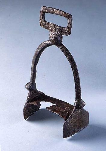
An iron and inlaid brass stirrup from the River Thet in Kilverstone. The stirrup may date to the Roman, Late Saxon or medieval period. NWHCM 1836.58.1:A (© NCC)
The CAU excavation also revealed an Iron Age to Roman settlement. A series of Late Iron Age ditches and a post-built structure was replaced in the Early Roman period by a more extensive system of ditches, and by the end of the 2nd century AD the settlement included a timber aisled barn and other post-built structures. The excavation uncovered three circular late Roman structures that were associated with metalworking. One structure contained a wooden pump, one of only two examples to be excavated in Britain. A blacksmith's hoard, including an anvil, tongs, and several pewter plates, was found in a pit on the site (NHER
34489). An Iron Age or Roman escutcheon from a bucket (NHER
34491) has been found by a metal detectorist, as well as Roman pottery (NHER
28482,
36161), coins (NHER
28482,
28759), brooches (NHER
22209,
28487,
28729) and other metal finds.
The excavation also revealed a small Early Saxon settlement (NHER 34489), with ten sunken-featured buildings and four post-built halls. The settlement is associated with a nearby Early Saxon cemetery (NHER 37349). The cemetery contained six inhumations and a cremation. An Early Saxon wrist clasp (NHER 17268), fragments of Early Saxon pottery (NHER 37694), a Middle Saxon silver sceat (NHER 17270), a Middle Saxon cross brooch (NHER 24173), Late Saxon pottery (NHER 5905) and a coin from the reign of Cnut (NHER 17270) have been found during fieldwalking and metal detecting.
In 1086 Kilverstone was held by the King and by Robert Malet, and the Domesday Book records mills, a fishpond and flocks of sheep. Medieval and post medieval documents show that sheep were of enduring importance in the local economy, and the cause of many legal disputes!
St Andrew’s Church (NHER 5950) has a 12th century round tower, and parts of the nave and chancel also date to the 12th century. The church was altered in the 14th century and was restored by Boardman in 1906. The medieval village of Kilverstone (NHER 5952) was virtually deserted when a small landscape park was laid out around Kilverstone Hall in the late 18th century. The earthworks of medieval hollow ways, tofts and house platforms are visible on aerial photographs taken in 1946, but the earthworks have since been destroyed by ploughing. Fieldwalking on the site has recovered Roman, medieval and post medieval pottery. There were two manorial sites in the villages, Coxford’s and Monk’s Hall. Both manors were in ecclesiastical hands until the Dissolution, and by the end of the 16th century both manors were held by Thomas Wright. Medieval pottery (NHER 5905), coins (NHER 13494, 17270, 29445, 34419), a brooch (NHER 32220) and other metal finds (NHER 36161) have been found, including a 14th century seal made from a Roman coin (NHER 17268) that belonged to John Cornwallis, whose descendants were Lords of the Manor of Coxford in the 16th century.

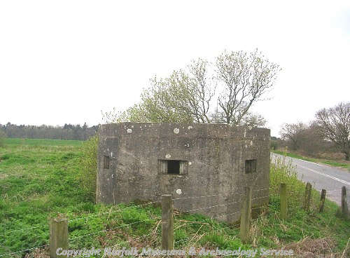
A World War Two pillbox guarding a level crossing. (© NCC)
Kilverstone Hall (NHER
5951) is an early 17th century house that was extensively rebuilt in the Jacobean style in 1913. The drawing room and dining room have been virtually unaltered since the early 18th century, and both rooms contain ornate fireplaces. The stables (NHER
44280) were designed by Boardman in 1901, with a open loggia and a clocktower. Boardman also designed the entrance lodge (NHER
44278) and the water tower, which has decorative brickwork and a timber tank.
During the 1840s a large number of huts (NHER 5010) were erected on Kilverstone Heath to house people working on the construction of the railway. A World War Two pillbox (NHER 15052) guards a level crossing on the railway.
Sarah Spooner (NLA), 8 May 2006.
Further Reading
Brown, P. (ed.), 1984. Domesday Book: Norfolk (Chichester, Phillimore)
Davison, A., 1988. Six Deserted Villages in Norfolk (East Anglian Archaeology Report No 44)
Mills, A. D., 1998. Dictionary of English Place-Names (Oxford, Oxford University Press)
Rye, J., 1991. A Popular Guide to Norfolk Place-names (Dereham, Larks Press)