This Parish Summary is an overview of the large amount of information held for the parish, and only selected examples of sites and finds in each period are given. It has been beyond the scope of the project to carry out detailed research into the historical background, documents, maps or other sources, but we hope that the Parish Summaries will encourage users to refer to the detailed records, and to consult the bibliographical sources referred to below. Feedback and any corrections are welcomed by email to heritage@norfolk.gov.uk
Bagthorpe with Barmer is situated in west Norfolk, to the east of Bircham. It was originally two separate parishes, each of which were mentioned in the Domesday Book as belonging to William of Warenne, one of William the Conqueror’s supporters. Prior to the Norman Conquest the lands were owned by a Saxon called Toki. The name Bagthorpe is from Old Scandinavian for ‘Bakki’s farmstead or hamlet’. The name Barmer is Old English for ‘pool of a man called Bera’ or, more interestingly, could mean the ‘pool frequented by bears’. The two villages straddle the B1454, Barmer being to the north east of it and Bagthorpe to the southwest.
The earliest evidence of occupation in the parish comes in the form of a Palaeolithic flint flake found in the southeast part of Barmer village. Later Stone Age artefacts from the parish are a Neolithic flint axe hammer found west of Bagthorpe village and a flint knife. Occupation in the Bronze Age is indicated by a possible round barrow (burial mound) known as Crab’s Castle (NHER 1989) which is located to the north of Barmer village. Also a Bronze Age barbed and tanged arrowhead has been found.
Evidence from the Roman period is scant in the parish and is confined to some pottery fragments and a single coin, all of which were found north of the B1454. Likewise, post Roman evidence of habitation consists only of a scatter of Late Saxon pottery.

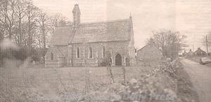
St Mary's Church, Bagthorpe, which was rebuilt in Early English style in the 1850s. (©NCC)
The medieval period saw the construction of a church in each of the original parishes, St Mary’s in Bagthorpe (NHER 1725) and All Saints’ in Barmer (NHER 1990). Although originally medieval, St Mary’s was completely rebuilt in 1853/1854. All Saints’ has a 12th century tower and nave with a 14th century north aisle, but the remainder is a rebuild from 1885. Metal detecting in recent years has recovered a medieval buckle.
From the post medieval period there are several surviving buildings. Probably the oldest of these with a definite date is Barmer Farm Barn, built in 1754. Interestingly, this is located on the site of an unknown deserted medieval village that was identified by aerial photography in 1991. Bagthorpe Farm is also 18th century. Maps of the time show a saw pit northeast of Bagthorpe (nothing now remains). Bagthorpe Hall, a late 18th or early 19th century mansion, was demolished after World War Two although the old cellars and icehouse can still be seen. Lastly, Bryant’s map of 1826 marks a brick kiln north east of Bagthorpe, although there is nothing to see today.
Pieter Aldridge (NLA), August 2005.