This Parish Summary is an overview of the large amount of information held for the parish, and only selected examples of sites and finds in each period are given. It has been beyond the scope of the project to carry out detailed research into the historical background, documents, maps or other sources, but we hope that the Parish Summaries will encourage users to refer to the detailed records, and to consult the bibliographical sources referred to below. Feedback and any corrections are welcomed by email to heritage@norfolk.gov.uk
Flordon is a small parish located in south Norfolk. It lies directly to the east of Newton Flotman, to the southeast of Wymondham and is south of Norwich. Two groups of housing form Flordon village; they are sited in the southeast of the parish, alongside the Newton Flotman to Bracon Ash road. The Norwich to London railway line passes through the eastern part of the village. A few farms and small clusters of houses are scattered elsewhere.
Little archaeological work has been carried out in Flordon. Most reported artefacts have been discovered by accident and there is only one recorded metal detecting site. Only a few sites have been identified from aerial photographs and no excavations have taken place. The result of this is that little is known about past settlement and activity. Nonetheless, a few details can be presented.
Prehistoric flint artefacts have been found at four sites. They include a Neolithic core and Neolithic scraper. Prehistoric pot boilers (NHER 9987) have been found at a site in the east of the parish. They may indicate the location of a prehistoric burnt mound. Two ring ditches (NHER 36348) are visible on aerial photographs of the north of the parish. A third possible ring ditch (NHER 11679) has been identified in the west. All three could be the remnants of Bronze Age barrows.
Roman artefacts have been found at two sites in the south of the parish. A sherd of samian ware was discovered at one site, while in July 1997 a metal detectorist found a late 2nd/early 3rd century coin (NHER 32910). The only Saxon artefact from the parish is a possible Early Saxon spear head (NHER 9966) recovered from a site in the southeast. Human remains recovered from a gravel pit in the 1960s, 1970s and 1980s could be Saxon or medieval in date.

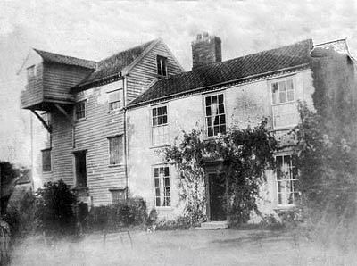
Flordon watermill around 1906. Photograph from www.norfolkmills.co.uk
Flordon is recorded in the Domesday Book of 1086 as ‘Florenduna’. This is an obscure placename that may mean ‘the hill with a tessellated floor or pavement’. In 1086 land in the parish was held by the Bishop of Bayeux, Count Alan, Roger Bigot and Godric the Steward. Some of the land was held as outliers of estates at Costessey and Hethel. A mill is mentioned and this may have stood on the site of Flordon Mill (NHER
9966), a post medieval watermill that was demolished in the late 20th century.
St Michael’s Church (NHER 9997) stands in Flordon village and is a medieval and post medieval church. The earliest section dates to the 11th or 12th century and may include Late Saxon windows. It was extended during the 14th century. There was once a round western tower; a 19th century brick bell cote stands in its place. A 14th or 15th century brooch (NHER 9965) has been found to the east of the church.
In 1086 a settlement called ‘Rainthorpe’ was recorded in the Domesday Book. It was held by Roget Bigot and Roger of Raismes and may have been located in the east of Flordon parish, close to where Rainthorpe Hall (NHER 10110) stands. Rainthorpe Hall was built in 1503 as a brick and timber framed building. It was developed in the later 16th, 17th and 19th centuries and features 16th century plasterwork, 13th to 19th century window glass and a wind vane that may be 17th century in date. A post medieval landscape park (NHER 30483) surrounding the hall includes terraces, a ha ha and a kitchen garden.
Flordon Hall (NHER 18323) is a late 16th or early 17th century timber framed house. A post medieval dovecote (NHER 13741) stands within its ground. To the east of the hall are a post medieval house and barn (NHER 19476). The house was built in around 1600, possibly as a dower house, and is now used as a piggery. The timber framed barn was built during the 17th century.
To the east of the hall a group of undated enclosures, banks and ditches (NHER 9990) are visible as cropmarks on aerial photographs. A windmill (NHER 13768) is shown on Faden's map of 1797 to the south of Flordon village. It was demolished in 1870 and none of the structure survives above ground.
David Robertson (NLA), 29 November 2005.
Further Reading
Barringer, C., 1989. Faden’s Map of Norfolk (Dereham, Larks Press)
Brown, P. (ed.), 1984. Domesday Book: Norfolk (Chichester, Phillimore)
Mills, A.D., 1998. Dictionary of English Place-Names (Oxford, Oxford University Press)
Rye, J., 1991. A Popular Guide to Norfolk Place-names (Dereham, Larks Press)