This Parish Summary is an overview of the large amount of information held for the parish, and only selected examples of sites and finds in each period are given. It has been beyond the scope of the project to carry out detailed research into the historical background, documents, maps or other sources, but we hope that the Parish Summaries will encourage users to refer to the detailed records, and to consult the bibliographical sources referred to below. Feedback and any corrections are welcomed by email to heritage@norfolk.gov.uk
Brettenham is a large parish in Breckland, close to the town of Thetford, in the south of the county. Settlement in the parish is sparse, and focused on the hamlets of Brettenham and Rushford.
Due to the later landscape history of Breckland, which has not been ploughed as intensively as other areas of Norfolk, prehistoric artefacts and sites tend to survive in greater numbers. Palaeolithic handaxes (NHER 5800, 5953), Mesolithic axeheads (NHER 6053), a Mesolithic mace (NHER 13318) and part of a wooden bow or axe (NHER 5967) have been found in the parish, as well as Neolithic flint implements including knives (NHER 6056 and NHER 33659) and arrowheads (NHER 6060). A small Bronze Age settlement (NHER 5955) was excavated by Norwich Castle Museum in 1959 on the banks of the Little Ouse, and the remains of buildings, pits and enclosures were discovered, as well as a substantial amount of Bronze Age pottery. Close to the settlement is a linear barrow cemetery (NHER 5958), known as the ‘Seven Hills’, which was constructed on a ridge of high land above the Little Ouse.
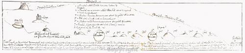
Manuscript plan of 1740 of Bronze Age linear barrow cemetery on Rushford Downs, Brettenham.
Settlement continued to develop in Brettenham during the Iron Age, pottery (NHER
21450,
22012) and coins (NHER
22706,
28109) have been found scattered throughout the parish, as well as a small hoard of silver coins (NHER
6065). The Peddar’s Way (NHER
1289) forms part of the parish boundary of Brettenham, and Roman settlement in the parish seems to have been drawn to the edges of the road, including the site of a possible Roman villa (NHER
15657) and a Roman town (NHER
5653), which straddles the road. Buildings and other features are visible as cropmarks on aerial photographs, and excavation revealed various Roman buildings, and large amounts of pottery and building materials, as well as two Roman coin hoards. Roman inhumations have also been found on the site, which was reused as a cemetery in the Early Saxon period. Another area of Roman and Early Saxon settlement (NHER
17269) is located on the other side of the parish, close to the outskirts of Thetford. The remains of domestic and agricultural buildings dating to both the Roman and the Early Saxon periods have been found, as well as a Late Roman cemetery.

A Roman lead seal impression from Brettenham and Bridgham. (©NCC) NWHCM 1983.305:A
During the Saxon period nucleated settlements developed around the present hamlets of Brettenham, Rushford and Great and Little Snarehill. An Early Saxon cremation cemetery (NHER
6076) was discovered close to the village of Brettenham in the late 17th century, with over 100 burials. In Rushford the Norfolk Archaeological Unit have excavated various Late Saxon settlement features (NHER
40919), including a boundary ditch. All four settlements are recorded in the Domesday Book, but it does not mention the presence of a church at Great Snarehill. The remains of the Late Saxon parish church (NHER
5962) at Great Snarehill have been incorporated into the 18th century outbuildings of Snarehill Hall.
The Domesday Book records the presence of large numbers of sheep in the settlements within the parish, and pastoral farming was the most important element of the agricultural exploitation of Breckland into the post medieval period. The hamlets of Great and Little Snarehill (NHER 5962, 5965) gradually became deserted over the course of the medieval and post medieval periods, and a map of 1740 shows a warrener’s lodge on the site of the hamlet of Little Snarehill. St John’s College (NHER 6092) in Rushford was founded in the mid 14th century, and the church and associated buildings have survived, a rare survival of a collegiate foundation.
The post medieval landscape of the parish is dominated by Shadwell Court (NHER 6090) and Park (NHER 29366). The house dates from the 18th century, but was extensively remodelled in the 19th century in Gothic Revival style, as was the medieval parish church of St Andrew (NHER 6093). The landscape park (NHER 29366) was laid out in the 18th century, with perimeter belts and extensive plantations to provide privacy for the house, as well as game cover. The large lake and the formal gardens (NHER 29364) were created in the 19th century, when the house was altered. The creation of large parks and estates was typical in Breckland in the late 18th and 19th centuries, when improving landowners revolutionised the agricultural landscape of the area.
Snarehill Airfield (NHER 11746) was built during World War One, and continued to be used as a decoy during World War Two. The airfield is close to the Bronze Age settlement (NHER 5955) and barrow cemetery (NHER 5958), a reminder of the rich variety of archaeology from all periods that is juxtaposed in the Breckland landscape.
Sarah Spooner (NLA), 14 September 2005.
Further Reading
Brown, P. (ed.), 1984. Domesday Book: Norfolk (Chichester, Phillimore)
Mills, A.D., 1998. Dictionary of English Place-Names (Oxford, Oxford University Press)
Rye, J., 1991. A Popular Guide to Norfolk Place-names (Dereham, Larks Press)