This parish summary provides an overview of the large amount of information which we hold about the parish, and only a representative sample of sites and artefacts from each period are mentioned. If you have any feedback on this article please contact us using the link on the left-hand menu or by emailing heritage@norfolk.gov.uk
Anmer is a small parish in the northwest of Norfolk which was first recorded in the Domesday Book in 1086. Anmer, meaning ‘duck pool’, was a small settlement, held by a free man named Ordgar before the lands were given to Count Eustace after 1066. The modern settlement is very small and its focus shifted to the east of the site of the medieval village (NHER 3514) in the late 18th century after the creation of the landscape park (NHER 30492) surrounding Anmer Hall (NHER 3512).
Evidence for early occupation is concentrated in the east of the parish around the sites of several Bronze Age barrows (NHER 3518, 3519, 12206 and 3476). A field book of about 1600 refers to these barrows as being ‘on the common’ and names them as Burnt Hill, Ingoe Hill, Rushmere Hill and Threshilles. Axeheads (NHER 1566 and 14527), flakes, scrapers and blades (NHER 11472, 13962, 19503, 30267 and 19504) from the Neolithic period, as well as a Bronze Age adze (NHER 19505) and other prehistoric flints (NHER 19503 and 19504) have been found in this area. This concentration of prehistoric finds and Bronze Age barrows is immediately next to the Peddar’s Way, a Roman road that also forms the eastern boundary of the parish. There is further indication of Bronze Age activity in the adjacent parish of Bircham; two possible Bronze Age barrows (NHER 23976 and 21757) visible as ring ditches on aerial photographs are on the other side of the Roman road, close to the barrows and finds in Anmer.
The parish is dominated by Anmer Hall (NHER 3512) and park (NHER 30492), an 18th century house and a landscape park that was laid out in 1793. Further plantations were created around the Hall probably in the 19th century. Anmer Hall was formerly a royal residence, and is linked to the nearby Sandringham estate by a long straight road known as ‘The Avenue’. The creation of the park preserved the earthworks of the deserted medieval village (NHER 3514) of Anmer and the agricultural landscape that surrounded the village. The road (NHER 16998) that now leads to Anmer Hall was once the main road through the medieval village; any public roads that crossed the park were closed in 1793 to ensure the privacy of those living in the Hall and these roads now survive as earthworks in the park.

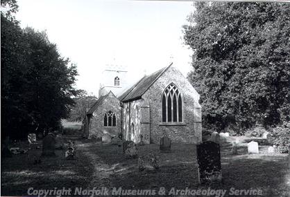
St Mary's Church, Anmer (©NCC)
The medieval parish church of St Mary's (NHER 3513) which stood at the centre of the medieval village is now isolated within the park and was heavily restored in the 19th century.
Sarah Spooner (NLA), July 2005.
Further Reading
Field book of 1600 referring to the barrows held at the Norfolk Record Office (NRO MC40/7/484x7)
Mills, A. D., 1991. Dictionary of English Place Names (Oxford, Oxford University Press)
Pevsner, N. and Wilson, B., 1997. Norfolk 1: Norwich and North East (London, Penguin)
Rye, J., 1991. A Popular Guide to Norfolk Place Names (Dereham, The Larks Press)