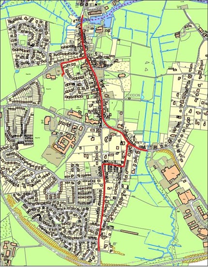
Take a walk around the market town of Loddon and discover its hidden Second World War past.
Following the evacuation of the British and Commonwealth and French forces at Dunkirk on the 4th of June 1940 only the Channel stood between Britain and Blitzkrieg. Most of the army’s weapons and equipment had been abandoned on and around the beaches of Dunkirk following Operation Dynamo.
On the 27th of May 1940 General Ironside was given the task of planning and constructing the defences that would hopefully stave off a German invasion. He settled upon a strategy that involved the use of 3 stoplines and a mobile reaction force.
The Stoplines were known as the:
Coastal Crust- defences on the coast consisting of barbed wire, mines, coastal batteries and Pillboxes.
The GHQ Line- an inland stopline stretching the length of Britain.
Secondary Stoplines- Additional stoplines and ‘Nodal Points’ constructed to complement the Coastal Crust and the GHQ line.
Loddon is a prime example of a Nodal Point. The town was given all round defence with defences placed to cover the roads into the town and defences sited to protect the important river crossing between Loddon and Chedgrave.
Start the walk to the south of Loddon at the bottom of High Bungay road next to the bypass. Facing East in the field you will see a Pillbox.
1: Type 22 Pillbox (NHER 17497)
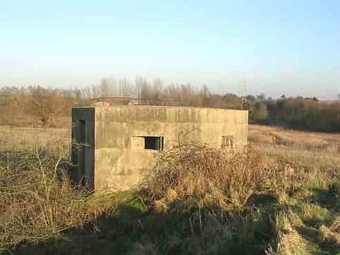
The most visible remainder of these defences is the Pillbox, such as the one that can be seen from here. A Pillbox is a small concrete structure which would have enabled troops to fire their weapons while providing protection from incoming fire.
This Type 22 Pillbox was constructed to defend the southern roads into Loddon. The Pillbox represents only a fraction of what would have been present during WW2. It is more than likely that there would have been trenches and barbed wire around this Pillbox.
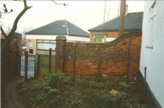
Walk up High Bungay road to the Cadet hall.
2: Home Guard Stores (NHER 35982)
From the road you can see a small building in the garden to the rear of the cadet hall. This is one of two Home Guard Stores. They were originally built as stores for the ammunition and explosives of the Home Guard.
As Loddon was a category ‘B’ Nodal Point, the Home Guard would have been responsible for its defence and were expected to hold out for as long as possible to delay the enemies advance. You’ll all have heard of the Home Guard, more than likely through ‘Dads Army’. The Home Guard originally started out as the Local Defence Volunteers (LDV) on the 14th May 1940. Their task was to protect their homes and villages from German parachutists and also man local defences. Initially they lacked any weapons, mainly because all the new armaments went to the armed forces as they lacked weapons after Dunkirk, eventually they were renamed the Home Guard and grew into an effective fighting force.
Move up High Bungay Road and cut across Davy Place to Low Bungay road on to Beccles Road until you get to the bridge.
3: Site of a WW2 Pillbox (NHER 32725)
Beccles Road was the road that led into the village from the east. This road was defended by a second Pillbox which has since been demolished. Of the 28,000 pillboxes built, only around 6,000 survive.
This Pillbox was sited to defend the road leading into the village. This bend in the road would have meant that the pillbox wasn’t visible until the last possible moment. The river here would have also acted as an anti-tank ditch.
Walk along Beccles road onto High street and into to the centre of Loddon.
The narrow streets of Loddon would have provided the defenders with a major advantage. Tanks are not suited to urban environments such as this as they are not given the freedom of movement they need to operate and are extremely vulnerable. Houses and narrow streets would have provided the defenders with many hiding places for ambushes and snipers.
4: Holy Trinity Church (NHER 10538)
The ringing of the church bells would have indicated that the invasion had begun. This would have given members of the local Home Guard time to prepare their defences and for the arrival of German troops. The bell tower would have also acted as a look out post to view the local area of enemy troop movements.
Walk further along High street to the junction with George Lane.
5: Roadblock (NHER 57845)
In the garden to the left there is a very rare survival. The upright sections of railway track are an example of a roadblock that would have blocked this junction in the village centre and would have stopped the movement of vehicles along George Lane and Bridge Street. It is likely that the original roadblock would have stretched along both of the roads. The remaining rails have been placed to stop tanks demolishing he wall and going around the roadblock. Roadblocks were intended to be set up quickly so as not to hinder movement of friendly troops. This roadblock would have consisted of a number of concrete sockets sunk into the surface of the road. Into these sockets would be placed bent steel girders and railway track like these.
Walk along George Lane and onto Old Market Green.
6: Spigot Mortar Thimble (NHER 40451)
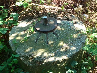
This is the remaining thimble of the 29mm Blacker Bombard or Spigot Mortar. The Spigot Mortar was an Anti-Tank weapon invented by Lt. Col. Blacker, with a maximum effective range of 450 yards and an effective range of 75-200 yards. This one has been placed to fire upon the roadblock situated at the junction in the town centre. It is possible that this has been moved or is one of a pair of positions in this area.
Walk back along George Lane and up Bridge Street to the bridge over the river Chet.
7: Type 22 Pillbox (NHER 17498)
This bridge is the focus of the defences of Loddon. This Type 22 Pillbox has been placed to defend the bridge and would have been the last line of defence in Loddon. This bridge is the last major chokepoint on the road to Norwich and the Home Guard would have been expected to hold out here as long as possible. This would have given the defenders of Norwich much needed time to prepare for the approaching invasion forces and also provided them with a warning before the Germans arrived.
The defences of Loddon provide us with a classic example of a Nodal point. The strategy behind the defences is also clearly defined. The roads leading into the town were defended by a Pillbox. This would have slowed the enemy troops on the outskirts of the town, allowing the defenders some time to set up their defences in the centre of the town. This defence in depth strategy would have slowed down the enemy advance further. The presence of drainage ditches and marshy ground around Loddon would have inhibited the use of Tanks.
You can also see how the landscape of Loddon and its urban nature would have been used to the defenders advantage. The presence of drainage ditches and marshy ground around Loddon would have inhibited the use of Tanks and forced them to enter the town centre using the roads. The streets would have hemmed them in and the roadblock would have stopped their advance, opening them up to attack making the advance on the bridge very costly.
In the event of an invasion the local Home Guard would have fought to the death.
By Chris Kolonko