This Parish Summary is an overview of the large amount of information held for the parish, and only selected examples of sites and finds in each period are given. It has been beyond the scope of the project to carry out detailed research into the historical background, documents, maps or other sources, but we hope that the Parish Summaries will encourage users to refer to the detailed records, and to consult the bibliographical sources referred to below. Feedback and any corrections are welcomed by email to heritage@norfolk.gov.uk
Fulmodeston is a relatively large parish in the north of the county, just east of Fakenham. It was formed by the amalgamation of several smaller parishes; Clipstone, Croxton, Fulmodestone and Barney. There is still modern settlement in each of these earlier parishes although only Clipstone Farm remains at Clipstone. Each of the villages is mentioned in the Domesday Book. Clipstone, Croxton and Fulmodestone were owned by William of Warenne, whilst Barney has an entry under the holdings of Peter of Valognes. Croxton was held as part of the manor of Fulmodestone although it had its own separate church. A church is also recorded in Fulmodestone but none is recorded in Clipstone or Barney. Interestingly Barney is held as part of Gunthorpe, a parish to the north of Fulmodestone, but in more modern times has been amalgamated with the southern parish of Fulmodeston. These extensive entries demonstrate that the settlements within the modern parish of Fulmodeston were settled by the medieval period. Their names can also be used as evidence of their antiquity. Clipstone means 'farmstead of Klyppr'. 'Klyppr' is a Scandinavian name and suggests the village may have been founded in the Late Saxon period. Croxton means 'farmstead in a nook' or 'farmstead of Krokr'. Again 'Krokr' is a Scandinavian name. Fulmodeston is an unusual name and can be translated either as 'farmstead of Fulcmod' (an old German name) or 'farmstead of Fulcmond' (an Old English name). Finally Barney could be translated in several ways. It may mean 'island or dry ground in a marsh belonging to Bera' or 'island of barley' or 'island with a barn'. To summarise the documentary evidence we can see that settlement in the modern villages dates back at least as far as the Saxon period. To understand activity in the parish earlier than this date we have to look to the archaeological records.
The earliest dated find from the parish is a Palaeolithic handaxe (NHER 25652). Other flint tools recovered date from the Neolithic period. These include axeheads (NHER 2163, 2164 and 39366) and a barbed and tanged flint arrowhead (NHER 25654). An interesting Neolithic site can also be seen on aerial photographs. Cropmarks of two square barrows, a rectangular enclosure and a possible Neolithic cursus (NHER 32226) can be seen. The cursus, a series of long parallel ditches and banks, may have been a processional route or a defensive earthwork. Evidence for the later prehistoric period can also be found. A Bronze Age gold cup ended bracelet (NHER 2165) was found on Fulmodeston Heath in the 18th century and a Bronze Age copper alloy axehead (NHER 2166) has also been recovered. Several more enigmatic prehistoric sites have also been recorded. Concentrations of burnt flints and darkened soil have been identified at several sites (NHER 13729, 13730 and 28563). These may be the remains of burnt mounds. It is not clear what these monuments were used for, but they may have been large hearths where stones were heated and then placed in pottery containers to heat water or food. Because of the absence of pottery or worked flints at these hearths it is often difficult to provide a more accurate date than 'prehistoric' for them.
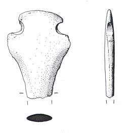
A Middle Bronze Age rapier butt from Fulmodeston. (© NCC.)
There is also evidence for activity in Fulmodeston in the Roman period. Most of this evidence is gathered from scattered finds found during fieldwalking and metal detecting. One concentration of Roman pottery was suggested as the site of a Roman building (NHER
13094) but this is not altogether clear. The square barrows (NHER
32226) seen at the cropmark site discussed above may also be Roman. In addition to these possible sites Roman pottery (NHER
13107,
17342 and
19188) and Roman coins (NHER
17342 and
32188) have been found at various locations. The use of Roman building material in St Mary's Church, Barney (NHER
2181) also suggests the presence of a fairly substantial Roman building nearby. A possible Roman iron spearhead (NHER
23159), a miniature Roman vessel (NHER
25990) and part of a Roman silver bracelet (NHER
28845) are also evidence of activity. The miniature vessel may well have had a votive or ritual use.
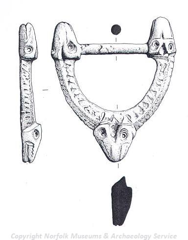
A Middle Saxon buckle dating from the 9th century. (© NCC.)
Finds made by metal detectorists are the only evidence we have for activity in the parish in the Early Saxon period. An Early Saxon small long brooch fragment (NHER
32188) and an Early Saxon pendant, brooch and mount (NHER
17342) from another location are the only archaeological records for this period. In addition to these finds the iron spearhead (NHER
23159) described above may also be Early Saxon. Unfortunately evidence for Middle Saxon Fulmodeston is similarly scarce and only fragments of pottery (NHER
1069) remain to hint at the presence of occupation in the area. None of these finds, from the Early Saxon or Middle Saxon periods, are clear evidence for the location of activity or settlement.
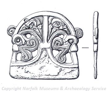
An Early Saxon pendant from Fulmodestone. (© NCC.)
The earliest structures to survive may date from the Late Saxon period. The nave of St Mary's Church, Barney (NHER
2181) is of Saxo-Norman date. A scatter of Late Saxon pottery may mark the position of a Late Saxon building (NHER
13094). Fragments of Late Saxon pot (NHER
12879 and
13107) have also been recovered in different locations. Several glamorous metal detecting finds have also been made including a lovely example of a 9th century buckle decorated with animals' heads and a 10th century Viking horse and rider brooch (NHER
17342) found at the same location. This brooch makes an interesting link with the possible Scandinavian elements in the local place names.
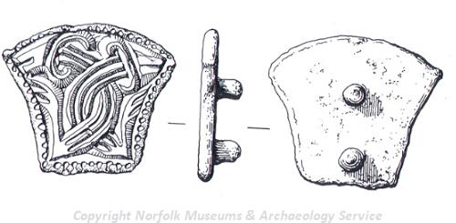
An Early Saxon mount from Fulmodestone. (© NCC.)
We know from the documentary evidence that there was settlement in the modern villages by the medieval period. We also know from the Domesday Book that there was a village at Clipstone (NHER 2171) that was recorded as amalgamating with Kettlestone parish in 1334. Unfortunately the exact location of this settlement has not been identified. Documentary sources also record the foundation of a medieval hospital at Croxton (NHER 14542) in 1250 but it isn't clear whether this is Croxton in north Norfolk or near Thetford. It has been suggested that the location of Fulmodeston has moved slightly since the early part of the medieval period, only mirroring modern settlement since the 14th century. Old Fulmodeston (NHER 2173) has been identified by a scatter of 11th to 13th century pottery fragments recovered during fieldwalking. Many of the churches in the parish date to this period. The chapel of St John the Baptist, Croxton (NHER 1083) is on the site of a Domesday church but the earliest parts of the present structure date to the 11th or 12th centuries. Although St Mary's, Barney (NHER 2181) has a Saxo-Norman nave most of the rest of the structure was built in the 13th century. St Mary's, Fulmodeston (NHER 1084) is also on the site of a church recorded in the Domesday Book but the ruined structure there now is medieval. The tower was added in 1450 and is the most imposing part of the church remaining. In addition to these religious structures several medieval moated sites (NHER 1068, 2180, 7152, 12158, 12159 and 28091) can be seen on aerial photographs. This plethora of moats is because most of the parish is on moisture-retaining Boulder Clay which makes keeping the moats wet easier. These moats normally surrounded buildings and a number of masonry remains have been recorded in the Fulmodeston examples. Several intriguing medieval finds have also been made in the parish. During the demolition of a cottage a 14th or 15th century terracotta head (NHER 2169), perhaps that of John the Baptist, from an arch was uncovered. Metal detectorists have also made some interesting finds including that of a Portuguese medieval coin (NHER 31718) and a 15th century scallop shaped gilt copper alloy harness mount. A medieval bone candle holder (NHER 25990) has also been recovered.
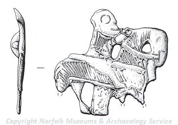
A Viking horse and rider brooch from Fulmodestone. (© NCC.)
An interesting post medieval site was found by chance during the digging of a septic tank. The post medieval pottery works (NHER
1105) were discovered when many fragments of pottery and kiln wasters were excavated. The site of the actual kilns was not found but cannot be far away. Many post medieval buildings remain, the oldest recorded in the database being Croxton Farm (NHER
30280) which was built in 1600. Another interesting building is Philippo's Farm which is a 17th century house with a 19th century brick facade. The most unusual part of the farm is, however, a nearby barn of a similar date, which is inscribed with a memoriam to the internment of the estate owner for 14 days for eating his own game out of season. Clipstone Farm (NHER
34737) is an excellent example of a Holkham Estate Farm that was not altered in the 19th century. The farm is laid out in an E shape and includes barns, stables and a granary. The clay underlying the soil in the parish is suitable for brick making and many post medieval brick kilns (NHER
15223,
15224,
15291 and
17623) have been identified in the parish, some from old maps and others from extant buildings. A post medieval pound (NHER
15203) is also recorded on old maps. Croxton windmill (NHER
12519) was the site of an early post mill which was later replaced by the tower mill in 1886. Christ Church in Fulmodeston (NHER
2183) was built at a similar time in 1882.
The most modern archaeological site recorded on the database is a World War Two bombing decoy (NHER 13605). Dummy Blenheim bombers and flare paths were used to trick enemy planes and to provide protection for nearby RAF West Raynham.
Megan Dennis (NLA), 16 December 2005.
Further Reading
Ashwin, T. and Davison, A. (eds.), 2005. An Historical Atlas of Norfolk (Chichester, Phillimore)
Brown, P. (ed.), 1984. Domesday Book, 33 Norfolk, Part I (Chichester, Phillimore)
Mills, A.D., 1998. Dictionary of English Place Names (Oxford, Oxford University Press)
Rye, J., 2000. A Popular Guide to Norfolk Place-names (Dereham, The Larks Press)