This Parish Summary is an overview of the large amount of information held for the parish, and only selected examples of sites and finds in each period are given. It has been beyond the scope of the project to carry out detailed research into the historical background, documents, maps or other sources, but we hope that the Parish Summaries will encourage users to refer to the detailed records, and to consult the bibliographical sources referred to below. Feedback and any corrections are welcomed by email to heritage@norfolk.gov.uk
Flitcham with Appleton is a large parish in the northwest of the county. The Peddar's Way (NHER 1289) forms the eastern parish boundary, and the River Babingley the southern boundary. The small village of Flitcham is in the south of the parish, whilst the village of Appleton has dwindled to a few houses.
The earliest archaeological evidence from the parish is a flint blade (NHER 30266) which may date to the Mesolithic period. Neolithic axeheads (NHER 3264, 3492, 3539 and 16810), Neolithic arrowheads (NHER 3539) and other prehistoric flint implements (NHER 3478 and 3539) have also been found. A prehistoric hearth (NHER 16812) was discovered in 1902, and, more recently, a possible prehistoric burnt mound (NHER 31735) was ploughed up. A number of ring ditches (NHER 3478, 3479, 3480, 17437, 35564, 35563, 17438, 17440 and 40510), probably dating to the Bronze Age, are visible as cropmarks or soilmarks on aerial photographs. Two Bronze Age barrows have survived as earthworks; a bowl barrow (NHER 3540) stands on Anmer Minque, and Bronze Age pottery has been found on the site, and the other is a round barrow known as Flitcham Burgh (NHER 3477), which was used as the moot hill of Freebridge Hundred during the medieval period. Iron Age coins (NHER 24819 and 29370) and pottery (NHER 3481, 3488, 3501, 31102 and 31425) have been found scattered throughout the parish, as well as a possible shield fitting (NHER 29853).

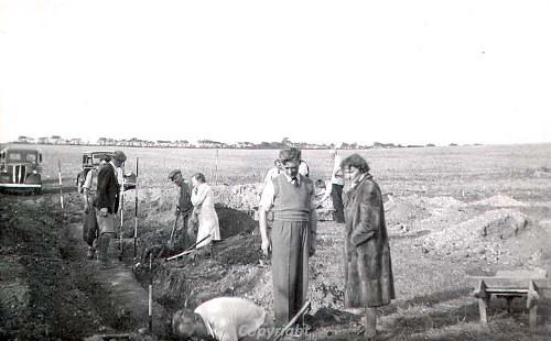
The excavation of Denbeck Wood Roman villa in 1948.
During the Roman period a fairly consistent settlement pattern was established in northwest Norfolk, of substantial buildings, or villa', on slopes overlooking smaller settlements in the valleys. The site of a Roman villa (NHER
3481) has been excavated in Denbeck Wood, near Appleton. The excavations took place in the late 1940s, and revealed the main house, which had glazed windows and a tessellated floor, and a courtyard surrounded by small buildings, as well as a possible bath house, which had pink painted wall plaster. The Roman coins, pottery, brooches and other metalwork found on the site date mainly from the 3rd to the early 4th centuries. Another substantial Roman building (NHER
3486) has been found in the parish, and pottery, flue tiles and other architectural fragments have been found on the site. These two buildings are part of a group of villas in the area, including Congham and Gayton, which lie on the junction of chalk and clay soils, and at the source of water courses. The villa's appear to have been the centre of small estates, and no other Roman settlement sites are known from the immediate area, although the floor of another possible Roman building (NHER
3488) has been found in the parish, close to the River Babingley. Roman coins (NHER
3482,
3485,
3487,
13691,
15702,
18040,
23300,
24819,
29853 and
33752), fragments of pottery (NHER
3255,
3483,
3489,
3541,
20238,
23301,
29227,
29853,
31102,
31425 and
33752) have been found scattered throughout the parish, as well as part of a Roman pin (NHER
29266), and a fragment of a Roman bracelet (NHER
39948).
Early Saxon pottery, brooches and other metalwork have been found on the site of the Roman villa (NHER 3481), as well as Middle Saxon pottery and coins, and Late Saxon pottery and metalwork. An Early Saxon brooch (NHER 29266), a Middle Saxon furniture fitting (NHER 29226), and a Late Saxon dress fitting (NHER 31425) have also been found in the parish, as well as pottery spanning the whole Saxon period (NHER 29227). Flitcham comes from the Old English meaning 'a homestead or village where flitches of bacon are produced', and the settlement is recorded in the Domesday Book as relatively large and valuable, with a number of sheep, a mill and a church; St Mary's Church (NHER 3484) in Flitcham dates back to the late 11th century. Appleton comes from the Old English meaning 'farm where apples grow', and is also mentioned in Domesday Book as a large and valuable settlement, also with a large number of sheep, and a church. St Mary's Church (NHER 1042) in Appleton, which is now in ruins, has a round tower which dates back to the Late Saxon period.

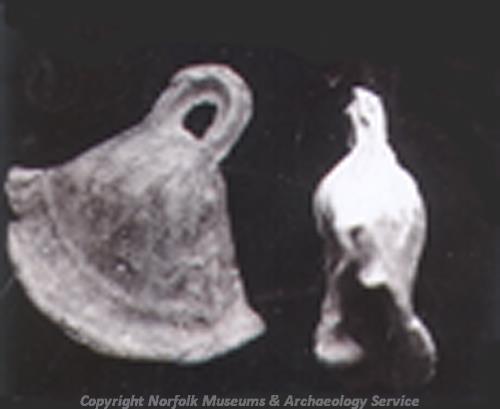
A post medieval lead toy bell from Flitcham. (© NCC.)
During the medieval period the parish was more densely settled than it is today. The village of Appleton (NHER 1042), which was fairly substantial in the Late Saxon period, was gradually deserted over the course of the medieval period. An early 17th century estate map, based on a late 16th century survey, depicts just St Mary's Church (NHER 1042), a double moated manor house and a large farm. St Mary's is now in ruins, and the moated house and farm survive as earthworks. The village of Little Appleton (NHER 3501) stood to the south of the larger village of Appleton, but by the early 17th century, the village had shrunk to a single farm, shown on the estate map of 1617. The earthworks of medieval house platforms, hollow ways and ridge and furrow are visible on aerial photographs around the site of the settlement. In the 14th century a chantry chapel dedicated to St Katherine was founded close to the church (NHER 1042). The manor of Appleton was acquired by the Paston family in the 16th century, and Sir Edward Paston built a large mansion in the village in the late 1590s, known as Appleton Hall (NHER 3499). The Hall was destroyed by fire in 1707, but a drawing made before the fire shows an elaborate house with a porch tower. The deserted medieval settlement of Gatton (NHER 3488 and 3502) was in the south of the parish, and is mentioned in medieval documents from the 13th to the 16th centuries. Linear earthwork banks and ditches are visible on the ground, and in aerial photographs, on the site of the settlement. Another area of medieval settlement in the parish was the deserted settlement of Denton (NHER 3489), which lay close to the village of Appleton. A late 16th century map of Denton depicts Newgate House, the site of which is now visible as a low earthwork mound. In 1987 the remains of a timber bridge (NHER 3489), possibly dating to the medieval period, were found in Den Beck on the site of the settlement. Denton had completely disappeared by the time of the late 16th century survey, and only the medieval moated site (NHER 39250) known as 'Lynes Moat' is shown on the 1617 estate map.
Flitcham itself is a small, linear village in the south. St Mary's Church (NHER 3484) has late 11th and 12th century windows and blind arcading. The church was extended in the 15th century, although the chancel has been demolished and is now visible as an earthwork platform. The church was restored in the 19th century. In 1217 an Augustinian Priory (NHER 3492), also called St Mary's, was founded in Flitcham as a dependent cell of the Priory at Walsingham. The Priory was dissolved in 1538, and the buried remains of the Priory church and cloisters, and various earthworks, including those of the Priory's water management system, surround the 19th century farmhouse that now stands on the site.
Appleton Water Tower (NHER 15701) is an elaborate 19th century water tower, built to serve the nearby Sandringham Estate. The tower has an external stair turret, which leads to a viewing room used by the Royal Family. The water tower has been restored by the Landmark Trust. Appleton House (NHER 3499) was built in the 1860s for the King of Norway. During World War Two a large air raid shelter was built in the house, for the use of the Norwegian Royal Family and King George VI. A pillbox (NHER 32382) and an anti aircraft battery (NHER 3480) were also built during World War Two.
Sarah Spooner (NLA), 9 December 2005.
Further Reading
Brown, P. (ed.), 1984. Domesday Book: Norfolk (Chichester, Phillimore)
Mills, A.D., 1998. Dictionary of English Place-Names (Oxford, Oxford University Press)
Norfolk Record Office BRA 2524/6, Map of the Manor of Appleton (part), 1617, based on a survey of 1596.
Rye, J., 1991. A Popular Guide to Norfolk Place-names (Dereham, Larks Press)