This Parish Summary is an overview of the large amount of information held for the parish, and only selected examples of sites and finds in each period are given. It has been beyond the scope of the project to carry out detailed research into the historical background, documents, maps or other sources, but we hope that the Parish Summaries will encourage users to refer to the detailed records, and to consult the bibliographical sources referred to below. Feedback and any corrections are welcomed by email to heritage@norfolk.gov.uk
Nordelph is a large parish in the Fens close to the town of Downham Market. The small village of Nordelph is in the north, and the rest of the landscape of the parish is dominated by large arable fields and drains.
The earliest archaeological find from the parish is a Neolithic flint scraper (NHER 2496). The only other prehistoric evidence from Nordelph is the cropmarks of Bronze Age ring ditches (NHER 15808, 36372) that have been recorded from aerial photographs.
There is more evidence from the Roman period. The Fen Causeway Roman road (NHER 2796) runs through the parish and the Fenland Survey has revealed a number of Roman sites, including domestic settlements (NHER 4239, 13403, 24215, 24479, 25000, 25060) and settlements that were associated with salterns (NHER 16600, 24216, 25003, 25059, 25062, 25063). Other Roman salt works have also been identified in the parish (NHER 2495, 4235). Fieldwalking as part of the Fenland Survey recovered fragments of Roman pottery (NHER 4238) from near Woodhouse Farm. The survey also revealed evidence for a Roman canal that ran alongside the Fen Causeway Roman road. The possible canal runs east to west across this site (NHER 4238). The cropmarks of several Roman peat cuttings (NHER 4220, 4235, 11835, 21182, 32064, 36372) have been identified from aerial photographs. Fragments of Roman pottery (NHER 2482, 2486, 25001, 25061), a mortarium (NHER 4234), a coin (NHER 4237) and a coin hoard from Upwell Fen (NHER 2497) have also been found.
Although Nordelph was settled during the medieval period, there is little archaeological evidence of the period. Medieval peat cuttings (NHER 19179) have been recorded as cropmarks on aerial photographs. The Well Creek (NHER 14418) is a pre 13th century canal, followed by the New Podyke, which was built in 1422.
The drainage of the Fens has been key to the development of the parish. Popham’s Eau (NHER 4223) was dug in the early 17th century in an attempt to try and connect the Well Creek to the River Nene to improve drainage. Tong’s Drain (NHER 23225) is an artificial watercourse built by Vermuyden in 1653 from Salter's Lode to Stowbridge to relieve pressure on the River Great Ouse. The London Lode (NHER 29549) was constructed by the London Merchants in the 17th century. The drain follows the course of Silt Road and once continued into the village of Nordelph to join Popham's Eau, although this section has now been infilled. The sites of several post medieval drainage pumps are shown on Faden’s map of Norfolk, published in 1797 (NHER 4226, 14508, 14509, 14510, 14514), and the sites of other drainage pumps (NHER 4246, 16326) have been recorded from other historic maps.

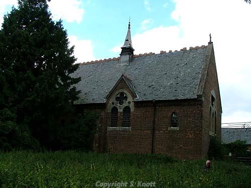
Holy Trinity Church, Nordelph, a Victorian red brick church built in 1865. Photograph from www.norfolkchurches.co.uk
(© S. Knott.)
The Victoria Chapel (NHER
4248) is a former Wesleyan Methodist chapel with a pedimented façade and corner pilasters. The pediment contains a clock and the inscription 'VICTORIA CHAPEL 1861 formerly WESLEYAN CHAPEL 1861'. The chapel has been converted into a house. Holy Trinity Church (NHER
4247) is a Victorian red brick church, built in 1865 in the Early English style with lancet windows and plate tracery. Mill House (NHER
19219) is a post medieval smock mill that has now been converted into a house.
The most recent archaeology in the parish dates from World War Two. A number of pillboxes (NHER 32354, 32360, 32363, 32367, 32369, 32370), gun emplacements (NHER 32356, 32365, 32366) and Home Guard shelters (NHER 32364, 32368) have been recorded.
Sarah Spooner (NLA), 4 September 2006.
Further Reading
Brown, P. (ed.), 1984. Domesday Book: Norfolk (Chichester, Phillimore)
Mills, A. D., 1998. Dictionary of English Place-Names (Oxford, Oxford University Press)
Rye, J., 1991. A Popular Guide to Norfolk Place-names (Dereham, Larks Press)