This Parish Summary is an overview of the large amount of information held for the parish, and only selected examples of sites and finds in each period are given. It has been beyond the scope of the project to carry out detailed research into the historical background, documents, maps or other sources, but we hope that the Parish Summaries will encourage users to refer to the detailed records, and to consult the bibliographical sources referred to below. Feedback and any corrections are welcomed by email to heritage@norfolk.gov.uk
North Pickenham is a small parish within Breckland, close to the town of Swaffham. The small village of North Pickenham is in the north of the parish, and to the south is the site of the village of Houghton-on-the-Hill, which has now dwindled to a farm and the parish church. Pickenham comes from the Old English meaning ‘homestead or village of a man named Pica’, and Houghton means ‘ farmstead on or near a ridge or hill-spur’.

A Bronze Age round barrow that was also used as the meeting place for Greenhoe Hundred until the 17th century.
The earliest archaeological evidence from the parish dates from the prehistoric period, and prehistoric pot boilers (NHER
20161) and Neolithic flints (NHER
4620) including a scraper (NHER
14012) and a knife (NHER
25655) have been found. Until the mid 20th century there were three Bronze Age round barrows (NHER
4623) in Hilly Plantation. The barrows were the meeting place of Greenhoe Hundred during the medieval period and into the early post medieval period. The condition of the barrows gradually deteriorated and the last was destroyed in the 1950s. A Bronze Age spearhead (NHER
19449) has been found during metal detecting.
Several concentrations of Iron Age pottery (NHER 41360, 41362, 41363) have been found in the area around St Mary’s Church in Houghton-on-the-Hill, suggesting that this was an area of Iron Age settlement. An Iron Age silver coin (NHER 28874) and an Iron Age or Roman sword guard (NHER 32316) have been found during metal detecting.

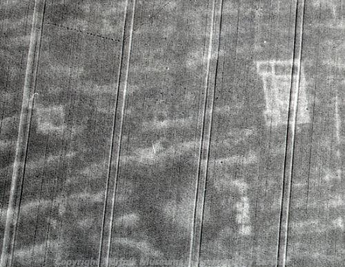
The spectacular cropmarks of a Roman villa in North Pickenham. (© NCC)
A Roman road (NHER
3697) forks off from the Peddar’s Way (NHER
1289) and runs through the parish to the Roman settlement at Toftrees (NHER
7112). The course of the road can be traced along parish boundaries, field boundaries and roads. The spectacular cropmarks of a Roman villa (NHER
29034) are visible on aerial photographs. The villa is an excellent example of a late Roman twin-wing villa with a large central room and two large living rooms to either side. The cropmarks of the villa are so clear that the details of the hypocaust, the underfloor heating system, are visible. Close to the villa are the cropmarks of another small building, possibly a Roman temple, as well as three possible cist tombs. Roman finds from the parish include coins (NHER
4624,
17426,
19449,
32088), brooches (NHER
4624,
19449), an armlet (NHER
32316) and fragments of pottery (NHER
41360).
Metal detecting has recovered a number of lovely Early Saxon artefacts, including brooches (NHER 4624, 19449, 28852), wrist clasps (NHER 19449, 32317), a gold casket mount (NHER 19449) and a personal ornament with carved decoration (NHER 20857). A Middle Saxon strap fitting (NHER 28852) and a Middle or Late Saxon strap-end (NHER 24012) have also been found. In the Domesday Book no distinction is made between North and South Pickenham, which were listed as relatively large holdings with mills, fisheries and livestock. Houghton-on-the-Hill is also mentioned in Domesday Book, with a solitary freemen held by a man named Herlwin.
St Andrew’s Church (NHER 4644) dates back to the medieval period but was largely rebuilt in 1863. Documentary evidence shows that a medieval cross once stood in the churchyard, possibly the same cross (NHER 32269) that was later found in a wall in the village. Several pieces of Late Saxon carved stonework have been incorporated into the wall of the churchyard. During the medieval period a chapel dedicated to St Paul (NHER 4639) was close to St Andrew’s Church. The site of the medieval manor of Virley’s (NHER 13128) was situated to the south of the village. A medieval moat is shown on the site on the Tithe Map of 1839. Several ditched enclosures (NHER 31639) to the east of Lower Farm probably date to the medieval period.

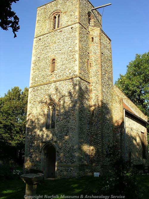
St Mary's Church, Houghton-on-the-Hill. (© NCC)
St Mary’s Church (NHER
4625) in Houghton-on-the-Hill has become famous after a remarkable series of 11th century wall paintings were discovered during restoration work in 1996. The wall paintings are an unparalleled survival of their kind in Britain, and have been preserved inside the church. The church itself dates back to the 11th century and contains much reused material. The nave has a pair of opposing double-splayed windows and some original render on the exterior. The church was abandoned in the 1930s and fell into neglect, but has been recently rediscovered and restored. In 2000 an excavation carried out by the NAU revealed the foundations of the church and the original chancel, and a second excavation in 2001 revealed a number of burials around the church. The medieval village of Houghton-on-the-Hill (NHER
4630) surrounded the church, and the earthworks of a medieval hollow-way and enclosures have survived on the site, which was gradually deserted throughout the medieval period. The Blue Lion public house (NHER
45350) is a late 17th century brick building with an 18th century rear wing and other later alterations.

The Cold War antenna at North Pickenham. (© NCC)
North Pickenham airfield (NHER
2697) opened as a USAAF base in 1944 and the last group of B-24 Liberators to be based in Norfolk were operational here until the airfield closed in 1945. There is now a small commemorative stone on the airfield to the memory of those who served here during World War Two. A British aircraft, a Bristol Blenheim (NHER
14451), crashed to the south of the airfield site early in 1942. The imposing antenna array (NHER
36534) on North Pickenham Road was constructed in the 1950s at the height of the Cold War. The antenna has been identified by English Heritage as a monument of national importance.
Sarah Spooner (NLA), 8 August 2006.
Further Reading
Brown, P. (ed.), 1984. Domesday Book: Norfolk (Chichester, Phillimore)
Mills, A. D., 1998. Dictionary of English Place-Names (Oxford, Oxford University Press)
Rye, J., 1991. A Popular Guide to Norfolk Place-names (Dereham, Larks Press)