This Parish Summary is an overview of the large amount of information held for the parish, and only selected examples of sites and finds in each period are given. It has been beyond the scope of the project to carry out detailed research into the historical background, documents, maps or other sources, but we hope that the Parish Summaries will encourage users to refer to the detailed records, and to consult the bibliographical sources referred to below. Feedback and any corrections are welcomed by email to heritage@norfolk.gov.uk
Needham is a small parish in the South Norfolk district. It is south of Starston on the Norfolk-Suffolk border. The southern parish boundary runs along the River Waveney. The village name comes from Old English and can be translated as ‘poor or needy homestead’. There are only fifty-seven archaeological records for the parish. Fieldwalking in advance of the construction of the Brockdish to Needham bypass has, however, uncovered a significant amount of material including the Needham hoard of Roman silver denarii (NHER 29621) now in the Norwich Castle Museum. Together with other finds reported by the public we can use this information to put together a picture of how the landscape was used in the past. It should be remember that this picture may change with new discoveries.

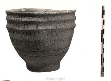
A complete Neolithic vessel from Needham.
The earliest recorded finds date to the Mesolithic period. A group of flints found in a gravel pit include Mesolithic microliths (NHER
11071). A metal detectorist recovered a Mesolithic to Early Neolithic flint axehead (NHER
35422). Neolithic worked flints (NHER
11072) including two axeheads (NHER
11073 and
14831) have also been recovered. Excavations in a gravel pit in the first half of the 20th century recovered a complete Neolithic vessel containing a cremation (NHER
11071). Pieces of Bronze Age pot have been recovered from the same site (NHER
11071). Prehistoric worked flints (NHER
16631 and
16632) were a common find during the fieldwalking survey in advance of the construction of the bypass. Although these have not been clearly dated within the prehistoric period they are evidence of activity in the area at this time.
An Iron Age coin and pieces of Iron Age pot (NHER 24601) have been found on the site of a later Roman settlement suggesting activity may have begun here in the Iron Age. Iron Age coins were also found on the site of the Roman coin hoard (NHER 29621) although it is not clear if they were originally part of the hoard itself.

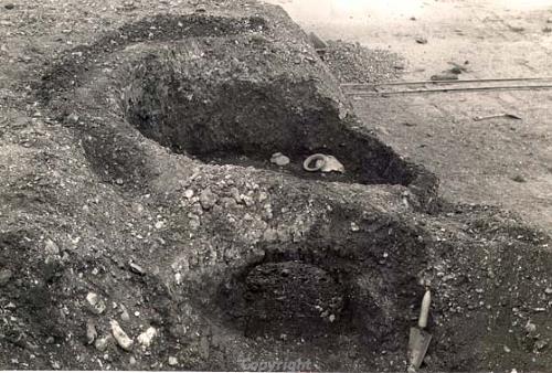
The excavation of a Roman pottery kiln at Needham.
Evidence of a Roman settlement and pottery kilns (NHER
11071) has been uncovered in a gravel pit. The site was first identified in 1921 and excavated in the 1930s. These excavations revealed the presence of three Roman pottery kilns, a hearth and several ditches. These features and accompanying Roman finds have been interpreted as a small Roman settlement. A second area of activity was originally identified from a large scatter of Roman objects found during metal detecting and fieldwalking (NHER
24601). These included coins, brooches and pottery. Iron Age, medieval and post medieval objects have also been recorded. Excavations at the site revealed ditches and structural features that represent Roman occupation. It is possible that these two areas situated just above the River Waveney were both part of the same dispersed settlement located in a similar position to the modern village.
Interesting Roman objects including coins (NHER 11080, 16630 and 33200) and a Dolphin type brooch (NHER 31318) have been found. Roman pot (NHER 29617) was recovered during fieldwalking in advance of the bypass and part of the Needham Roman coin hoard (NHER 29621) was also discovered this way. Later metal detecting recovered more of the hoard. It contained at least twenty-nine silver denarii dated to 109 BC to AD 64.
There is little evidence for Saxon Needham. Part of an Early Saxon small-long brooch (NHER 17787) was found after topsoil had been removed before construction of the bypass. Metal detecting recovered an Early Saxon cruciform brooch (NHER 34675). These two finds are the only signs of activity. The village is not mentioned in the Domesday Book. This suggests it may have been settled later than 1066. The absence of an entry for land in the parish is relatively unusual. The earliest documented mention is in 1352. It is possible that the village was too small prior to this date to be mentioned, or was included (unnamed) in the listing of an adjacent parish.
St Peter’s Church (NHER 11095) has a Late Saxon or Norman round tower. The top of the church tower was extended with Tudor brick. Most of the rest of the building dates to the post medieval period. Inside the late 15th century bench ends include one with the inscription 'Use wel thy tyme for deth is comyng M. The sentence of God Allmighty is everlastyng E'. The only other medieval buildings to survive are two 16th century timber framed houses (NHER 45323 and 45315). A possible medieval lamprey trap (NHER 11075) was dredged out of the river. This large pottery vessel was full of holes, presumably allowing the lamprey to enter but not get back out.
Pieces of medieval pot were found on many sites along the route of the bypass (NHER 29614) and a complete 14th century green glazed jug (NHER 11074) was found in 1951. Pieces of late medieval to early post medieval pot and a possible medieval decorated copper alloy spur (NHER 16559) were found underneath the floorboards of Tudor House in the 1980s. Metal detecting recovered a medieval silver brooch (NHER 34675) and a medieval shield-shaped lead trace weight (NHER 35422).
Many of the buildings in the village are timber framed and date to the post medieval period (for example NHER 32914 and 37503). The red brick south porch of the church (NHER 11095) was probably built in the 16th century whilst the short red brick chancel was built in 1735. The Vicarage (NHER 45310) is an early 19th century red brick house with a black glazed pantile roof with gabled ends and modern porch. In the 19th century battlements were added to the top of the church tower (NHER 11095). The site of other structures, such as the windmill (NHER 15563) and a brick kiln (NHER 15564) are marked on old maps but have now been destroyed.
Megan Dennis (NLA), 21 July 2006.
Further Reading
Brown, P. (ed.), 1984. Domesday Book, 33 Norfolk, Part I and Part II (Chichester, Philimore)
Knott, S., 2005. ‘St Peter, Needham’. Available:
http://www.norfolkchurches.co.uk/needham/needham.htm. Accessed: 21 July 2006.
Mills, A. D., 1998. Dictionary of English Place Names (Oxford, Oxford University Press)
Neville, J, 2003. ‘Needham watermill’. Available:
http://www.norfolkmills.co.uk/Watermills/needham.html. Accessed: 21 July 2006.
Neville, J., 2003. ‘Needham notes’. Available:
http://www.norfolkmills.co.uk/Watermills/needham-notes.html. Accessed: 21 July 2006.
Rye, J., 2000. A Popular Guide to Norfolk Place-names (Dereham, The Larks Press)