This Parish Summary is an overview of the large amount of information held for the parish, and only selected examples of sites and finds in each period are given. It has been beyond the scope of the project to carry out detailed research into the historical background, documents, maps or other sources, but we hope that the Parish Summaries will encourage users to refer to the detailed records, and to consult the bibliographical sources referred to below. Feedback and any corrections are welcomed by email to heritage@norfolk.gov.uk
Mautby is large parish in the east of the county, close to the coast and to Great Yarmouth. The modern parish includes the hamlets of Mautby, Thrigby and Runham. The Norfolk National Mapping Programme has identified a number of cropmarks on aerial photographs that have shed light on the archaeology of the parish. The name Mautby comes from the Old Scandinavian meaning ‘farmstead or village of a man called Malti, or where malt is made’. Thrigby also comes from the Old Scandinavian meaning ‘farmstead or village called Thrykki’. Runham, on the other hand, is derived from the Old English meaning ‘homestead or enclosure of a man named Runa’.
The earliest archaeological evidence of human occupation in the parish is prehistoric flint implements (NHER 34669, 35147, 37425, 37426), including flint flakes (NHER 35300, 35722) and scrapers (NHER 35722, 35721) that have been collected over a number of years. The cropmark of a small oval enclosure may be the remains of a possible Neolithic long barrow (NHER 39066), and Neolithic flints (NHER 8633) and a Neolithic axehead (NHER 8632) have been found. An Early to Middle Bronze Age palstave or flanged axehead (NHER 37426) and a Middle Bronze Age palstave (NHER 37176) have been found during metal detecting. The cropmarks of a fragmentary field system (NHER 12997), possibly dating to the Bronze Age, have been mapped from aerial photographs. The alignment of the field system is similar to the cropmarks of another Bronze Age field system in the area (NHER 12996). A linear ditch of Bronze Age to Iron Age date (NHER 42086) has also been identified from aerial photographs, as well as ring ditches (NHER 27716, 42041) that probably date to the Bronze Age. One ring ditch with associated pits or graves (NHER 27391) is visible on aerial photographs and another ring ditch (NHER 27716) is located within an extensive cropmark complex of possible Iron Age to Roman or medieval date (NHER 21840). The relationship between the ring ditch and the surrounding cropmarks may indicate that the barrow was still visible as an earthwork when the surrounding enclosures were laid out.
An Iron Age silver coin (NHER 33156) and gold coins (NHER 35301, 36646) have been found by metal detectorists, as well as an Iron Age terret (NHER 40769), and a miniature terret (NHER 36646) that dates from the Iron Age or Roman period. A trackway and field system of possible Iron Age to Roman date (NHER 21840) has been mapped from aerial photographs, but the cropmarks may also date to the medieval period. A field system, trackways and enclosures of probable Roman date (NHER 13004, 18393, 42087, 42086) have been recorded as cropmarks. Roman finds from the parish include coins (NHER 15474, 23704, 33348, 33542, 34672, 34671, 34669, 35147), brooches (NHER 23704, 37426), a seal box lid with traces of decayed enamel (NHER 37475), a furniture mount (NHER 42651) and fragments of pottery (NHER 34669, 35147, 37555, 40861).
Early Saxon brooches (NHER 37426), a Middle Saxon Northumbrian coin (NHER 23704), a hooked tag (NHER 33348) and fragments of pottery (NHER 31209) have been found, as well as Late Saxon brooches (NHER 31209, 37426), strap ends (NHER 31209, 34671, 35147), stirrup mounts (NHER 33269, 34672), bridle cheek-pieces (NHER 34669, 35721, 36622, 39963) and an 11th century stirrup terminal with a stylised animal head (NHER 35299). The earthworks of Late Saxon to medieval saltern mounds (NHER 25151, 42412), and a possible medieval salterns (NHER 42411, 42410) have been recorded from aerial photographs. Salt-making was an important part of the local economy in the Late Saxon period, and a number of salthouses are recorded in the Domesday Book.
SS Peter and Paul’s Church in Mautby (NHER 8656) has a 12th century round tower and a 13th century nave and chancel. In the 13th century the church had a south aisle where Margaret Paston, one of the authors of the famous Paston letters, was buried in the 15th century. The aisle and Margaret’s tomb have since been demolished. The earthworks of a medieval toft (NHER 27687) are visible as earthworks and cropmarks on aerial photographs to the south of the church. The cropmarks of several enclosures (NHER 42089) have been recorded from aerial photographs to the north of the church. The enclosures probably relate to the medieval settlement of Mautby. The lost medieval village of Ness (NHER 11910) is mentioned in the Domesday Book, and the settlement was formerly thought to be in Winterton or Caister on Sea, but detailed documentary research suggests that it was actually in the area around Decoy Farm in Mautby. Mautby Hall (NHER 28941) is a post medieval hall on the site of a medieval manor house. Mid 14th century accounts describe some of the buildings and the gardens in the manorial complex, and in the 15th century the manor house was the home of Margaret Paston, the authoress of many of the Paston Letters. Her will describes the manor house in some detail, and it had a chapel, a Great Chamber and a Chapel Chamber. The will also describes the contents of her parlour which included green wall hangings and a curtained bedstead. The barn at Mautby Hall Farm (NHER 42890) is an early 18th century timber framed barn with a thatched roof.

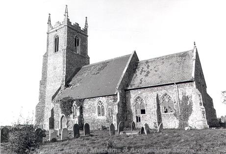
SS Peter and Paul's Church, Runham, a medieval parish church. (© NCC)
The church in Runham is also dedicated to St Peter and St Paul (NHER
8567) and has a 14th century nave and chancel and a late 15th to early 16th century west tower. The chancel was remodelled by Ewan Christian in the 19th century. The church became derelict during the 20th century until a programme of restoration began in the 1980s. Runham Hall (NHER
39577) is a late 18th century hall that was remodelled in the early 19th century. Runham Manor Farm Cottages (NHER
42891) is a mid 19th century farmhouse that is now divided into two cottages. The house has unusual 3-light windows with pointed lights and moulded mullions.
St Mary’s Church in Thrigby (NHER 8655) is an early 14th century parish church with some reused Norman stonework. The church has important 18th century wooden tracery in the windows and was restored in the 19th century. In 2003 subsidence in the churchyard revealed the entrance to a brick barrel-vaulted burial chamber. The chamber contained several late 18th and early 19th century coffins, as well as a complete skeleton that was found between the wall and one of the coffins. Thrigby Hall (NHER 17377) was built in 1735 by Thomas Ivory, who also designed the Assembly House in Norwich. The Hall was almost entirely rebuilt in the 1870s, and apart from the red brick cellars little of the 18th century house remains. In the grounds of the Hall is an early 18th century summerhouse (NHER 17378) that was also designed by Ivory. The building has round-headed arches and stuccoed pilasters. The interior has decorative plasterwork with rosettes and egg and dart mouldings. The grounds of the house are now used as wildlife gardens that are open to the public.

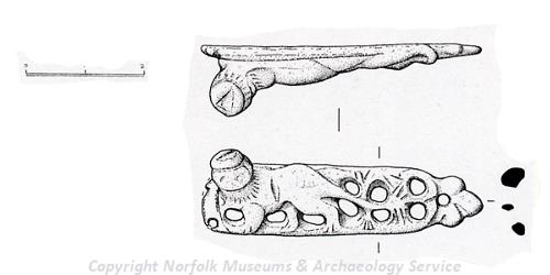
A medieval furniture mount from Mautby. (© NCC)
Other features that have been recorded from cropmarks in the parish include a possible medieval field system and trackway (NHER
18913), and the cropmarks of medieval to post medieval field boundaries or drainage ditches. The earthworks of medieval to post medieval ditches, banks and channels (NHER
42420) are visible on aerial photographs. These follow the course of the Northern Rond, a major natural marshland channel. It is of an early, probably medieval, date and formed the boundary of five parishes. Possible post medieval narrow ridge and furrow (NHER
42138,
42139,
42177) is visible as earthworks on aerial photographs. The ridge and furrow probably dates to the Napoleonic Wars when grain prices were high and areas of the marshland were taken into arable cultivation. Another area of ridge and furrow (NHER
42178) may date to the mid 19th century. The earthworks of small enclosures of probable medieval to post medieval date (NHER
42107,
42157,
42158,
42206) have been recorded on the marshes. It is possible that they were sheep cotes used to pen the animals overnight so that their manure could be collected. The manure was then transported to arable land elsewhere for use as fertiliser. Mautby Decoy (NHER
39352) is an 18th or 19th century duck decoy on the site of a possible medieval peat cutting.
Several wind pumps are marked on Faden’s map of 1797 (NHER 15574, 15628) and 19th century Ordnance Survey maps (NHER 16357). A number of wind pumps are still standing, including Runham Swim drainage mill (NHER 10409), built in the mid 19th century by W.T. England, a millwright from Great Yarmouth, and recently restored. Runham Wind Pump (NHER 10410) and Five Mile House Wind Pump (NHER 10411) are both 19th century brick drainage mills. The mills no longer have a cap and sails, but the internal machinery has survived intact. Mautby Marsh Wind Pump (NHER 14780) also dates from the mid 19th century, and has been converted into a house.
The remains of a World War Two heavy anti-aircraft battery (NHER 29751) survive near Decoy Farm, and are visible on contemporary and later aerial photographs. This site, known as YH4, was one of a group of heavy anti-aircraft (HAA) batteries positioned to protect Great Yarmouth. The gun emplacements and the command post are still standing. World War Two bomb craters (NHER 27617, 42036) are visible as earthworks and cropmarks on aerial photographs, and World War Two pillboxes (NHER 17379, 42140), and the cropmark of a World War Two hide (NHER 28935) that was used by auxiliary forces have also been recorded. A Lincoln Bomber (NHER 13680) crashed in the parish during the night of 24 September 1947, possibly after being struck by lightning during a thunderstorm. All nine of the crew were killed and they are commemorated with a plaque in SS Peter and Paul’s Church in Mautby. An excavation by the Norfolk and Suffolk Aviation Museum in 1987 recovered some parts of the aircraft, as well as personal items belonging to the crew. A Cold War Royal Observer Corps post (NHER 29027) was built in 1962 on the outskirts of Runham. The post closed in 1991.
Sarah Spooner (NLA), 19 July 2006.
Further Reading
Brown, P. (ed.), 1984. Domesday Book: Norfolk (Chichester, Phillimore)
Cornford, B., 1999. 'The Lost Domesday Vill of Ness', Norfolk Archaeology, Vol XLIII, pp 168-172
Mills, A. D., 1998. Dictionary of English Place-Names (Oxford, Oxford University Press)
Rye, J., 1991. A Popular Guide to Norfolk Place-names (Dereham, Larks Press)