This Parish Summary is an overview of the large amount of information held for the parish, and only selected examples of sites and finds in each period are given. It has been beyond the scope of the project to carry out detailed research into the historical background, documents, maps or other sources, but we hope that the Parish Summaries will encourage users to refer to the detailed records, and to consult the bibliographical sources referred to below. Feedback and any corrections are welcomed by email to heritage@norfolk.gov.uk
Martham is a large parish in the east of the county, close to the coast. The large village of Martham overlooks the flat, marshland landscape that surrounds Martham Broad. The name Martham comes from the Old English meaning ‘a homestead or enclosure frequented by martens or weasels’.
The earliest archaeological evidence from the parish is a Palaeolithic flint handaxe (NHER 8558). Fieldwalking in advance of the Bacton to Great Yarmouth gas pipeline recovered a number of prehistoric flint implements, and prehistoric flint flakes (NHER 16305) and pot boilers (NHER 19430, 19431, 20676, 32127) have been found elsewhere in the parish. Neolithic flints (NHER 8559, 41693), a saddle quern (NHER 28077) and a flint axehead (NHER 30902) have also been found, as well as a Bronze Age quartzite macehead (NHER 8528).
A probable Bronze Age barrow cemetery (NHER 29628) is visible as cropmarks on aerial photographs. The cemetery is on a spur of high land, which is a typical location for Bronze Age funerary monuments. The cropmarks of a small Bronze Age settlement (NHER 27331), with an enclosure, field boundaries and trackways have been recorded in the parish. Bronze Age pottery, Late Neolithic to Early Bronze Age flints and pot boilers have been found on the site. A number of possible Bronze Age ditches (NHER 27335) have been identified to the north of the settlement.
A field system of unknown date (NHER 11650) has been identified from aerial photographs to the south of Blood Hills Farm. The field system post-dates a possible Bronze Age round barrow (NHER 11651), and Roman, medieval and post medieval metal work have been found on the site. Another undated, but probably post Bronze Age, field system (NHER 21270) has been recorded near Top Farm.
Although no settlement sites or other archaeological features have been identified there is some evidence of activity during the Iron Age and the Roman period. Metal detecting and fieldwalking has recovered an Iron Age terret (NHER 16305) and a mount in the shape of a bull or cow’s head (NHER 24405), Roman coins (NHER 15839, 18898, 23165, 24405, 37081, 42564, 42803), fragments of pottery (NHER 15840, 23166, 28831, 34013, 41693) and a terret (NHER 24405).

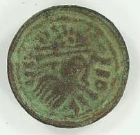
An Early Saxon nummular brooch from Martham. The brooch imitates a Roman coin. NWHCM 1983.44:A (© NCC)
Metal detecting has also recovered Early Saxon brooches (NHER
15388,
15512,
24405), a buckle and an escutcheon from a hanging bowl (NHER
24405), Early Saxon pottery (NHER
15388), Middle Saxon pottery (NHER
11798,
24405), a Middle Saxon disc brooch (NHER
15388), a Late Saxon mount (NHER
15388), an openwork box mount (NHER
21648), a disc brooch (NHER
41693) and fragments of pottery (NHER
15388,
24405). In the Domesday Book Martham was held by the King, Count Alan, the Bishop of Thetford and St Benet’s Abbey. The Bishop of Thetford’s holding was the most valuable and included a church with 50 acres of land.
St Mary’s Church (NHER 8583) dates mainly to the 14th and 15th centuries. The 15th century chancel was built by Robert Everard, the architect of Norwich Cathedral’s spire. An archaeological watching brief was carried out by the NAU in 1999 during the lowering of the floor in the west tower. This revealed the foundations of a round tower, probably dating to the 12th century, probable medieval graves, and a small lead-melting pit containing medieval window glass.

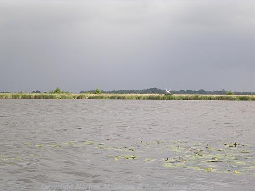
Martham Broad is a flooded medieval peat cutting. (© NCC)
Martham Broad (NHER
13508) is a medieval peat cutting that flooded in the late medieval to post medieval period. The broad was much larger in the 19th century, and had an island in the middle. A probable medieval peat cutting (NHER
27459) is visible as cropmarks and earthworks close to Ormesby Broad. The cropmarks of a medieval or early post medieval trackway (NHER
21269) has been identified on aerial photographs. Morgrove House (NHER
19716) may be built on the medieval manor of Morgrove. Similarly, Old Hall Farmhouse (NHER
19717) may also be the site of a medieval manor. The present house dates from the 18th century. Interesting medieval and post medieval finds from the parish include a 14th century octofoil pendant with the head of Christ (NHER
18521), a 15th century gold ring with the Virgin and Child (NHER
19383) and a 16th or 17th century miniature hunting horn pendant (NHER
30905)
Clarkes Farmhouse (NHER 33881) is an early 16th century timber framed house that was refronted in brick in the 18th century. The Vicarage (NHER 32860) is a 16th century brick house with a thatched roof. Brooklyn House (NHER 42884), Cess Farmhouse (NHER 42885), The Gables (NHER 42886) and The Grove (NHER 42887) are all 18th century brick houses. 60 to 68 White Street (NHER 42888) date to the 18th century, and are built of clay lump with thatched roofs.
A post mill (NHER 15545) is shown on Faden’s map of 1797 and a tower mill was constructed on the site in the 18th century. The post mill was demolished in 1853, and the tower mill was converted to steam during the 19th century and demolished after 1913. A wind pump (NHER 8546) and a smock mill (NHER 18896) are marked on 19th century Ordnance Survey maps. Martham Mill (NHER 8547) is a four-storey brick wind pump designed in 1908 by Dan England. The mill has been converted into a house, but the upright shaft and the crown wheel have survived. From the 17th to the 19th century there were several brickworks (NHER 16664, 16666, 16667, 16668) along the River Thurne, including Bracey’s Brickworks (NHER 14964, 16665). The Ferry Dyke Brickworks (NHER 16663) had several kilns and a small railway. Several flooded brick pits survive on the site that is now known as Martham Pits. The cropmarks of several post medieval field boundaries (NHER 8537, 27335, 27467) are visible on aerial photographs and can also be traced on historic maps.

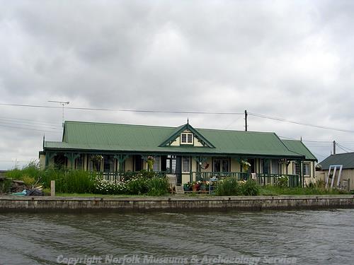
One of the distinctive inter-war chalets built in vernacular style on the River Thurne. (© NCC)
Martham Ferry (NHER
33880) is a floating swing bridge dating to about 1920. Concrete abutments on the banks of the River Thurne are linked by a floating timber platform and a steel winch. The Potter Heigham and Martham chalets (NHER
39354,
39355) were built in the inter-war period in a range of pseudo-vernacular styles. The chalets are built of iron or wood framing and are covered in weatherboarding or painted corrugated iron. Some of the chalets are thatched and have false timber framing. This is the largest concentration of this type of inter-war chalet in Broadland. A World War Two pillbox (NHER
27460) is visible on aerial photographs taken at the end of the war. The pillbox probably defended the access route from Martham to Winterton, but has since been demolished.
An archaeological evaluation carried out by NAU Archaeology in June 2006 at Manor Farm did not reveal any archaeological finds or features except for three small pits that are probably modern in date (NHER 44779).
Sarah Spooner (NLA), 14 June 2006.
Further Reading
Brown, P. (ed.), 1984. Domesday Book: Norfolk (Chichester, Phillimore)
Mills, A.D., 1998. Dictionary of English Place-Names (Oxford, Oxford University Press)
Pevsner, N. and Wilson, B., 1997. The Buildings of England: Norfolk 1: Norwich and North East (London, Penguin)
Rye, J., 1991. A Popular Guide to Norfolk Place-names (Dereham, Larks Press)