This Parish Summary is an overview of the large amount of information held for the parish, and only selected examples of sites and finds in each period are given. It has been beyond the scope of the project to carry out detailed research into the historical background, documents, maps or other sources, but we hope that the Parish Summaries will encourage users to refer to the detailed records, and to consult the bibliographical sources referred to below. Feedback and any corrections are welcomed by email to heritage@norfolk.gov.uk
Marham is a large parish in the west Norfolk district. Situated south of Pentney and north of Barton Bendish it is well known for being the home of RAF Marham. The base occupies much of the chalk upland area in the south part of the parish. The River Nar flows through the north part of the parish and in the northwest an area of fen surrounds the river. To the east Marham Fen has been reverted to fen carr by Anglian Water.
The parish name derives from Old English and means ‘homestead by or with a pond or mere’. Land here is recorded in the Doomsday Book as being owned by St Etheldreda before 1066. In 1087 a mill is recorded. The Fenland Survey project fieldwalked all the available fields in the northwest of the parish. This intensive survey allows us to understand how this part of the landscape was used from the prehistoric period onwards.
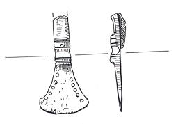
The earliest finds recorded are the prehistoric burnt and worked flints recovered during the fieldwalking survey. These include one Mesolithic site where the assemblage of finds includes flakes, blades and microliths (NHER 24377). This is the only Early Mesolithic site identified in the Nar Valley during the survey. A possible Early to Middle Neolithic settlement (NHER 23437) has also been identified. A concentration of pieces of Neolithic pot, animal bone and Early to Middle Neolithic worked flints was found. Several Neolithic flint axeheads (NHER 3926, 4478 and 4479) and a Neolithic flint chisel (NHER 14806) have also been recorded. Two mounds were recorded in the 19th century but have now been destroyed (NHER 4482 and 4497). These may have been Bronze Age round barrows. The cropmark of a ring ditch (NHER 30849) also possibly belonging to a Bronze Age round barrow has also been located. Bronze Age finds include two axeheads (NHER 4481 and 14432). The Bichamditch or Devil’s Dyke (NHER 3937) is a large linear earthwork that has traditionally been dated to the Early Saxon period but may be Iron Age.

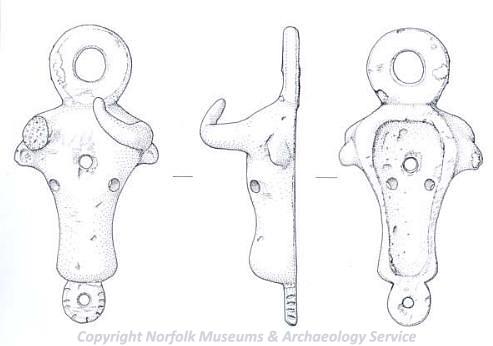
An Iron Age or Roman mount in the shape of a bull's head. (© NCC)
Iron Age finds include a possible torc (NHER 4484) that was simply thrown back into the field by the finder before it could be positively identified by archaeologists. A coin (NHER 33435), brooches (NHER 11461 and 30111) and a vessel mount in the shape of a bull’s head (NHER 29262) also date to the Iron Age. Iron Age pottery has also been identified (NHER 7243, 11461 and 16274). The distribution of these pot fragments suggests that occupation was set back a little from the fen edge allowing the occupants to take advantage of the resources it offered.
The Fen Causeway (NHER 2796) runs through the parish. This Roman road runs from a junction with Ermine Street and King Street near Peterborough across the Cambridgeshire and Norfolk fens. Fieldwalking and metal detecting has also located a possible Roman settlement (NHER 18255). Finds from the settlement include coins, pieces of pot, a finger-ring, a weight and a Roman bracelet. Coins (NHER 13858, 15759, 23734, 33435 and 24545) have also been found at many other sites. Brooches (NHER 24950), a weight with a hanging loop (NHER 34356) and an armlet and nail cleaner (NHER 11461) have also been recovered. These have been recovered by metal detecting in and around Marham suggesting a Roman settlement might lie underneath the later village.

Part of an Early Saxon small-long brooch from Marham. (© NCC)
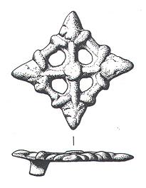
The Bichamditch or Devil’s Dyke (NHER 3937) is a bank and ditch that runs for 11 km between the River Nar at Narborough to the north and a tributary of the River Wissey at Beachamwell. It may have been built by post Roman occupants of west Norfolk and the fens to control movement along the Fen Causeway (NHER 2796) from the east. Finds from the Early Saxon period include two small-long brooches (NHER 4511 and 11461) and a cruciform brooch (NHER 29903). An incomplete Middle Saxon strap end (NHER 24378) and pieces of Middle Saxon pot (NHER 22985) have also been recovered. Metal detecting has recovered two Viking brooches (NHER 4511 and 23366), a strap end (NHER 11461) and a stirrup mount (NHER 35801). Despite these finds and intensive fieldwalking there is no evidence for Saxon settlement.

A bronze lozenge form openwork brooch of Viking type dating to the 9th to 10th century from Marham. (© NCC)
In the medieval period the focus of the settlement was at the southwest end of the modern village. Holy Trinity Church (NHER 4509) is of 14th and 15th century date although it contains fragments of a Norman building. The site of St Andrew’s Church (NHER 4501) is just to the southeast, now within the vicarage garden. Two burials have been found in the garden and earlier finds of burials and coffins have also been recorded. A cross (NHER 4504) perhaps on this site may have marked the location of St Andrew’s. A chapel (NHER 4511) may have stood on Chapel Hill in the medieval to post medieval period.

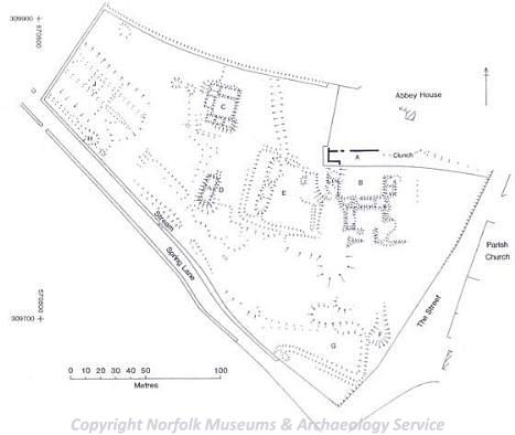
A plan of the earthworks at Marham Abbey. (© NCC)
Opposite Holy Trinity Church is Marham Abbey (NHER 4483). This Cistercian nunnery was dedicated to the Blessed Virgin and Saints Barbara and Edmund. It was founded in 1249 by Isabel, widow of Hugh D'Albini. In 1252 it was formally incorporated into Waverley Abbey, the mother house of the Cistercian order in England. The small abbey housed between ten and fifteen nuns. It was one of only two Cistercian abbeys founded for nuns in England. To the southwest of the abbey is an unusual square earthwork (NHER 13644 and 11462). This has been identified as a ‘castle’. This may be the castle recorded as being constructed illegally by William Belet. If so it was hardly a castle, actually more of a defended moated manor. The site of another moated medieval manor, Shouldham Hall (NHER 44631), is now in the ground of Marham Hall.
Fieldwalking has recovered a scatter of pieces of medieval pottery and prehistoric worked flint and a broad spread of medieval pot, shell, bone and prehistoric burnt flints (NHER 24378). These medieval finds are indicative of a second centre of medieval settlement on the road to Narborough and Swaffham. Other finds include coins (NHER 19539 and 28388), an ampulla or pilgrim’s flask (NHER 7243) and a case for a set of weights (NHER 33613). A papal bull (NHER 23357), a special seal for documents used by the pope, has also been found but the pope who used the seal has not been identified. Two seal matrices (NHER 24949 and 24545) have also been recovered. An archaeological watching brief during the construction of a new water main recovered pieces of medieval window tracery, three medieval floor tiles, a glazed brick, two medieval roof tiles, a piece of medieval pot and a medieval mortar (NHER 29261). These finds may have come from the Abbey.
Post medieval buildings include Marham House (NHER 4502) that stands on the site of an earlier 19th century house. Marham Hall (NHER 4503) is an 18th century building that was extensively extended in the 19th century. Home Farm complex (NHER 40558) was built in 1861. The complex consists of the farmhouse, barn and outbuildings. The site of a smock mill (NHER 17597) and ‘The Temple’ (NHER 4505) are recorded although both buildings have been destroyed. An archaeological watching brief has also recorded a post medieval pit (NHER 41281). This was possibly a cess pit. A post medieval smoker’s tool (NHER 35801) is a fascinating find. The tool contained a seal, pipe tamper and pipe cleaner. The pipe cleaner is now missing.
The most modern site recorded is RAF Marham (NHER 4510). This airfield was first used by the Royal Flying Corps during World War One and continued in use by the Royal Air Force during World War Two and the Cold War. The airfield had three Picket Hamilton forts during World War Two, and a nuclear bomb store from the Cold War. The bomb store is considered to be of national importance. The airfield and the village were protected by a number of pillboxes (NHER 19074, 32399, 32400 and 32401) during World War Two.
Megan Dennis (NLA), 22 May 2006.
Further Reading
Brown, P. (ed.), 1984. Domesday Book, 33 Norfolk, Part I and Part II (Chichester, Philimore)
Marham Parish Council, 2006 ‘Marham Parish Website’. Available:
http://www.marham.org.uk. Accessed: 1 July 2013
Mills, A. D., 1998. Dictionary of English Place Names (Oxford, Oxford University Press)
Rye, J., 2000. A Popular Guide to Norfolk Place-names (Dereham, The Larks Press)