This Parish Summary is an overview of the large amount of information held for the parish, and only selected examples of sites and finds in each period are given. It has been beyond the scope of the project to carry out detailed research into the historical background, documents, maps or other sources, but we hope that the Parish Summaries will encourage users to refer to the detailed records, and to consult the bibliographical sources referred to below. Feedback and any corrections are welcomed by email to heritage@norfolk.gov.uk
The parish of Haveringland is situated to the south of Cawston in east mid Norfolk. Its name comes from the Old English for ‘newly cultivated land of Haefer’s people’. The parish has a long history, and was certainly well established by the time of the Norman Conquest, its population, land ownership and productive resources being recorded in the Domesday Book of 1086.
Evidence of early human activity in the parish comes in the form of two scatters of burnt flints (NHER 7510 and 25307), prehistoric but not closely dateable, which are thought to have been connected with heating water for cooking or other purposes. The earliest finds to which a reasonably accurate date can be ascribed are Neolithic flint axeheads, both flaked (e.g. NHER 7505, 7752 and 11532) and polished (e.g. NHER 7503, 7504 and 7753). The site at NHER 7752 also produced a Neolithic whetstone.

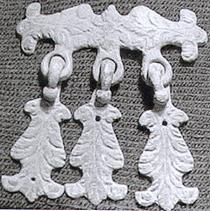
A medieval sword belt hanger from Haveringland.
There is currently no evidence of occupation in the parish during the Bronze Age and Iron Age, and precious little from the Roman occupation. Roman finds are a quern fragment (NHER
7453), coins (NHER
7454,
25308,
33246 and
36612) and pieces of pottery (NHER
7507 and
25308). Saxon finds are also scarce at present, consisting of brooches, a box mount, a piece of pottery (all from NHER
30449), a copper alloy comb (NHER
7465) and a strap end (NHER
33811).
The medieval period has left the parish with its oldest surviving building, St Peter’s Church (NHER 1086). Today standing isolated on a disused World War Two airfield that was once the park to Haveringland Hall (see below), this pretty building has arguably one of the oldest round towers in the county, dating to the 11th century and containing much re-used Roman building material. The rest of the church, including the top of the tower, is a rebuild of 1858, consisting of an aisled nave, chancel and big north and south transepts. The interior is mostly 19th century too, but there is a 15th century font.
Stump Cross (NHER 7464), standing at the side of the Cawston to Norwich road, is the base and part of the shaft of a medieval stone cross.
Other medieval structures have not survived. Mountjoy Priory (NHER 7754), founded by the Augustinians in the 10th century, has disappeared, though medieval pottery and tiles have been found in the area. Sometimes the former presence of buildings can be surmised from cropmarks visible only from the air, as at NHER 34253, which appears as an enclosure mark on aerial photographs. Large quantities of medieval and post medieval pottery fragments found on the ground indicate a medieval house, altered and occupied well into the post medieval period. It is also possible that an entire medieval settlement in the parish has vanished; aerial photographs taken to the west of Great Wood show an area of cropmarks that are probably the traces of a village (NHER 30852), now partly covered in farm buildings.
The first of three buildings known as Haveringland Hall was also medieval (NHER 7521), and although the house itself has long gone, its moat is still there, technically over the parish border in Cawston.
Medieval objects found in the parish include pottery fragments (e.g. NHER 7508 and 12020), coins (e.g. NHER 33246, 33925, 36612 and 44066), a pilgrim bottle (NHER 23463), brooches (NHER 30449) and buckles (NHER 33246 and 33925). The last medieval feature to note is NHER 7509, a flint-lined well excavated in 1958.

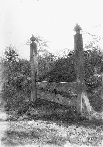
Haveringland stocks, a complete set of oak and wrought iron stocks dating to 1804.
Courtesy of Norfolk County Council Library and Information Service.
The second Haveringland Hall (NHER
7519) was built in about 1580 and demolished in 1840. Cropmarks of its layout can still be seen from the air. The third Hall (NHER
7518) was then built, itself being demolished in 1946, although its stable block remains, now converted to residential use. Probably the oldest post medieval building to survive today is Quakers Farmhouse (NHER
7520), which although later altered, originally dates to about 1700. A watermill marked on a late 18th century map (NHER
15236) has gone, though its millpond remains. An ice house (NHER
13708) is marked on a 19th century map, but is thought to have gone as well. Away from buildings, a remarkable post medieval survival is a complete set of oak and wrought iron village stocks (NHER
28447).
Post medieval objects found in the parish include coins (NHER 33087, 36612 and 44066), a thimble (NHER 33925) and two gunpowder flask nozzles (NHER 44066).
The most historically recent entries on the archaeological record date to World War Two. Swannington airfield (NHER 7465), set in the old parkland of Haveringland Hall, was home to Mosquito and Spitfire squadrons during the war. Although now mostly ploughed up, portions of runway remain and some buildings, including the rifle range complex. A type 22 concrete pillbox (NHER 32499) dating to about 1940 and now much overgrown, was probably part of a defended roadblock for the A1149.
The patchiness of parts of the early archaeological record does not necessarily mean that there was no human activity at those times, and may merely reflect a lack of detailed investigation. The record may well fill out in the future.
Pieter Aldridge (NLA), 19 May 2006.
Further Reading
Brown, P. (ed.), 1984. Domesday Book, 33 Norfolk (Chichester, Phillimore & Co)
Fairhead, H. and Tuffen, R., 1987. Airfields and airstrips of Norfolk and Suffolk (Flixton, Norfolk and Suffolk Aviation Museum)
Rye, J., 1991. A Popular Guide to Norfolk Place Names (Dereham, The Larks Press)