This Parish Summary is an overview of the large amount of information held for the parish, and only selected examples of sites and finds in each period are given. It has been beyond the scope of the project to carry out detailed research into the historical background, documents, maps or other sources, but we hope that the Parish Summaries will encourage users to refer to the detailed records, and to consult the bibliographical sources referred to below. Feedback and any corrections are welcomed by email to heritage@norfolk.gov.uk
The tiny parish of Hellington is situated in southern Norfolk, about five miles southeast of Norwich. Its name comes from a combination of Old Norse and Old English, meaning ‘Helgi’s farmstead’ or ‘Helgi’s hill spur settlement’. Though small, the parish has a long history of human occupation, and was certainly well established by the time of the Norman Conquest, its population, land ownership and productive resources being recorded in the Domesday Book of 1086.
Prehistoric worked flint tools have been found in the north part of the parish (NHER 33755), but the earliest dateable evidence of human activity comes in the form of a Mesolithic flint arrowhead and blades (NHER 10306). An arrowhead and scrapers (NHER 10307) found in the southwest of the parish might be Neolithic, but could equally well be Bronze Age. There are no more finds from either period at the moment, but there is tentative evidence of the first structures in the parish. These are ring ditches, probably Bronze Age round barrows subsequently flattened by agriculture, and only visible as cropmarks on aerial photographs. Two of these have been noted in the west of the parish (NHER 16444). There are currently no finds from the Iron Age, and the only Roman find is a lead dolphin figure (NHER 34928) found to the east of Rookery Farm. Saxon finds are a couple of Late Saxon brooches (NHER 23409 and 34928) and some fragments of Late Saxon pottery (NHER 23264).

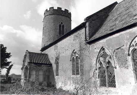
St John the Baptist's Church, Hellington. (© NCC.)
The medieval period has left the parish with its oldest surviving building, the church of St John the Baptist (NHER
10334). This isolated church is architecturally very interesting, much money having been lavished on it by the Kerdiston family in the 14th century, and although added to and altered in the 17th and 19th centuries, much of their work remains. The church consists of a round west tower, nave, chancel and a very unusual south porch. The tower has possible Norman origins, but the decorated north and south doors are definitely Norman, and are fine examples. The rest of the church is fairly elaborate 14th century work. The south porch east and west walls each have three large open niches, somewhat out of proportion to the rest of the building and possibly brought in from elsewhere. Now in the care of the Churches Preservation Trust, the building was renovated in the 1990s.
There are no other surviving medieval buildings in the parish, but medieval finds include pottery fragments (NHER 23264, 23409 and 33755), coins (NHER 23264, 34928, 34929 and 36078), buckles (NHER 34929) and a harness pendant (NHER 34928).
Two post medieval buildings in the parish are worth mentioning. The Rookery (NHER 19558) is a late 17th century rendered brick farmhouse, probably standing on the site of an earlier manor, with a 19th century extension. Some older features remain inside, including the staircase and a fine fireplace in the south ground floor room. Church Farm (NHER 20034) is a late 18th century former farmhouse with associated barns and buildings, including a cottage where a witch bottle was found under a hearth during renovation work in 1976. The bottle, late 17th century in date, contained fragments of a 15th or 16th century devotional book, and was designed to ward off evil spirits. Apart from this bottle, other post medieval finds consist of coins (NHER 23264, 23409, 34928 and 36078).
The most historically recent entry on the record for the parish is a World War Two concrete pillbox (NHER 32577), set in the southeast on Green Lane. This was built in about 1940 as part of the anti invasion defences of the time. Most of its external brickwork has now fallen off.
The relatively small number of records for the parish may just be due to its size, but could also reflect a lack of detailed investigation. The picture may well change in the future.
Piet Aldridge (NLA), 18 April 2006.
Further Reading
Brown, P. (ed.), 1984. Domesday Book, 33 Norfolk (Chichester, Phillimore & Co)
Mills, A., 1998. Oxford Dictionary of English Place Names (Oxford, University Press)
Rye, J., 1991. A Popular Guide to Norfolk Place Names (Dereham, The Larks Press)