This Parish Summary is an overview of the large amount of information held for the parish, and only selected examples of sites and finds in each period are given. It has been beyond the scope of the project to carry out detailed research into the historical background, documents, maps or other sources, but we hope that the Parish Summaries will encourage users to refer to the detailed records, and to consult the bibliographical sources referred to below. Feedback and any corrections are welcomed by email to heritage@norfolk.gov.uk
Kirstead is a small parish in south Norfolk. Modern settlement is fairly dispersed, and is strung out along a series of former greens shown on Faden’s map of 1797. Kirstead comes from the Old English meaning ‘site of a church’. The lost settlement of Langhale was in the southeast of the parish, and the name derives from the Old English meaning ‘a long nook (of land)’.
The earliest archaeological find recovered from the parish is a Bronze Age rapier (NHER 10449) found by a metal detectorist. Roman coins (NHER 10142, 10449, 19768, 31098, 31099, 32923), pottery (NHER 10449, 29314), a terret (NHER 10449) and a spindle whorl (NHER 33203) have also been found.
In 1086 Kirstead was held by the Abbey of St Edmunds, and had 2 villagers and 11 smallholders. Langhale was held both by the Abbey and by a man named Isaac, who held 6 freemen and 3 smallholders. A church is mentioned in the Domesday Book, but it is unclear whether it refers to Langhale or Kirstead.
The lost Late Saxon and early medieval settlement of Langhale appears to have been quite dispersed, and concentrations of pottery have been found near Moat Farm and Bethel Farm (NHER 10454 and 10144). In the 1970s the site of a Late Saxon or early medieval pottery kiln (NHER 5108) was excavated on Seething Road. The excavation also discovered the remains of a structure that had been built by the end of the 12th century, and three medieval ditches. An earthwork ditch runs parallel to the road, and has been interpreted as a probable Late Saxon to medieval common boundary. The parish church of Langhale was dedicated to St Christopher (NHER 10144) and was united with Kirstead in the early 15th century. The church building was in ruins by the 17th century and there are now no upstanding remains, although medieval pottery, building foundations and human remains have been found on the site since the 1930s. A number of linear earthworks (NHER 10452) are visible in the fields near Langhale House. These earthworks were once thought to relate to the medieval village of Langhale but they are more likely to be medieval or post medieval field boundaries.

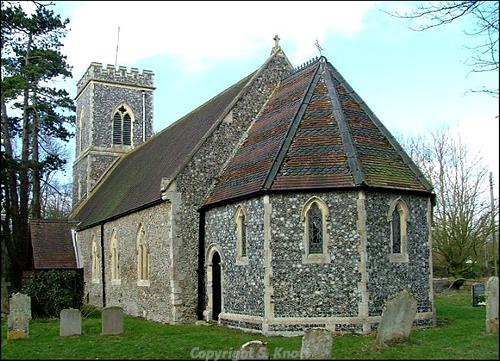
St Margaret's Church,. Kirstead. This medieval parish church dates back to about 1200. Photograph from www.norfolkchurches.co.uk (© S. Knott.)
St Margaret’s Church, Kirstead (NHER
10159), dates back to about 1200. The church was extensively restored in 1864, when the west tower, the chancel and the nave windows were all replaced. The remains of a medieval moated site (NHER
10145) survive at Moat Farm. The west arm is still water-filled, and timber and flint revetting has been found on the sides of the moat. A second medieval moat (NHER
31870) has survived as earthworks near Pever’s Farm, and fragments of medieval pottery have been found on the site. The earthworks of another medieval moat and a trackway (NHER
29784) are visible on aerial photographs south of Kirstead House Farm. Fragments of medieval pottery (NHER
10446) and medieval metal finds including a shield shaped strap fitting (NHER
31598) and a late medieval spur (NHER
28344) have been found in the parish.

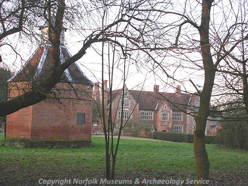
Kirstead Hall and dovecot. (© NCC)
Walnut Tree Farmhouse (NHER
10450) is a 16th century timber framed house with a 17th century cross wing. The doorstep of the house was made from a piece of reused medieval stonework inscribed ‘for the poor and infirm’. Kirstead House Farmhouse (NHER
14049) is a 17th century timber framed house with elaborate plaster ceilings and a long wooden 17th century bench built into the kitchen. Windetts Farm Cottages (NHER
34088) are two early 17th century houses that are now divided into four cottages. Numbers 1 and 2 were converted into a threshing barn in the 18th century, and the timber frame of numbers 3 and 4 were partially replaced by brick in the 19th century. Kirstead Hall (NHER
10153) is a 17th century house that probably incorporates parts of an earlier building. The house has crowstepped gables and diapered brickwork, and the stables, barn and forecourt walls all date to the 17th century. Green Man House (NHER
14046) is a former public house, built in the 18th century and marked on Faden’s map of 1797.
Sarah Spooner (NLA), 11 May 2006.
Further Reading
Brown, P. (ed.), 1984. Domesday Book: Norfolk (Chichester, Phillimore)
Mills, A. D., 1998. Dictionary of English Place-Names (Oxford, Oxford University Press)
Rye, J., 1991. A Popular Guide to Norfolk Place-names (Dereham, Larks Press)
Wade, K. 1976. 'Excavations at Langhale, Kirstead', East Anglian Archaeology 2