This Parish Summary is an overview of the large amount of information held for the parish, and only selected examples of sites and finds in each period are given. It has been beyond the scope of the project to carry out detailed research into the historical background, documents, maps or other sources, but we hope that the Parish Summaries will encourage users to refer to the detailed records, and to consult the bibliographical sources referred to below. Feedback and any corrections are welcomed by email to heritage@norfolk.gov.uk
The modern parish of Howe is southeast of Norwich, situated between Poringland and Brooke. The hamlet of Howe is located in the northeast, alongside Howe Green. The rest of the parish is mostly arable land, with a few farms and houses scattered elsewhere.
Howe has seen some archaeological work. A fair amount of metal detecting has taken place, as has some fieldwalking. An excavation has been conducted at St Mary’s Church and a number of site visits have taken place. Nearly all of the identified sites are located close to the hamlet, with only one site definitely situated elsewhere. As a result, the following discussion focuses strongly on the northeastern area.
Prehistoric flint artefacts have been discovered and include flakes, cores, a Neolithic polished axehead (NHER 13850) and a Neolithic or Bronze Age scraper. A fragment of Neolithic or Iron Age pottery has been found north of the hamlet, with pieces of Iron Age pottery collected to the southeast. During the 19th century an Iron Age loomweight was gathered, but exactly where is uncertain and it is possible that it came from neighbouring Brooke.
The Roman road (NER 10160) from Caistor St Edmund to Dickleburgh may have passed through the west of the parish. Metal detecting, field observations and an excavation (NHER 15195) at a site west of the possible road and southeast of the hamlet have revealed evidence for intensive Roman activity. Building material, pottery, metalwork and a pit seen in the side of a ditch suggest the presence of buildings and a settlement. A dispersed coin hoard buried amongst the buildings in the late 1st century AD was found in 1981. The Roman tiles and bricks in the walls of St Mary’s Church (NHER 10128) may have come from the settlement. Artefacts discovered at other sites in the northeast include pottery, coins and a terret and they probably represent activity around the settlement.
During the 19th century brooches, wrist clasps, a girdle hanger, shield bosses, spearheads and glass beads were recovered from an Early Saxon inhumation and cremation cemetery (NHER 10132). Unfortunately its exact location is not known and although it may have been in Howe, it could have been in Brooke. A brooch found by a metal detectorist in 1994 is the only Early Saxon object definitely discovered in the parish.

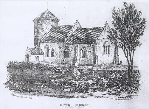
St Mary's Church, Howe, a Late Saxon, medieval and later parish church.
Middle Saxon pottery has been found at two sites close to the hamlet, with Late Saxon pottery found at three. A 10th century strap end, a brooch and a box mount have also been discovered. Parts of St Mary’s Church (NHER 10128) are Late Saxon, with the round tower and nave dating to around 1050. The chancel, porch and some nave windows were added in about 1300. The medieval north chapel or aisle has been demolished, although excavations in 2003 uncovered walls and part of a tiled floor from it. This work also revealed two infant skeletons and an 18th century vault that was used by Anna Sewell’s family.
In the Domesday Book of 1086 Howe was called ‘Hou’. This is an Old Scandinavian name meaning the ‘place at the hill or burial mound’. Land in the parish was held by King William I and Bury St Edmunds Abbey. Villagers, smallholders, slaves, ploughs, woodland, meadow, pigs, cattle and sheep were recorded. A church is noted and this probably a reference to St Mary’s.
There is surviving evidence for medieval houses in the hamlet. In the west of the hamlet a medieval timber framed wall (NHER 33515) survives inside a modern house. In 1987 it was part of a cottage that was damaged during the severe autumn gales. The wall was the only section to survive and it was subsequently built into the modern house. The main block of Church Farmhouse (NHER 36206) was originally a hall house and although the date at which it was built is uncertain, it may have medieval features. Alterations were made during the 17th, 18th and 19th centuries.
A large irregular shaped pond north of Howe Hall (NHER 14052) could be the remnants of a medieval moat. The timber framed hall itself was built in the late 16th or early 17th century. It has a façade that was added during the late 18th century and a 17th century brick rear wing. Other post medieval buildings include a 17th or 18th century house at Wolferd Green, Pearl Cottage (which was built around 1600) and the 18th to 20th century Rectory Cottage.
Many medieval and post medieval artefacts have been reported. They include pottery fragments, seal matrixes, coins, buckles, a stylus, a figure of Christ from a crucifix and a pewter spoon. There was a post medieval gravel quarry (NHER 9909) in the northeast. It survives as a large pond.
David Robertson (NLA), 31 March 2006.
Further Reading
Anonymous, 1981. The village of Howe (Howe, St Mary’s Church)
Ashwin, T. & Davison, A., 2005. An Historical Atlas of Norfolk (Chichester, Phillimore)
Barringer, C., 1989. Faden’s Map of Norfolk (Dereham, Larks Press)
Brown, P. (ed.), 1984. Domesday Book: Norfolk (Chichester, Phillimore)
Mills, A.D., 1998. Dictionary of English Place-Names (Oxford, Oxford University Press)
Knott, S., 2006. 'St Mary’s, Howe'. Available:
http://www.norfolkchurches.co.uk/howe/howe.htm. Accessed: 30 March 2006.
Rye, J., 1991. A Popular Guide to Norfolk Place-names (Dereham, Larks Press)