This Parish Summary is an overview of the large amount of information held for the parish, and only selected examples of sites and finds in each period are given. It has been beyond the scope of the project to carry out detailed research into the historical background, documents, maps or other sources, but we hope that the Parish Summaries will encourage users to refer to the detailed records, and to consult the bibliographical sources referred to below. Feedback and any corrections are welcomed by email to heritage@norfolk.gov.uk
The modern parish of Honingham is located in Breckland, west of Norwich and east of Dereham. The village is situated in the west to the south of the A47. The River Tud passes through the centre of the village and it meanders east to west through the parish. Farms are scattered throughout and the hamlet of Colton encroaches into the south.
Honingham has seen a considerable amount of archaeological work. A lot of fieldwalking has taken place, especially in the east. Plenty of sites visits have been carried out and many stray finds are recorded. There has been some metal detecting and a number of small excavations. Sites have been identified in most parts of the parish, although there are a few places were none have been recorded.
A large number of prehistoric flint artefacts have been discovered and they include a Mesolithic macehead (NHER 13328), at least seven Neolithic polished axeheads and many flakes, blades, scrapers and cores. Three sites in the northeast (NHER 16389, 16390 and 16391) have produced numerous Early Neolithic flints. At two of these sites over three hundred flakes have been discovered and Neolithic pottery has been found at one. Pottery of Neolithic, Bronze Age or Iron Age date has been found at three sites. A probable prehistoric pit was excavated during a watching brief on the Honingham to A47 Anglian Water pipeline (NHER 29151).

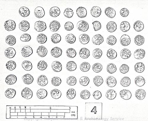
Iron Age coins from the Honingham hoard. The hoard containing over 300 silver units was found in 1954. It was buried, inside a pot, in the 1st century AD. (© NCC.)
Five ring ditches (NHER
12807,
12808 and
12809) are visible as cropmarks on aerial photographs. All are probably the remains of Bronze Age barrows and are located on land that slopes up from the River Tud. One is situated to the north of the river, with four to the south. The northern ring ditch has a circular mark at the centre that could be an inhumation burial. Bronze Age copper alloy socketed axeheads and a copper alloy palstave have been found in the parish. In 1954 a farmer uncovered a pot that contained a hoard of Iron Age Iceni coins (NHER
7818). Excavations followed and over 300 coins were gathered. The hoard was buried after AD 45 and possibly during the Boudican revolt of AD 60/61. Three coins found by metal detecting in the 1980s probably also came from it.
Few Roman objects have been discovered, with only a few pieces of pottery, a coin, a brooch and a cosmetic mortar reported. As quite a lot of fieldwalking has taken place, the low number of artefacts may truly represent a lack of activity and settlement rather than a lack of investigation.
Early and Late Saxon pottery (NHER 17163) have been found in the east, northeast of St Andrew’s Church. Possible Middle Saxon pottery, a Middle or Late Saxon pin and a set of Middle to Late Saxon tweezers have been discovered near the church and the River Tud. Although few in number, these finds suggest that during the Saxon period there was activity, and possibly settlement, close to the site of the church.
In the Domesday Book of 1086 Honingham was called ‘Hunincham’. This Old English name means ‘the homestead of Huna’s people’. In 1086 Count Alan held land in the parish. Part of his estate was called ‘Thorp’ and another section was linked to estates at Costessey. Freemen, villagers, smallholders and a plough were listed.

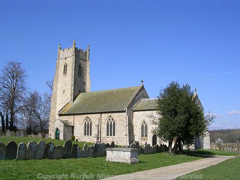
St Andrew's Church, Honingham. (© NCC.)
St Andrew’s Church (NHER
7823) now stands in an isolated position by the A47. It is a medieval church that was greatly restored during the 19th century. Some of the windows date to the early 14th century and at least part of the tower is 15th century. Inside are 16th century brasses and a number of 17th century monuments. To the east of the church enclosures (NHER
28552) are visible on aerial photographs. It is possible that they were part of a medieval toft. Medieval and post medieval objects, including pottery, coins and buckles, have been found.
Honingham Hall (NHER 7821) was built in 1605, remodelled during the 19th century and demolished in 1967. It may be visible as parchmarks on aerial photographs. A 17th century stable block, coach house and walled yard are all that remain and there is an associated icehouse to the east. Faden’s map of 1797 shows that by the end of the 18th century the hall was surrounded by a landscape park (NHER 44183). The large lake to the south of the hall was part of this and a surviving hydraulic ram (NHER 7824) was sited within it.

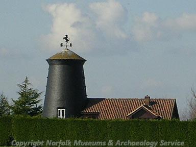
Honingham Windmill. (© NCC.)
There is a post medieval miller's house in the village. It stands beside the River Tud, adjacent to the site of a now demolished watermill (NHER
7825). Close by are a 17th century timber framed house (NHER
12610), the site of a 17th century timber framed house that was demolished in the late 1970s and a 19th century windmill (NHER
7826). In 1788 a windmill was built to the south of the village, but this has been demolished.
Church Farm and Greenacres Farm both have 17th to 18th century and later buildings. One of the barns at Church Farm (NHER 37298) features 16th or 17th century work. A 19th century oasthouse (NHER 12611) survives at Hall Farm. It is built of brick, is round and has a conical tile roof. It is the only surviving oasthouse in Norfolk and possibly the only surviving example in East Anglia. At Telegraph Hill (NHER 22729) is the site of a late 18th to early 19th century station on the London to Great Yarmouth telegraph.
Part of ‘Attlebridge Airfield’ (NHER 3063) occupies the northwest corner (the rest of it is located in East Tuddenham, Hockering and Weston Longville parishes). During World War Two both the RAF and the United State Army Air Force used it. Surviving features in the parish include air raid shelters, two fuel stores, a building, two possible searchlight or gun positions, a sewage works and the remains of sentry boxes. A probable World War Two searchlight battery is visible in Honingham Park on aerial photographs taken in 1946. Fragments of World War Two ammunition (NHER 17163) have been found and they suggest that at least some of the surrounding area was used as a firing range.
Honingham water tower (NHER 40216) was built in 1980. It is of a unique design and has a central shaft surrounded by three linked shafts.
David Robertson (NLA), 23 March 2006.
Further Reading
Ashwin, T. & Davison, A., 2005. An Historical Atlas of Norfolk (Chichester, Phillimore)
Barringer, C., 1989. Faden’s Map of Norfolk (Dereham, Larks Press)
Brown, P. (ed.), 1984. Domesday Book: Norfolk (Chichester, Phillimore)
Mills, A. D., 1998. Dictionary of English Place-Names (Oxford, Oxford University Press)
Neville, J., 2003. 'Honingham Mill'. Available:
http://www.norfolkmills.co.uk/Watermills/honingham.html. Accessed: 23 March 2006.
Neville, J., 2005. 'Honingham towermill'. Available:
http://www.norfolkmills.co.uk/Windmills/honingham-towermill.html. Accessed: 23 March 2006.
Rye, J., 1991. A Popular Guide to Norfolk Place-names (Dereham, Larks Press)