This Parish Summary is an overview of the large amount of information held for the parish, and only selected examples of sites and finds in each period are given. It has been beyond the scope of the project to carry out detailed research into the historical background, documents, maps or other sources, but we hope that the Parish Summaries will encourage users to refer to the detailed records, and to consult the bibliographical sources referred to below. Feedback and any corrections are welcomed by email to heritage@norfolk.gov.uk
The modern parish of Hoe is located in Breckland, directly north of Dereham. It was created in the mid 20th century from the two former parishes of Hoe and Worthing and as a result has an unusual shape. Some of the northern boundary follows the River Wensum. Sections of the northern and eastern boundaries follow the River Blackwater and one of its tributaries. Settlement is generally scattered throughout, with the hamlets of Hoe in the southeast and Worthing in the north.
Hoe has seen a reasonable amount of archaeological work. A number of excavations have taken place, including a series of investigations ahead of gravel extraction at a quarry adjacent to Swanton Morley airfield. Plenty of sites visits have been carried out and a few stray finds are recorded. A limited amount of metal detecting and fieldwalking has taken place. Sites have been identified in most parts of the parish, although there are a few places where none have been recorded.
Only a few prehistoric flint artefacts have been discovered and these include part of a Mesolithic axehead, a Neolithic polished axehead fragment, a Neolithic flaked axehead, Neolithic scrapers and pot boilers. A Middle Bronze Age copper alloy palstave (NHER 29159) has been found in the west and in 1898 a hoard of Late Bronze Age objects (NHER 2790) was recovered, although the exact location and nature of its discovery are uncertain. It comprised ten socketed bronze axeheads and four ingots.
It is reported that a barrow (NHER 2789), probably of Bronze Age date, was destroyed around 1845 and that several urns were collected from it. Its exact site is uncertain, although it may have been located to the north of Hoe hamlet. Three ring ditches, probable Bronze Age barrows, have been identified on aerial photographs. One is located close to the destroyed barrow, with one in the west and one at Swanton Morley airfield. Two possible Bronze Age hearths or burnt mounds have been recorded in the northwest. Flint scrapers and Beaker pottery were recovered from one of them (NHER 2786). Excavations ahead of gravel quarrying on the edge of Swanton Morley airfield have revealed Bronze Age and Iron Age pottery, a Bronze Age pit (NHER 32147) and two Late Bronze Age or Iron Age pits (NHER 37159). A metal detectorist has found an Iron Age Iceni coin (NHER 29159) in the northwest.
Excavations in 2002 and 2003 on the edge of Swanton Morley airfield revealed a possible Roman field system, three Roman kilns, pottery and coins (NHER 37159). The kilns dated to the first half of 2nd century AD and produced coarse ware pottery. Between 1947 and 1950 a parade helmet, the visor from a second parade helmet and the remains of a 2nd century AD timber bridge were discovered during dredging of the River Wensum (NHER 2984). Both the helmet and the visor are made from brass and are elaborately decorated, while the thinness of the metal suggests that they were used during parades, sports or exercises. The decoration and shape suggests that they could date from the 2nd half of the 3rd century AD. Roman objects collected at other sites include coins, pottery and a terret.
The 2002 and 2003 excavations also discovered an Early Saxon cemetery and settlement (NHER 37159). Ten cremations, one inhumation, grubenhauser (sunken featured buildings), post holes and pits were recorded and pottery and metalwork were collected. The only other Early Saxon discovery is a brooch that was found by a metal detectorist. Possible Late Saxon pottery has been found adjacent to St Margaret’s Church, Worthing.
Hoe appears in the Domesday Book of 1086 as ‘Hou’. This is an Old English name meaning ‘hill spur’ or ‘ridge of land’. Land in the parish was held by the Abbot of Ely and was linked to estates at Dereham and Mileham. Worthing was not described in 1086, although this does not mean that the parish of Worthing or a settlement with that name did not exist. Worthing probably comes from the Old English ‘worthign’ meaning ‘open place or yard around a homestead’.
Both St Margaret’s Church, Worthing and St Andrew’s, Hoe have features that could be Late Saxon in date. The round tower and nave at St Margaret’s (NHER 2829) probably date to the 11th or 12th century, although they do have later features. The tower was reduced in height during the 18th century and the chancel was demolished between 1781 and the 1820s. The lower section of the tower and the west wall at St Andrew’s (NHER 2833) have 11th or early 12th century elements. The entire nave except the west wall was rebuilt in 1794 and the chancel was entirely rebuilt in 1820. The upper section of the tower had been removed by 1740, rebuilt by 1823 and removed by 1902.
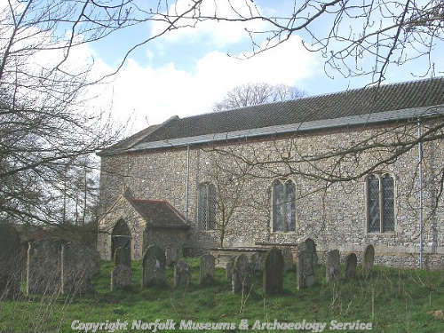
St Andrew's Church, Hoe. (© NCC.)
During the medieval period Hoe hamlet was bigger than it is today and settlement earthworks (NHER
2810) survive to the north and east of St Andrew's Church. They include a moat, hollow ways, enclosures, probable tofts and a possible windmill mound. Three possible moats have been identified. One was located north of Hoe Hall (NHER
2832), with the others in the west (NHER
12238) and close to Worthing hamlet (NHER
2811) respectively. A ruined chapel noted around 1740 may have stood at the Worthing site, although it is more likely that it was located immediately adjacent to the St Andrew’s Church.
In 1947 the evidence for a possible medieval watermill (NHER 2984) was discovered during dredging of the River Wensum. Bricks, tiles and medieval and post medieval pottery have been found in the south and may indicate the location of a building. Medieval and post medieval objects have been collected throughout and include pottery, coins, a 13th century gold ring and an ampulla.
The western part of Hoe Hall (NHER 2832) was built in the late 16th or 17th century and the eastern section dates from the early 19th century. During the 19th century a landscape park (NHER 44026) may have been laid out around it. Gorgate Hall (NHER 2834) may have been constructed in the early 18th century and its brick façade dates to the 19th century. The Old Manor House (NHER 14244) is timber framed, has an 18th or 19th century facade and includes elements from 16th or 17th century windows.
The site of a windmill is marked close to Gorgate Hall on Faden’s map of 1797. The same map shows a brick kiln in the southwest, at a site where a brickworks (NHER 14159) appears on the 1840s tithe map. A post medieval road (NHER 31676) survives as a hollow way across Hoe Rough. It is shown on a 1830s map and as a footpath on a 1928 map. Undated building material observed beside it may come from buildings. From the early 19th century through until 1950 there was a tannery in Worthing (NHER 15386). At Angel Farm there is a telephone box (NHER 43193) that was designed in 1935 by Sir Giles Gilbert Scott.
Swanton Morley airfield (NHER 2830) occupies much of the former parish of Worthing. It was established as an RAF station in 1939/1940 and during World War Two it had the largest grass airstrip in Europe, a perimeter track and buildings including a control tower, hangars, barracks, messes, Pickett Hamilton forts and pillboxes. Some of the buildings survive and the grass airfield is the only one of its kind to survive in Britain. During World War Two a bomber group used the airfield and in June 1942 the first joint British-American bombing raid was launched from it.
During World War Two there was an antenna array (NHER 40950) in the southeast. A pillbox and an Allan Williams turret were built in the south close to the B1110 and a pillbox and a gun emplacement were constructed by the railway near Hoe Hall. There were practice trenches and butts on Hoe Common and a possible Home Guard Headquarters in Worthing hamlet. On 27 March 1944 a Liberator aircraft crashed in the west following a mid air collision with another Liberator. Both flew from the United States Army Air Force station at ‘Attlebridge’ (NHER 3063, in Weston Longville and other parishes).
David Robertson (NLA), 16 March 2006.
Further Reading
Ashwin, T. & Davison, A., 2005. An Historical Atlas of Norfolk (Chichester, Phillimore)
Barringer, C., 1989. Faden’s Map of Norfolk (Dereham, Larks Press)
Brown, P. (ed.), 1984. Domesday Book: Norfolk (Chichester, Phillimore)
Mills, A. D., 1998. Dictionary of English Place-Names (Oxford, Oxford University Press)
Rye, J., 1991. A Popular Guide to Norfolk Place-names (Dereham, Larks Press)