This Parish Summary is an overview of the large amount of information held for the parish, and only selected examples of sites and finds in each period are given. It has been beyond the scope of the project to carry out detailed research into the historical background, documents, maps or other sources, but we hope that the Parish Summaries will encourage users to refer to the detailed records, and to consult the bibliographical sources referred to below. Feedback and any corrections are welcomed by email to heritage@norfolk.gov.uk
Heacham is a parish in the northwest of the county, on the coast near Hunstanton. Heacham was just a small village on 19th century Ordnance Survey maps and Faden’s map of 1797 but grew rapidly over the 20th century and is popular with tourists and holidaymakers.
The cropmarks of three late prehistoric postholes or pits (NHER 26829) and a late prehistoric trackway (NHER 26885) are visible on aerial photographs. Palaeolithic flint handaxes (NHER 1399 and 1400), a Mesolithic tranchet axehead (NHER 1401) and Mesolithic flakes (NHER 1400 and 1402), Neolithic flint axeheads (including NHER 1404, 1411, 1413, 1414, 1417, 1420, 14703 and 17754) and other Neolithic flint implements including scrapers, cores and arrowheads (NHER 1405, 1406, 1407, 1415, 1418, 1421 and others) and a fragment of Neolithic pottery (NHER 1409) have been found. The skeleton of a woman (NHER 14065) was found in 1973 during building work, and has been dated to the Late Neolithic period.
An excavation in the 1950s revealed flint flakes and a Beaker pottery vessel that may have been associated with a burial, or a possible settlement (NHER 1416). Two ring ditches, probably the remains of Bronze Age round barrows, are visible as cropmarks on aerial photographs (NHER 19280 and 26879). Another Bronze Age round barrow survives as an earthwork (NHER 26867). A Bronze Age or Iron Age urned cremation (NHER 1401) was found before 1911 on the site of Heacham First School. Bronze Age and Iron Age pottery has also been found at the school. Beaker barbed and tanged arrowheads (NHER 1402, 1412) and a Late Bronze Age socketed axehead (NHER 1438) have been recovered from the parish.
A series of Iron Age pits (NHER 1424) were excavated in 1954, and the skeleton of a pig and a human child were found buried together, as well as other human remains, prehistoric flints and pottery. Other Iron Age to Roman pits (NHER 1425) were excavated in 1956 during the construction of a bypass, and Iron Age and Roman pottery was found, as well as an Early Saxon bead. Several Iron Age to Roman settlements (NHER 25905 and 29562) are visible as cropmarks on aerial photographs.

The cropmarks of a Late Iron Age to Roman enclosure and three round houses. (© NCC.)
A complex set of enclosures and field systems (NHER 13032) includes an enclosure that has three round houses within it, and Iron Age and Roman pottery has been found on the site. Another Iron Age to Roman settlement is also surrounded by enclosures and field systems (NHER 19279). Other Iron Age to Roman field systems, trackways and enclosures (NHER 26818, 26881, 26833, 26819, 26868, 26869 and 42520) are also visible as cropmarks. An excavation before 1952 revealed Roman pits and floor surfaces (NHER 1438), as well as Roman pottery, tiles, coins and other metal finds. The course of the medieval Brabons Dyke has been interpreted as following the course of a possible Roman road (NHER 4370).
Iron Age pottery (NHER 1426, 1427 and 28850), including a complete Iron Age vessel (NHER 14550) and Iron Age coins (NHER 16297, 37217 and 40527) have been found. A hoard of seven gold Iron Age coins (NHER 28850 and 33629) was found by a metal detectorist in the early 1990s. Roman pottery (NHER 1427, 1401, 1402, 1424, 1430 to 1432 and 1434), coins (NHER 1422, 1423, 1435, 1436, 1440, 1441, 1481, 12480, 14064, 17007 and 22896), brooches (NHER 1446, 33629 and 33630) and other metal finds (NHER 28850, 40527 and 42580) including part of a Roman statuette (NHER 33629) have been recorded.
The site of an Early Saxon inhumation cemetery (NHER 37217) has been revealed by metal detecting, and a number of Early Saxon brooches and other metal finds have been recovered from the site. Other Early Saxon brooches (NHER 1430, 28503, 28850 and 41986) have also been found, as well as pottery (NHER 1429 and 17754), a pair of tweezers (NHER 16297). A Middle Saxon brooch and pin (NHER 37217), a strap fitting (NHER 28850, pottery (NHER 1439) and some Middle Saxon coins that may have been part of a hoard (NHER 16297) have been found by metal detecting, as well as a large Middle Saxon buckle (NHER 24149) decorated with gilding and niello inlay. The buckle may have been designed to hold a relic. Late Saxon metal finds (NHER 37217, 16297, 28850 and 40265), pottery (NHER 13007, 16297, 17027, 17755 and 28547), and a ring (NHER 33630) have been recovered from the parish.
Heacham comes from the Old English meaning ‘homestead with a hedge’. Heacham is recorded as a fairly substantial holding in the Domesday Book, with at least seventy smallholders and thirty-five freemen. A salt house is also recorded in the Domesday Book and a Late Saxon or medieval salt works (NHER 1439) is visible on aerial photographs.
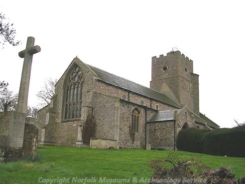
St Mary's Church, Heacham. (© NCC.)
St Mary’s Church (NHER 1486) is a 13th century parish church, with 15th century alterations. A memorial inside the church commemorates nine people who were drowned in a boating accident in 1799. A monastic cell (NHER 1444) was founded in the parish by the Cluniac order in the 11th century, and earthwork banks have been noted on the site. A medieval chapel (NHER 1446) dedicated to the Virgin Mary was founded in 1249. The chapel stood in the east of the parish, and medieval floor tiles have been ploughed up.
Medieval building material (NHER 1452) has been found close to Caley’s Mill, suggesting that medieval settlement once extended into this area of the parish. An evaluation in 2002 at Mill House revealed medieval pits (NHER 37077), as well as an area of medieval ploughsoil that showed evidence of crops not being harvested and being allowed to rot in the ground. A complex of medieval enclosures (NHER 27731) on the edge of Heacham Park are visible as earthworks on aerial photographs. The enclosures were probably associated with a medieval manorial site, or a monastic grange.
The possible site of Thorpe watermill (NHER 1457) is on the edge of Heacham Park, and medieval masonry has been found in the river bank. A medieval fishpond or mill leat (NHER 1454) is visible as an earthwork close to the possible site of the watermill. Another watermill (NHER 16297), possibly dating to the medieval period, is shown on Faden’s map of 1797. An earthwork mound (NHER 26836), probably a medieval mill mound, is on the banks of Heacham River close to the parish boundary. Various medieval to post medieval field boundaries and drainage ditches are visible as cropmarks and earthworks on aerial photographs, as well as medieval to post medieval oyster beds (NHER 1460 to 1462), water meadows (NHER 33387, 26835, 26837 and 26840) and ridge and furrow (NHER 27733 and 26816).
Norfolk Cottage (NHER 30402) is a 16th century house that may have originally been timber framed. The house may be the surviving service end of a late medieval house that was refronted in the 18th century. Manor Farm (NHER 1448) is a 17th century house with 19th century alterations. Church House (NHER 43159) is an early 17th century house that has also been used as a barn. The High House (NHER 10507) is an early 18th century house, and early 18th century wooden carvings were found in the wall of an 18th century barn at Caley Farm. Heacham Hall (NHER 12481) was an 18th century hall with later extensions, probably built on the site of an earlier building. The Hall was destroyed by fire during World War Two, and only the stables, kitchen and other outbuildings survive. Heacham Park (NHER 30507) is a late 18th century landscape park that expanded during the 19th century.
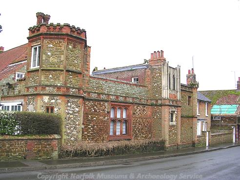
Turret House, Heacham. (© NCC.)
Heacham Brickworks (NHER 1422) is shown on Faden’s map of 1797. The brick making industry in Heacham was revitalised in the 19th century, and a number of new buildings and kilns were built on the site. The brickworks closed in 1914. Caley’s Mill (NHER 13131) is a 19th century watermill that incorporates some 17th century details. The mill has a four-storey porch tower, and is now the headquarters of Norfolk Lavender. Turret House (NHER 41386) is an unusual 19th century house with a two-storey tower, four angle turrets and various Gothic architectural details. The house incorporates some medieval stonework. Waterloo Bridge (NHER 43165) is an early 19th century carrstone bridge in the Gothic style.
During World War Two a network of defences was constructed around the Norfolk coast. Many of these defences are visible on aerial photographs taken in 1946, and some are still standing. These defences included pillboxes (NHER 23515, 23516, 26828 and 26856), spigot mortar emplacements (NHER 23515), anti tank cubes (NHER 32385), gun emplacements (NHER 26841, 26872 and 26875) and other beach defences (NHER 26858, 26804, 41419 and 41420).
Sarah Spooner (NLA), 28 February 2006.
Further Reading
Brown, P. (ed.), 1984. Domesday Book: Norfolk (Chichester, Phillimore)
Lewton-Braine, C.H., 1967. The Archaeology of Heacham and the Adjoining Areas (Kings Lynn, East Midland Printing Company)
Mills, A. D., 1998. Dictionary of English Place-Names (Oxford, Oxford University Press)
Rye, J., 1991. A Popular Guide to Norfolk Place-names (Dereham, Larks Press)