This Parish Summary is an overview of the large amount of information held for the parish, and only selected examples of sites and finds in each period are given. It has been beyond the scope of the project to carry out detailed research into the historical background, documents, maps or other sources, but we hope that the Parish Summaries will encourage users to refer to the detailed records, and to consult the bibliographical sources referred to below. Feedback and any corrections are welcomed by email to heritage@norfolk.gov.uk
Easton is a parish lying just west of Norwich. The modern village lies just off the A47 Norwich southern bypass and therefore much of the parish was fieldwalked and metal detected ahead of the development of the new road. The parish includes Easton College, Norfolk’s agricultural college and is bisected by the A47. The village is mentioned in the Domesday Book as belonging to freeman, and lying within the jurisdiction of Barford. This may explain the origins of the name that derives from Old English and means ‘east farmstead or village’. Easton is east of Barford. Although the village probably has Saxon origins there is ample evidence for earlier activity in the area, much of which has been recovered from the surface of the mainly arable fields around the parish.

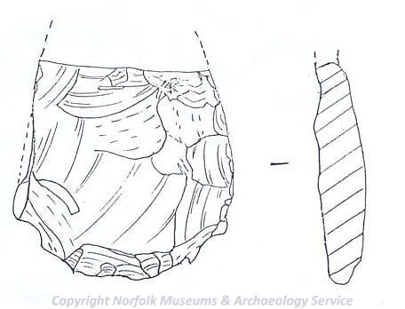
A flint discoidal knife dating to the Late Neolithic or the Early Bronze Age found in Easton. (© NCC.)
The earliest finds are prehistoric worked flints. These mostly date to the Neolithic to Early Bronze Age and include a Neolithic axe (NHER
7809) and a Neolithic or Early Bronze Age discoidal knife or dagger (NHER
36098). The large number of these finds is mostly due to the fieldwalking survey carried out over most of the parish. This has also enabled identification of a possible Neolithic to Early Bronze Age flint working site (NHER
9237). As well as flint production there is evidence to suggest that at least part of the parish was laid out in a prehistoric field system (NHER
16309). Two possible Bronze Age ring ditches (NHER
36741 and NHER
30557) have been identified from aerial photographs and Bronze Age pits (NHER
25703) have also been excavated. Extensive archaeological recording at the Longdell Hills gravel extraction site (NHER
36414) has enabled us to understand more about the use of the landscape during the prehistoric period. Here the earliest evidence for activity is Early Neolithic deposition in a tree throw hollow. This may have been a convenient place to throw away rubbish or may have had some ritual purpose. Similar deposition patterns have been seen elsewhere in Britain. Bronze Age and Early Iron Age timber structures have been recorded (these could not be identified by fieldwalking alone) and there is possible evidence for Iron Age ritual deposition of pottery. Probable prehistoric unurned cremation burials were excavated. This type of evaluation enables us to understand how the landscape has been used in the past before quarrying destroys it.
The site also gives us evidence for Roman use of the landscape that seems to continue to be mainly agricultural. The discovery of a 4th century AD Roman coin hoard (NHER 7814) in the 19th century is not well recorded but may have contained about 4000 copper alloy coins. There is little other evidence for Roman activity. Fieldwalking and metal detecting ahead of the building of the bypass recovered fragments of Roman pottery (NHER 14284, 17037 and 25702), including the handle of a Spanish amphora (NHER 15898), and Roman coins (NHER 16308 and 29043) but there is no evidence for settlement or occupation.
The entry in the Domesday Book for Easton suggests that the village may have a Saxon origin but there is very little evidence for Saxon activity in the parish. The only record is for an Early Saxon cruciform brooch (NHER 34886) found by a metal detectorist. The brooch probably comes from a grave. The rest of Saxon Easton may all be hidden under the modern village.

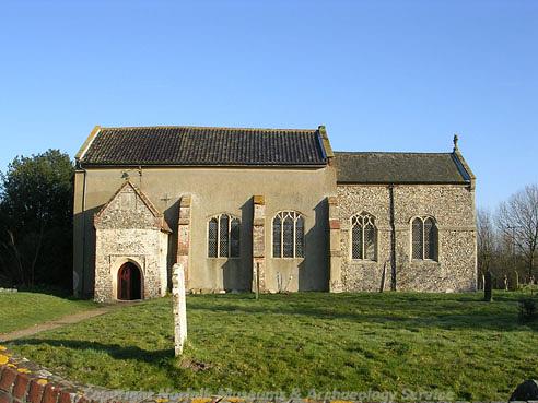
St Peter's Church, Easton. (© NCC.)
There is more surviving evidence from the medieval period. The base of a medieval cross (NHER
7819) stands on the Green and St Peter’s church (NHER
7827) is a Late Norman building with considerable 13th and 15th century alterations. It was completely restored in the 19th century giving it its modern appearance. The medieval landscape was probably still mainly agricultural – several medieval banks (NHER
12608) have been recorded and these may have been used as field boundaries. Scatters of medieval pottery (NHER
25702 and
29045) may have been spread by manuring these fields whilst medieval coins (NHER
17938 and
29043) found by metal detectorists are more likely to be casual losses. Many medieval charcoal burning pits (NHER
36414) have been recorded at the Longdell Hills site. These demonstrate that part of the landscape was managed woodland. There are no surviving medieval buildings in the parish although the Georgian Easton Lodge (NHER
17138) is said to stand on the site of an earlier medieval lodge.
Several post medieval buildings are still standing however. Bellevue (NHER 19258) is an excellent example of a 16th century hall house and West Lodge (NHER 12600) is a Jacobean building. It was once the lodge for Costessey Park. Parts of the The Dog (NHER 12837) and Hill Farm (NHER 19257) are 17th century. The principal’s house (NHER 19820) at Easton College is a good example of an 18th century building with 20th century refurbishing.
Megan Dennis (NLA), 10th November 2005.
Further Reading
Brown, P. (ed.), 1984. Domesday Book, 33 Norfolk, Part I and Part II (Chichester, Phillimore)
Ditton, J., Unknown. ‘Easton Remembered’. Available:
http://showcase.commedia.org.uk/article/view/264/1/1/. Accessed: 31 January 2006.
Mills, A.D., 1998. Dictionary of English Place Names (Oxford, Oxford University Press)
Rye, J., 2000. A Popular Guide to Norfolk Place-names (Dereham, The Larks Press)