This Parish Summary is an overview of the large amount of information held for the parish, and only selected examples of sites and finds in each period are given. It has been beyond the scope of the project to carry out detailed research into the historical background, documents, maps or other sources, but we hope that the Parish Summaries will encourage users to refer to the detailed records, and to consult the bibliographical sources referred to below. Feedback and any corrections are welcomed by email to heritage@norfolk.gov.uk
Caistor St Edmund is a parish just south of Norwich, situated between Keswick and Bixley parishes. The parish includes two villages – Caistor St Edmund itself and the old village of Markshall that has now dwindled to only Markshall Farm and a few farm cottages. Caistor is named after the Roman town of Venta Icenorum, and is derived from the Latin castra meaning camp or town. The St Edmund suffix records how the Abbey of Bury St Edmunds owned the parish, as is recorded in the Domesday Book. The name Markshall probably derives from Old English meaning Maerec’s corner or nook, and in the Domesday Book it is recorded as being a thriving village. The construction of the southern Norwich bypass and the Harford Park and Ride scheme resulted in more archaeological work being carried out in the parish. Interest in the Roman town of Venta Icenorum was sparked in the 1930s after aerial photography of the town revealed extensive patterns of streets and settlement. This lead to excavations and field walking and metal detecting surveys that have increased our knowledge of the landscape of the parish in the Roman period. But the archaeology of the area is more extensive than just the Roman town, and the earliest evidence dates from the Palaeolithic period. The area south of Norwich has been a focus of activity since prehistoric times.
The earliest find is a Palaeolithic flint handaxe (NHER 9776). Other flint tools have also been found scattered across the parish including Mesolithic flint microliths (NHER 9580) and a Neolithic flint handaxe (NHER 24796). The proximity of the Rivers Yare, Wensum and Tas make this area important. They provided vital resources such as fish and birds, and the river valleys provided grazing land. Prehistoric monuments in the parish demonstrate that people were settled in the area from the Neolithic period when they constructed a series of possible henge monuments (NHER 9582 and 9789) perhaps related to nearby Arminghall Henge (NHER 6100). This group of henges suggests that this area was an important ritual and ceremonial centre during the Neolithic period. There is also evidence for possible Neolithic flint mining from the river valley (NHER 9584) and Neolithic pits (NHER 9584). Excavations at the Harford Park and Ride site has even uncovered evidence of Early Neolithic structures, postholes, gullies and pits (NHER 39268) and a Late Neolithic palisaded enclosure. Beaker period pottery (NHER 13350) has been recovered from another site.
In the Bronze Age round barrows (NHER 9743 and 9789) were constructed around the confluence of the River Tas and Yare to commemorate the dead. Most of the barrow mounds were flattened by ploughing long ago but the ring ditches around them can still be seen on aerial photographs. In 1989 to 1991 eight Late Neolithic or Early Bronze Age ring ditches (NHER 9794) were excavated in advance of the construction of the A47 Norwich Southern Bypass at Harford Farm. Buried bodies and cremations dated to 3000 to 1500 BC were recovered from the parish. Bronze Age pits (NHER 11757) and fragments of a Bronze Age rapier (NHER 9790) and sickle (NHER 22076) have also been recovered. A Late Bronze Age burial (NHER 39268) accompanied by two copper alloy axeheads, an iron awl and five pieces of gold leaf was excavated at the Park and Ride site, demonstrating the wealth of some of the inhabitants of the area. Despite the use of copper alloy during the Bronze Age and the adoption of iron in the Iron Age, flint was still an important material. The discovery of fifty eight Late Bronze Age or Early Iron Age worked flint fragments (NHER 40406) in the southwest of the parish demonstrates that flint was still worked and used in the area during this period.
Numerous finds of pottery, metalwork and coins show that Iron Age communities lived in the area. The scatter of Iron Age pottery and coins found around the Roman town (NHER 9786) and temple complex (NHER 9787) suggests that there was Iron Age occupation here before the Roman settlement, although no excavation has been able to test this theory. Evidence for Middle Iron Age occupation and Late Iron Age enclosures (NHER 9794) at Harford Farm and Iron Age ditches (NHER 39268) at Harford Park and Ride has been revealed by excavation. There were no clues to suggest the presence of these Iron Age sites before the excavations and these unexpected discoveries suggest that there may be more evidence for Iron Age use of the landscape in the parish, but it cannot be found without further research.

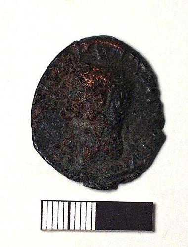
The obverse of a Roman as coin from the site of a Roman temple in Caistor St Edmund. NWHCM 1929.152.11:A
(© NCC)
There are extensive Roman remains from the area. The Roman tribal capital town Venta Icenorum (NHER
9786) was probably founded around AD 60 and was occupied throughout the Roman period until the 4th century AD. The town went through several phases of occupation. Four defensive ditches (NHER
32584) may belong to an early military occupation, perhaps a fort, and were filled in by the 2nd century AD. Roman settlement (NHER
9759,
9791,
9815,
12575 and
24901) developed around this early site and it probably wasn’t until the mid to late 3rd century AD that the flint defensive walls, ditch and rampart were built to enclose part of the regular street plan. This plan was probably laid out in the 1st century AD over a wide area and is very clear on aerial photographs. Within the 3rd century walls a forum, two temples and several domestic buildings were excavated in the 1930s. The importance of the town as a tribal capital and administrative centre is underlined by the identification of a possible Roman amphitheatre and temple (NHER
9836) from aerial photographs and geophysical surveys to the south of the walled town. A walled religious temple complex (NHER
9787) has also been identified to the northeast and systematic metal detecting here suggests that this was in use from the 1st to the 4th centuries AD, and that there was also Roman occupation around the temple. Excavations demonstrated that the latest buildings were constructed in the 4th century AD.
There is also evidence for Roman industrial activity within the parish. Roman kilns (NHER 9786 and 9788) and a copper alloy furnace (NHER 9816) have been excavated. Roman graves (NHER 9791 and NHER 9827), including one skeleton buried with four copper alloy bracelets, have also been recovered. This concentration of Roman activity is linked together by a network of Roman roads (NHER 9816, 9863, 12581 and 18194) that converge at Venta. Fieldwalking around the Roman town has also revealed the importance of the River Tas as a communication route. A concentration of Late Roman coins (NHER 29994) from here are probably related to late 3rd and 4th century trade. There is also evidence for a Roman ford or bridge (NHER 9822) across the river. More rural Roman remains at Harford Park and Ride site included field boundaries and a Roman aisled barn (NHER 39268).

A Roman barbarous radiate coin from Caistor St Edmund. NWHCM 1944.120.60a:A
(© NCC)
After the Roman period the walled part of the town appears to have fallen into disuse. There is no evidence for Saxon settlement within the walls, although the number of Middle Saxon finds (NHER
9759) from around the town, especially to the west, suggests there may have been some continuity of settlement in the area. Aerial photographs show at least one area of possible Early Saxon sunken feature timber buildings or grubenhauser (NHER
31550). The area was clearly still inhabited as Caistor St Edmund and Markshall villages are both recorded in the Domesday Book and three Early Saxon cemeteries (NHER
9788,
9791 and
9794) in the parish have been completely excavated or destroyed. The cemetery at Markshall was excavated in the 19th century and was a cremation cemetery. The second cemetery overlooks Venta, and was excavated between 1932 and 1935 when 500 cremations and 57 inhumations were recorded.

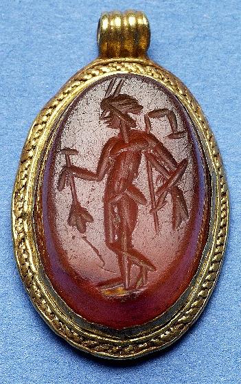
A Roman intaglio remounted in the Early Saxon period and made into a pendant. The pendant was found on the site of Harford Park and Ride. NWHCM 1994.5.235:A
(© NCC)
The third cemetery at Harford Farm was excavated during development of the Norwich Southern Bypass. It was used between the 7th and 8th centuries AD when bodies were either buried in coffins or placed directly into the grave. Some of the graves contained rich jewellery and other wealthy items. These Early Saxon cemeteries are not Christian and all predate St Edmund’s church (NHER
1860) which retains some Saxon features despite being mostly 13th and 15th century in construction. Its location within the walled area of the Roman town suggests this area may have been kept apart from normal life that continued outside the walls.
In the medieval period a possibly moated medieval manor was built on the present site of Caistor Old Hall (NHER 9853) but was replaced by the present building that was built in 1612. This manor may have owned the medieval free chapel (NHER 39466) in the parish that is recorded in 1535 in a list of church buildings and property, but whose location has now been lost. It was during the medieval period that Markshall village and church (NHER 9795) was gradually deserted, although no clear date or reason for this desertion is known. The last remains of Markshall church were destroyed when the railway line was built through them in 1847. It seems there was more dense occupation of the land in this period than today. There is also evidence of medieval occupation further north – a medieval house (NHER 9584) was excavated just north of the bypass in 1949.

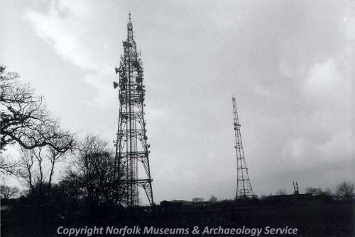
Two World War Two radar masts in Caistor St Edmund. (© NCC)
Several post medieval drainage ditches (NHER
41821 and 9584) and field boundaries (NHER
9743) have been identified and several houses from the parish date from this period. Caistor Hall (NHER
9817) was built in the 18th century, as was an old barn (NHER
9861) into which some windows from Markshall church are supposed to have been inserted. The windows are no longer present. Neither is the building that predates 19th century Old French Church Farm (NHER
19355) which was given to the French Walloon Church in Norwich in the 18th century or Markshall Bridge (NHER
41839) over the River Tas which was rebuilt in 1880.
More modern archaeological buildings from World War Two do, however, remain. These include a pillbox (NHER 9889), an anti-aircraft battery (NHER 12627) and a very early radar beacon site (NHER 14227) that may be one of the first constructed in Britain. It is clear that there is a wide range of archaeological remains within the parish, and some very interesting sites that may have been overshadowed in the past by the wealth of well known prehistoric and Roman archaeology in the area.
Megan Dennis (NLA), 26th October 2005.
Further Reading
Ashwin, T.M. and Bates, S.J., 2000. 'Excavations on the Norwich Southern Bypass 1989-91. Part I: Excavations at Bixley, Caistor St Edmund and Trowse', East Anglian Archaeology 91.
Brown, P. (ed.), 1984. Domesday Book, 33 Norfolk, Part I and Part II (Chichester, Phillimore)
Davies, J., 2001. Venta Icenorum. Caistor, St Edmund Roman Town (Norfolk Archaeological Trust)
Mills, A.D., 1998. Dictionary of English Place Names (Oxford, Oxford University Press)
Neville, J., 2003. ‘Norfolk Mills – Caistor St Edmund watermill’. Available:
http://www.norfolkmills.co.uk/Watermills/caistor-st-edmund.html. Accessed 15 February 2006.
Norfolk Archaeological Trust, 2004. ‘Norfolk Archaeological Trust’. Available:
http://www.norfarchtrust.org.uk/caistor/index.htm#contents. Accessed 15 February 2006.
Peterson, J., 2005. ‘Tour of Caistor Roman Town’. Available:
http://www.sys.uea.ac.uk/Research/researchareas/JWMP/CaistorRomanTown/crtp1.html. Accessed 15 February 2006.
Rye, J., 2000. A Popular Guide to Norfolk Place-names (Dereham,The Larks Press)
Unknown, unknown. ‘Venta Icenorum’. Available:
http://www.roman-britain.org/places/venta_icenorum.htm. Accessed 15 February 2006.