This Parish Summary is an overview of the large amount of information held for the parish, and only selected examples of sites and finds in each period are given. It has been beyond the scope of the project to carry out detailed research into the historical background, documents, maps or other sources, but we hope that the Parish Summaries will encourage users to refer to the detailed records, and to consult the bibliographical sources referred to below. Feedback and any corrections are welcomed by email to heritage@norfolk.gov.uk
Earsham is a large parish in the southeast of Norfolk located in the valley of the River Waveney that forms the boundary between Norfolk and Suffolk. The valley is part of a low rolling landscape that is now used mostly for pasture, with some woodland. The village is mentioned at length in the Domesday Book where two mills are recorded. The name stems from Old English for ‘the Earl’s homestead’ or ‘the village belonging to Eanhere’. There was settlement here from the Saxon period onwards but the archaeology from the parish also records much earlier activity.
The oldest finds are a group of Mesolithic worked flints (NHER 22243) including a microlith, a blade and a burin. Several Neolithic worked flints have also been recovered from the parish including two Neolithic flint axeheads (NHER 11107 and 16276), a Neolithic knife (NHER 23488) and a Neolithic leaf-shaped arrowhead (NHER 10629). The first recorded prehistoric monuments date to the Bronze Age. Work on aerial photographs of the parish by the Norfolk National Mapping Programme (Broads Zone) in 2006-7 has identified a dispersed Bronze Age barrow cemetery (NHER 43612), with at least four ring ditches, a more complex undated causewayed enclosure (NHER 17334) and a rare triple-ditched linear boundary (NHER 11676) of probable Late Bronze Age to Iron Age date. The only other prehistoric site is a possible prehistoric burnt mound (NHER 37472). If this is correctly identified its location is unusual. It was found on the top of the Waveney Valley rather than the more usual situation in the valley bottom, close to a water supply.
There is little evidence for Roman activity in the parish. Earthworks from around All Saints’ Church that were destroyed in the 19th and early 20th centuries were called a Roman camp but this interpretation isn’t clear. Roman pottery and coins (NHER 11110) were found there but Saxon objects were also recovered. Making sense of the early records isn’t easy. A Roman pit (NHER 10198) containing pottery and other objects is easier to identify and Roman coins (NHER 11111 and 35247) have been found at two other spots in the parish. Roman pottery (NHER 22243) dredged from the River Waveney suggests this may have been used, as it was in later periods, to transport trading goods inland.
Despite the evidence in the Domesday Book that suggests that Earsham was an important local centre in the Late Saxon period there is very little Saxon archaeology recorded from the parish. This is not unusual in Norfolk. The demolition of earthworks around the church in the 19th and 20th centuries led to the recovery of a number of Early Saxon pots containing cremations. This was the site of an Early Saxon cemetery (NHER 11110) that was later replaced by All Saints’ church (NHER 11118). Although the earliest parts of the present building date to the Saxon or Norman period this was probably the site of an earlier, possibly wooden Saxon church.

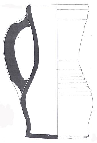
13th century green glazed pitcher found by divers in the River Waveney at Earsham. (© NCC)
During the medieval period the landscape was dominated by the medieval manor and park of the Bigod family, and later, the Dukes of Norfolk. The possible location of their medieval manor house (NHER 44457) has been identified from aerial photographs and a second possible manor house (NHER 16278) at No. 33 Marsh Lane still stands. Earsham Park (NHER 30500) wasn’t laid out until the 18th century, but the earlier medieval deer park (NHER 16277), medieval fish ponds (NHER 11114) and medieval ridge and furrow (NHER 29787 and 29788) can be seen within its later boundaries. A medieval boundary ditch (NHER 41644) has also been excavated in the parish. Medieval finds include a 13th century pottery pitcher (NHER 11112) that was found by divers in the River Waveney and 13th to 14th century pottery fragments (NHER 21803) found underneath the floor at Whitehouse Farm.

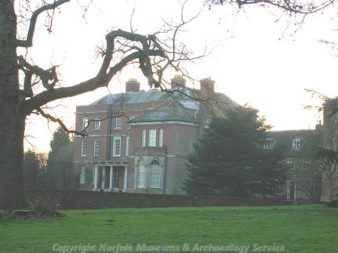
Earsham Hall, an 18th century red brick construction designed by John Buxton. (© NCC)
In the 17th century Earsham Hall (NHER
11115) was constructed, replacing the possible earlier building. John Buxton designed the house. The Music Room (NHER
16275), in an isolated position in the park, was added in 1785 and was designed by John Soanes. There are several other post medieval buildings that remain in the village including Upper Green Farm (NHER
34623) that has a very unusual layout. During this period it was usual to protect your house from harm using charms and special inscriptions. One example of these types of apotropaic markings can be seen on the fireplace at the Queen’s Head Inn (NHER
35943) where the letters AM for Ave Maria are scratched into the wood. Another type of charm, a witch’s bottle (NHER
16279), was found in the fireplace of a 17th century house. The post medieval bath house (NHER
24755) at Bath Hills may be the bath house that was used when the neighbouring Suffolk town of Bungay was a popular spa resort. Excavations in the parish have also identified a possible post medieval quarry pit and post holes (NHER
41644).

X-ray of a witch bottle found in Earsham. (© NCC)
In the modern period Earsham Airfield (NHER
13612) was used during World War One as a 3rd class landing ground. A Zeppelin which was trying to hit the airfield mistakenly bombed the nearby farm. In World War Two Beech Wood and some others in neighbouring Hedenham were closed and used as a massive bomb store (NHER
41374) by the United States Army Air Force. Bombs were brought there by railway and then shipped by lorry to airfields all over East Anglia. The site of the headquarters of the bomb store (NHER
41375) is located close to Hall Farm.
Megan Dennis (NLA), 1st November 2005.
David Gurney (NLA), 28 March 2008.
Further Reading
Brown, P. (ed.), 1984. Domesday Book, 33 Norfolk, Part I and Part II (Chichester: Philimore)
Knott, S., 2005. ‘All Saints Earsham’. Available:
http://www.norfolkchurches.co.uk/earsham/earsham.htm. Accessed: 1 February 2006.
Mills, A.D., 1998. Dictionary of English Place Names (Oxford, Oxford University Press)
Neville, J. 2004. ‘Norfolk Mills – Earsham watermill’. Available:
http://www.norfolkmills.co.uk/Watermills/earsham.html. Accessed: 1 February 2006.
Stratford, S., Unknown. ‘Earsham War Memorial’. Available:
http://www.stephen-stratford.co.uk/earsham.htm. Accessed: 1 February 2006.
Rye, J., 2000. A Popular Guide to Norfolk Place-names (Dereham:The Larks Press)